This item has been sold, but you can get on the Waitlist to be notified if another example becomes available, or purchase a digital scan.
1760 Vezou and Lattré Scientific Map of the World
MappeMonde-vezou-1760$1,000.00

Title
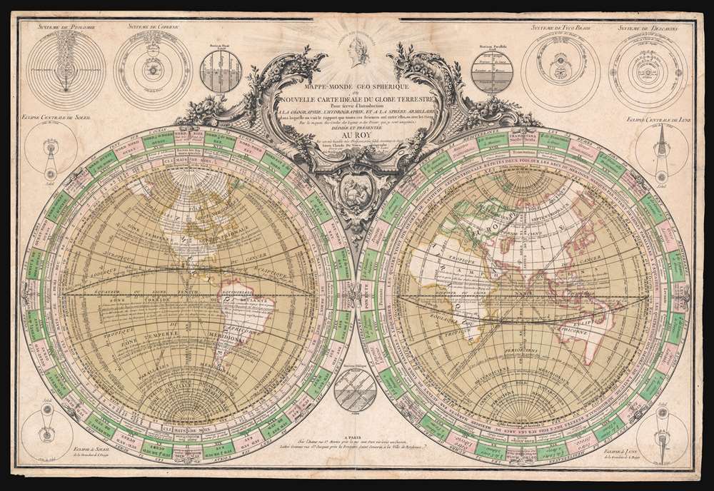
Mappe-Monde Geo Spherique ou Nouvelle Carte Ideale Du Globe Terrestre Pour servir d'Introduction a la Geographie, L'Hydrographie, et a la Sphere Armillaire . . . 1760.
1760 (undated) 21.25 x 30.5 in (53.975 x 77.47 cm) 1 : 100000000
1760 (undated) 21.25 x 30.5 in (53.975 x 77.47 cm) 1 : 100000000
Description
This is a rare separate issue c. 1760 Louis Claude de Vézoue (Vezou) and Jean Lattré map of the world in hemispheres. This striking map combines the principles of geography with 18th century popular astronomical sciences and was intended as a pedagogical introduction to both. An informationally dense piece, it is replete with data and annotations explaining winds, currents, weather patterns, astronomy, and geography. Diagrams illustrating the four theories on the universe, solar and lunar eclipses, and the horizons surround the central map. Surmounting the map is an effigy of French King Louis XV, to whom the map is dedicated.
The Geography
The map is geographically curious. It postdates the voyages of Vitus Bering (1681 - 1741) but predates the major navigations of James Cook (1728 - 1779) and so offers an accurate Siberia, but speculative illustration of the American west, including a bold River of the West. Although the Great Lakes are engraved with a semblance of accuracy, the colorist, clearly unfamiliar with North American geography, created a vast inland sea south of Hudson Bay occupying most of modern-day Ontario and Quebec. On the opposite side of the world, the mainland of Australia is connected to New Guinea - a common error of the period.Publication History and Census
This map was engraved and published by Jean Lattré in partnership with Louis Claude de Vézoue. The map first appeared in 1753 as a separate issue wall map, measuring some 45 inches wide, containing an extensive textual surround nearly doubling the size of the map sheet. The plate was revised c. 1760 for the present smaller format edition and the surrounding text removed and partially replaced with astronomical diagrams. As a separate issue, the map is rare, but can sometimes be found tipped into composite atlases and large format Lattré atlases.CartographerS
Louis Claude de Vézoue (17?? - 1782), sometimes spelled Vezou, was a French mathematician, mapmaker, genealogist, engineer, historiographer, and astronomer active in Paris during the middle and late 18th century. In 1853 he issued an important educational wall map of the world in partnership with Jean Lattré, this was reissued c. 1760. In 1773, as historiographer to the king, he completed a detailed genealogical chart of the Kings of France. More by this mapmaker...
Jean Lattré (170x - 178x) was a Paris based bookseller, engraver, globe maker, calligrapher, and map publisher active in the mid to late 18th century. Lattré published a large corpus of maps, globes, and atlases in conjunction with a number of other important French cartographic figures, including Janvier, Zannoni, Bonne and Delamarche. He is also known to have worked with other European cartographers such as William Faden of London and the Italian cartographer Santini. Map piracy and copyright violations were common in 18th century France. Paris court records indicate that Lattré brought charges against several other period map publishers, including fellow Frenchman Desnos and the Italian map engraver Zannoni, both of whom he accused of copying his work. Lattré likes trained his wife Madame Lattré (né Vérard), as an engraver, as a late 18th century trade card promotes the world of 'Lattré et son Epouse.' Lattré's offices and bookshop were located at 20 rue St. Jaques, Paris, France. Later in life he relocated to Bordeaux. Learn More...
Condition
Good. Edges fragile, but intact. Closed minor edge tears professionally repaired on verso. Verso repair to a centerfold separation. Minor damp stains. Overall toning. Old color.
References
Phillips (Atlases) 641. Rumsey 11335.006. OCLC 494748552.