This item has been sold, but you can get on the Waitlist to be notified if another example becomes available, or purchase a digital scan.
1848 Hobbs Blueback Nautical Map of Newfoundland, Nova Scotia, Canada
MaritimeProvinces-hobbs-1848$750.00

Title
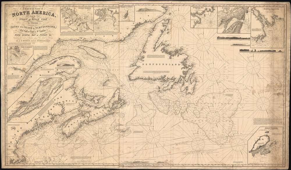
A Chart of the Coast of North America, from the Strait of Belle Isle to Boston including the Banks and Island of Newfoundland, The Gulf and River of St. Lawrence, Nova Scotia, Bay of Fundy, and c.
1848 (dated) 40 x 60.5 in (101.6 x 153.67 cm) 1 : 23000
1848 (dated) 40 x 60.5 in (101.6 x 153.67 cm) 1 : 23000
Description
A scarce 1848 John Stratton Hobbs British blueback nautical chart or maritime map of the Canadian Maritime Provinces and the Gulf of St. Lawrence. The map covers from Labrador to Boston, including Newfoundland, Nova Scotia, Anticosti Island, and New Brunswick, as far as Cape Cod, including the entire New England coastline from Connecticut to Maine. Inset maps detail Halifax Harbor, Boston Harbor, St. John, the Island of St. Paul, Port St. Andrew, Liverpool Bay, St. Johns, and the Island of St. Pierre. Exhibit copious soundings and annotations of practical use to the mariner.
Blueback Charts
Blueback nautical charts began appearing in London in the late 18th century. Bluebacks, as they came to be called, were privately published large format nautical charts known for their distinctive blue paper backing. The backing, a commonly available blue manila paper traditionally used by publishers to warp unbound pamphlets, was adopted as a practical way to reinforce the low-quality paper used by private chart publishers in an effort to cut costs. The earliest known blueback charts include a 1760 chart issued by Mount and Page, and a 1787 chart issued by Robert Sayer. The tradition took off in the early 19th century, when British publishers like John Hamilton Moore, Robert Blachford, James Imray, William Heather, John William Norie, Charles Wilson, David Steel, R. H. Laurie, and John Hobbs, among others, rose to dominate the chart trade. Bluebacks became so popular that the convention was embraced by chartmakers outside of England, including Americans Edmund March Blunt and George Eldridge, as well as Scandinavian, French, German, Russian, and Spanish chartmakers. Blueback charts remained popular until the late 19th century, when government subsidized organizations like the British Admiralty Hydrographic Office and the United States Coast Survey, began issuing their own superior charts on high quality paper that did not require reinforcement.Publication History and Census
This map was compiled by John Stratton Hobbs and published by John Norie and Charles Wilson in London. There appears to be but one edition, 1848. The map may have been derived from an earlier map produced by Steel in 1834 - 1836, but we have been unable to verify this. The map is scarce with the OCLC citing only a single example at the British Library. No other examples known.CartographerS
John Stratton Hobbs (January 1, 1813 - December 19, 1874) was a British engraver, hydrographer, chart maker, and blueback publisher active in England in the mid-19th century. Hobbs was born in London, the son of William Henry Hobbs, a ship broker of Globe Street, St. George in the East. Much of his work is associated with the firms of John William Norie (1774 - 1843) and Charles Wilson (1807 - 1882). Hobbs compiled charts and engraved for Norie until his death in 1843, when he became head of the hydrographic department of the successor firm, Noire and Wilson. He was elected to the Royal Geographical Society 9 November 1846. More by this mapmaker...
John William Norie (June 3, 1772 - December 24, 1843) was a British teacher of navigation, hydrographer, chart maker, and publisher of maritime manuals active in London, England in the late 18th and early 19th centuries. Norie was born in Wapping, London, an area long associated with the maritime sciences. Norie's career as a chart maker commenced under the tutelage of William Heather, a prominent purveyor and publisher of nautical charts, pilot books, and navigational tools who took over the firm of Mount and Page in 1765. Heather and Norie were likely acquainted through John Hamilton Moore, another important chart maker with whom both seem to have been associated early in their careers. Heather hired Norie to teach basic navigation at his shop at 157 Leadenhall Street. Under Heather Norie also distinguished himself as a draftsman, completing many of the early charts associated with the Heather firm. When Heather died in 1812 John Norie partnered with George Wilson, a moneyed 'man about town' with little experience in the maritime trades, to acquire the map and chart business at 9500 British Pounds. It proved a good deal for Norie, who retained all copyright privileges and drew 1/4 quarter share of business profits, as well an impressive quarterly salary and, for doing all of the work, 1/3rd of Wilson's share. The firm, referred to as the 'Naval Warehouse' quickly acquired a reputation for quality navigational materials and became a favorite of merchant seamen. It was even referenced in Charles Dickens' classic novel Dombey and Son. In 1819, Norie and Wilson acquired the failing chart business of David Steel, which significantly increased the size, though not quality, of their chart catalogue. With the rise of the British Admiralty and its own maritime chart productions, the business of "Chart Purveyor" in London dramatically changed. Admiralty charts and pilot books, designed for military use, were offered through established intermediaries, like Norie, at bargain prices. Most chart makers of the period found it profitable to use the highly technical Admiralty charts to update their own more decorative vernacular charts. For a brief time this practice proved exceptionally profitable but eventually began to draw criticism. Nonetheless, Norie retired to Edinburgh in 1840 and died a wealthy man in 1843. In 1840 the business passed to a nephew of George Wilson, Charles Wilson, who renamed the firm "Norie & Wilson". William Heather Norie, J. W. Norie's own son, produced few charts, instead pursuing a career in the legal field. Norie & Wilson merged with James Imray's prosperous chart business in 1899, becoming Imray, Laurie, Norie & Wilson, a profitable concern that remains active in the maritime charting industry. Learn More...
Charles Wilson (1807 - May 16, 1882) was a British-Indian publisher of nautical charts and maps based in London, England. Born in Lucknow, India, Wilson was the son Lieutenant-Colonel William Wilson and his wife Hoosainee Begum, an Indian princess, who was the daughter of the Nizam of Ashrafabad. Wilson was educated in England and worked in the wine trade before joining the Norie firm in 1838. Norie had already partnered with another Wilson, George, who was a nephew to Charles. When Norie retired in 1840, Charles Wilson took over the firm publishing as 'Charles Wilson (Late J.W. Noire and Wilson)'. He married Jane Arabella Bingle on July 1, 1846. Wilson died in 1882 passing the firm on to his sons, George and William Wilson. The brothers merged the firm with that of J. Imray and Sons in 1899 and, as Imray, Laurie, Norie and Wilson Ltd., they continue to publish to the present day. Learn More...
Condition
Good. Working nautical chart. Even toning. Verso reinforcement. Some discoloration. Original blue paper backing and edging. Discoloration right side.
References
OCLC 557331209.