This item has been sold, but you can get on the Waitlist to be notified if another example becomes available, or purchase a digital scan.
1935 Parker Pictorial Map of Martha's Vineyard, Massachusetts with Envelope
MarthasVineyard2-parker-1935$475.00

Title
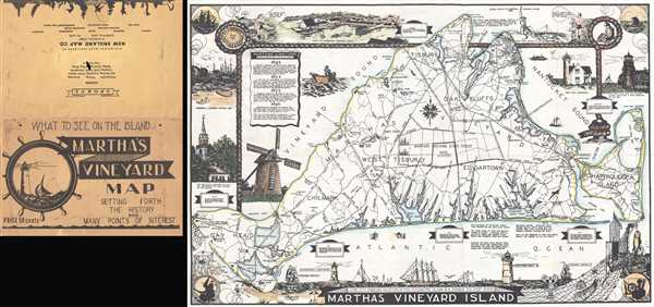
Martha's Vineyard Island.
1935 (undated) 14.25 x 21.75 in (36.195 x 55.245 cm) 1 : 46000
1935 (undated) 14.25 x 21.75 in (36.195 x 55.245 cm) 1 : 46000
Description
This is a c. 1935 L. H. Parker pictorial map of Martha's Vineyard. The map depicts the entirety of Martha's Vineyard from Gay Head and Gay Head Lighthouse to Chappaquiddick Island and from the West Chop Lighthouse to the Atlantic Ocean. Each of Martha's Vineyard's six townships are illustrated and labeled, as well as shaded different colors to allow for easy differentiation. Numerous locations throughout the island are also labeled, including lighthouses, ponds, beaches, bays, and points. Roads crisscross the island and Martha's Vineyard State Forest dominates its center. Charming vignettes frame the central map, illustrating towns, buildings, and local trades, such as fishing and a lobsterman hauling in his catch. A wonderful depiction of the Gay Head Light is situated along the right border, while a fisherman's net and a lovely beach scene provide the frame along the bottom border.
This map was created by L. H. Parker and published c. 1935.
This map was created by L. H. Parker and published c. 1935.
Condition
Very good. Even overall toning. Blank on verso. Accompanied by original binder.