
1962 Marin Visitors Bureau Pictorial Tourist Map of Marin County, California

This item has been sold.
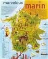
Marvelous Marin.
Muir Woods! and more...
Choose a Collection:
This Item
Enquire
Muir Woods! and more...
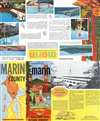
This is a c. 1962 Marin Visitors Bureau pictorial map of Marin County, California. Well-known sites, including the Golden Gate Bridge (labeled here at the 'Gateway to Redwood Empire Vacationland'), Muir Woods National Monument, and Drake's Bay (possibly location of Sir Francis Drake's landing), are illustrated. Other depicted sites include the Richmond-San Rafael Bridge, Mt. Tamalpais, Samuel P. Taylor State Park, and the Point Reyes Lighthouse. A table of distances from the Golden Gate Bridge occupies the lower left. Printed photographs appear on the verso, including a photograph of the newly completed Marin County Civic Center designed by Frank Lloyd Wright.Publication History and Census
This map was created for and published by the Marin Visitors Bureau c. 1962. An empty OCLC reference exists for this piece, suggesting that a former cooperative member created the entry before withdrawing from OCLC.Condition
Very good. Light wear along original fold lines. Text and printed images on verso.
References
OCLC 191804145.