1866 Mitchell Map of New Jersey, Maryland, and Delaware
MarylandNewJersey2-mitchell-1866$100.00

Title
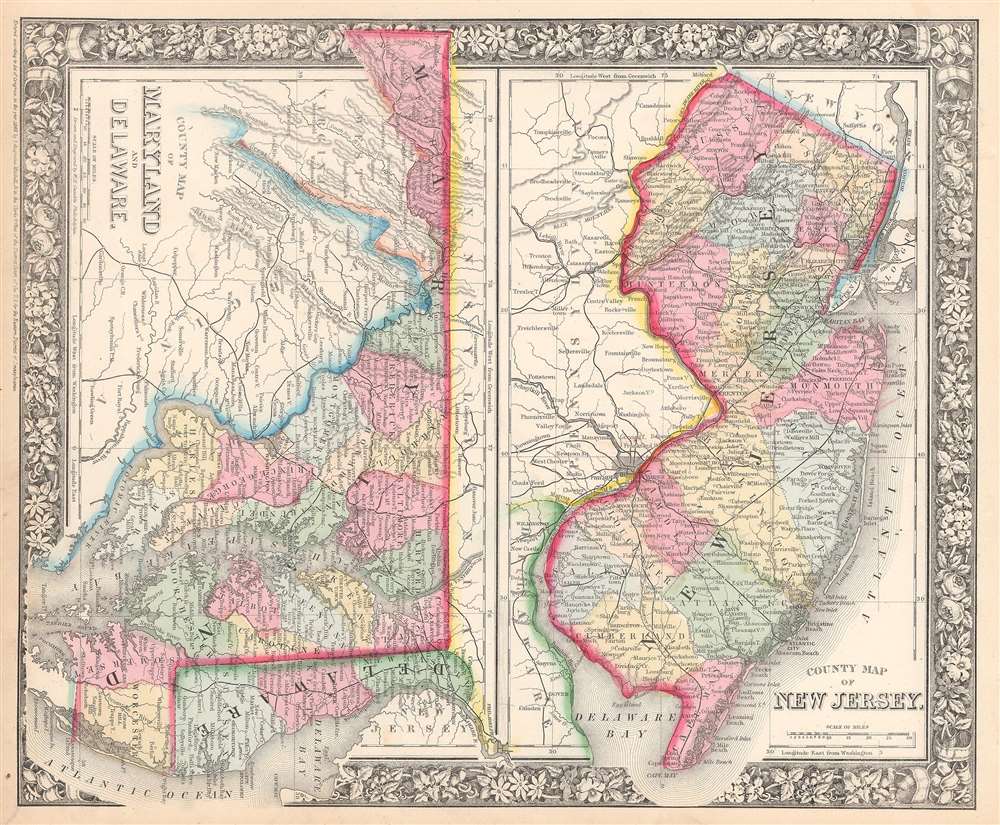
County Map of New Jersey. County Map of Maryland and Delaware.
1865 (dated) 12 x 14.5 in (30.48 x 36.83 cm)
1865 (dated) 12 x 14.5 in (30.48 x 36.83 cm)
Description
This is an 1866 S. A. Mitchell Jr. map of New Jersey, Maryland, and Delaware. The map depicts the entirety of New Jersey from Pennsylvania and Delaware to New York and the Atlantic Ocean and from Pennsylvania and New York to Delaware Bay. Maryland and Delaware and shown together, with the region depicted from West Virginia to New Jersey and from Pennsylvania to Virginia. Counties are labeled and shaded different colors in all three states to allow for easy differentiation. Myriad cities, towns, and villages are identified, including Washington, D.C. Roads, railroads, rivers, and bays throughout the illustrated regions also are identified. The whole features the floral border typical of Mitchell maps from the 1860-66 period.
Prepared by S. A. Mitchell Jr. for inclusion as plate 24 1/2 in the 1866 issue of Mitchell's New General Atlas. Dated and copyrighted, 'Entered according to Act of Congress in the Year 1865 by S. Augustus Mitchell Jr. in the Clerk's Office of the District Court of the U.S. for the Eastern District of Pennsylvania.'
Prepared by S. A. Mitchell Jr. for inclusion as plate 24 1/2 in the 1866 issue of Mitchell's New General Atlas. Dated and copyrighted, 'Entered according to Act of Congress in the Year 1865 by S. Augustus Mitchell Jr. in the Clerk's Office of the District Court of the U.S. for the Eastern District of Pennsylvania.'
Cartographer
Samuel Augustus Mitchell (March 20, 1792 - December 20, 1868) began his map publishing career in the early 1830s. Mitchell was born in Bristol, Connecticut. He relocated to Philadelphia in 1821. Having worked as a school teacher and a geographical writer, Mitchell was frustrated with the low quality and inaccuracy of school texts of the period. His first maps were an attempt to rectify this problem. In the next 20 years Mitchell would become the most prominent American map publisher of the mid-19th century. Mitchell worked with prominent engravers J. H. Young, H. S. Tanner, and H. N. Burroughs before attaining the full copyright on his maps in 1847. In 1849 Mitchell either partnered with or sold his plates to Thomas, Cowperthwait and Company who continued to publish the Mitchell's Universal Atlas. By about 1856 most of the Mitchell plates and copyrights were acquired by Charles Desilver who continued to publish the maps, many with modified borders and color schemes, until Mitchell's son, Samuel Augustus Mitchell Junior, entered the picture. In 1859, S.A. Mitchell Jr. purchased most of the plates back from Desilver and introduced his own floral motif border. From 1860 on, he published his own editions of the New General Atlas. The younger Mitchell became as prominent as his father, publishing maps and atlases until 1887, when most of the copyrights were again sold and the Mitchell firm closed its doors for the final time. More by this mapmaker...
Source
Mitchell Jr., S. A., Mitchell's New General Atlas, containing Maps of the Various Countries of the World, Plans of Cities, Etc., Embraced in Fifty-five Quarto Maps, forming a series of Eighty-Seven Maps and Plans, together with Valuable Statistical Tables. 1866 Edition.
Mitchell's New General Atlas was published by Samuel Augustus Mitchell, Jr., the son of the prolific cartographer Samuel Augustus Mitchell. Many of the plates are derived from the his father's Mitchell's Universal Atlas, but not directly. The Mitchell's Universal Atlas was initially sold to Thomas, Cowperthwait, and Company in 1849, and again to Charles Deliver in 1856. It was Deliver who introduced the new vibrant color scheme, abandoning the older Mitchell's Universal Atlas green borders and themes for bright reds, blues, and yellows. Samuel Augustus Mitchell, Jr. acquired the Deliver plates in 1859. He added his own floral motif border, but doubled down on the vibrant color scheme, thus introducing to the American public the most vividly colored American atlas of the 19th century. In 1860, he published the first edition of his New General Atlas and, despite a slump in sales during the American Civil War, attained a level of success to rival his father. Mitchell would continue to publish the New General Atlas until 1887, when the firm formally closed.
Condition
Very good. Even overall toning. Blank on verso.
References
Rumsey 0572.021 (1865 edition).