1930 Elizabeth Shurtleff Pictorial Map of Massachusetts
Massachusetts-shurtleff-1930-2$650.00


Title
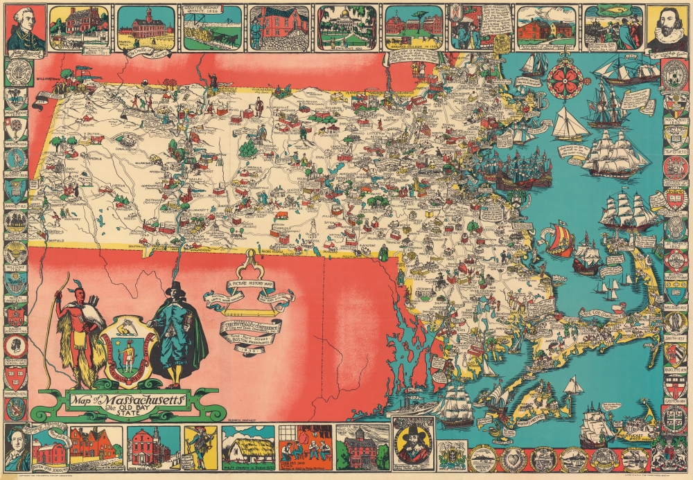
Map of Massachusetts The Old Bay State.
1930 (dated) 26.5 x 38.5 in (67.31 x 97.79 cm)
1930 (dated) 26.5 x 38.5 in (67.31 x 97.79 cm)
Description
An uncommon 1930 pictorial map of Massachusetts issued by Tudor Press and Elizabeth Shurtleff, one of the most prominent female pictorial mapmakers. The map covers all of Massachusetts with vignette cartoon illustrations of various towns. Considerable focus is placed on industry, and many towns are highlighted with factory and/or mill illustrations. Indications of the merchandise produced there are also noted, including knit goods, shoes, jewelry, optical goods, textiles, etc. Other illustrations reference events of the American Revolutionary War. Surrounding the map are decorative armorial crests celebrating the many distinguished institutions of learning located throughout Massachusetts. Among them are Harvard, the Roxbury Latin School, Williams, Phillips Andover, the Bradford Academy, Amherst, Wheaton, the Abbot Academy, Mount Holyoke, Holy Cross, Tufts, MIT, Boston College, St. Marks, and Boston University.
Publication History and Census
This map was drawn by Elizabeth Shurtleff and published by the Tudor Press. There are two states, a 4-color variant - as here - and a 3-color variant without the red tones. We have identified examples of the 4-color variant in 5 institutional collections and are aware of only one example of the 3-color variant.CartographerS
Elizabeth Shurtleff (September 3, 1890 - December 7, 1968), or Elizabeth Cate, was an American painter and artist active in the middle part of the 20th century. She was born in Concord, New Hampshire and attended the Boston Museum School of Fine Arts. Shurtleff is known for a small but significant corpus of pictorial maps issued alone and in collaboration with others between 1926 and 1930. She frequently collaborated with Wellesley graduates and pictorial mapmakers Helen F. McMillin, Elizabeth L. McMillin, and Alva Bennett Scott. These women were at the forefront of a new generation of female mapmakers emerging in the mid-20th century. Together with Helen F. McMillin, Shurtleff headed the Boston based Graphic History Association Publishers of Historical Maps. Elizabeth was married to Carroll L. Cate of Montreal. She died in Montreal in 1968. More by this mapmaker...
Tudor Press (fl. 1910 - 1967) was a Boston based lithograph, offset, and letterpress printer active in Boston throughout the 20th century. They were founded by Ralph Harland Wilbur (1875 - 19??). Wilber learnt the printing trade at the Melrose Journal, a job and book printing business. He struck out on his own, founding Tudor Press in 1910, with offices on Causeway Street, Boston. Ralphs children, Harland, Alvra, and Wesley joined the firm in the 1920s. The press acquired its first four-color offset press in 1940 and was active in printing maps for the war effort. Harland took over the firm in 1941. After World War II, the firm was contracted to issue military currency for U.S. Occupation forces. In 1967, it was relocated to Lawrence, Massachusetts and renamed Graphic Litho. Harland's son Ralph E. Wilbur, took over the firm in 1968. While the name Tudor Press is no longer used, Graphic Litho remains in business. Learn More...
Condition
Very good. Light wear along original fold lines. Verso repair to a fold separation. Closed minor margin tear professionally repaired on verso.
References
OCLC 18001687. Rumsey 8518.000.