This item has been sold, but you can get on the Waitlist to be notified if another example becomes available, or purchase a digital scan.
1831 Mitchell Pocket Map of Massachusetts, Connecticut and Rhode Island
MassachusettsConnecticut-mitchell-1831$275.00

Title
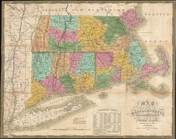
Map Of Massachusetts Connecticut And Rhode Island Constructed From the Latest Authorities.
1831 (dated) 17 x 21.5 in (43.18 x 54.61 cm) 1 : 700000
1831 (dated) 17 x 21.5 in (43.18 x 54.61 cm) 1 : 700000
Description
This is a beautiful pocket map edition of Mitchell’s 1831 map of Massachusetts, Connecticut and Rhode Island. It covers the New England states in their entirety, with color-coding according to counties. Notes several important towns, cities, roads, rivers and topography throughout, with relief shown by hachures.
This map is the pocket map edition of the map from Mitchell’s first atlas, published in the first year of his publishing career from plates purchased from Anthony Finley. The maps were reissued with Mitchell’s imprint with updates and a new border. Engraved by J. H. Young and published by S. Augustus Mitchell in 1831. Pocket map edition from Mitchell’s New American Atlas.
This map is the pocket map edition of the map from Mitchell’s first atlas, published in the first year of his publishing career from plates purchased from Anthony Finley. The maps were reissued with Mitchell’s imprint with updates and a new border. Engraved by J. H. Young and published by S. Augustus Mitchell in 1831. Pocket map edition from Mitchell’s New American Atlas.
Cartographer
Samuel Augustus Mitchell (March 20, 1792 - December 20, 1868) began his map publishing career in the early 1830s. Mitchell was born in Bristol, Connecticut. He relocated to Philadelphia in 1821. Having worked as a school teacher and a geographical writer, Mitchell was frustrated with the low quality and inaccuracy of school texts of the period. His first maps were an attempt to rectify this problem. In the next 20 years Mitchell would become the most prominent American map publisher of the mid-19th century. Mitchell worked with prominent engravers J. H. Young, H. S. Tanner, and H. N. Burroughs before attaining the full copyright on his maps in 1847. In 1849 Mitchell either partnered with or sold his plates to Thomas, Cowperthwait and Company who continued to publish the Mitchell's Universal Atlas. By about 1856 most of the Mitchell plates and copyrights were acquired by Charles Desilver who continued to publish the maps, many with modified borders and color schemes, until Mitchell's son, Samuel Augustus Mitchell Junior, entered the picture. In 1859, S.A. Mitchell Jr. purchased most of the plates back from Desilver and introduced his own floral motif border. From 1860 on, he published his own editions of the New General Atlas. The younger Mitchell became as prominent as his father, publishing maps and atlases until 1887, when most of the copyrights were again sold and the Mitchell firm closed its doors for the final time. More by this mapmaker...
Condition
Very good. Minor wear and toning with some splits along original fold lines. Minor spotting at places. Detached from binder, flattened and backed with archival tissue.
References
Rumsey 2714.002.