This item has been sold, but you can get on the Waitlist to be notified if another example becomes available, or purchase a digital scan.
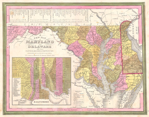
1846 Burroughs / Mitchell Map of Maryland & Delaware w/ Baltimore Inset
MD-burroughs-1846$180.00

Title
A New Map of Maryland and Delaware with their Canals, Roads & Distances.
1846 11.5 x 14.5 in (29.21 x 36.83 cm)
1846 11.5 x 14.5 in (29.21 x 36.83 cm)
Description
This scarce hand colored map is a lithographic engraving of Maryland and Delaware, dating to 1846 by the legendary American Mapmaker S.A. Mitchell, the elder. Includes a detailed inset map of Baltimore. This is a rare transitional map produced by the mysterious engraver H. N. Burroughs, whose work for the Mitchell firm appears in 1846 between that of H.S. Tanner and Mitchell himself. Ristow notes, 'Nothing is known about Burroughs, but he was undoubtedly an employee or associate of Mitchell.' His fine and detailed work appears only in the hard to find 1846 edition of the Mitchell's Atlas. Dated and copyrighted 1846.
Cartographer
Horatio Nelson Burroughs (June 28, 1812 - August 23, 1896) was an engraver and later a banker based in Pennsylvania and active in the early 19th century. He was born in Washington Crossing, New Jersey. Burroughs' work first appears in conjunction with Henry Schenk Tanner and Samuel Augustus Mitchell (the elder). His name appears on the 1846 copyrights of many of Mitchell's earliest and most important atlas and pocket maps. Following 1846, Burroughs retired from engraving to become a banker, eventually becoming president of Commonwealth Bank. He married first Eleanor Douglas Mitchell (18?? - 1853), then, after her untimely death, her sister Caroline Mitchell (1818 - 1892), both daughters of map and atlas publisher Samuel Augustus Mitchell Sr. (1792 - 1868). More by this mapmaker...
Condition
Very good condition. Minor discoloration around Annapolis and another near St. Johns Delaware.