This item has been sold, but you can get on the Waitlist to be notified if another example becomes available, or purchase a digital scan.
1730 Hendrik De Leth Map of the Americas and the Pacific
MerDuSud-deleth-1730$8,500.00

Title
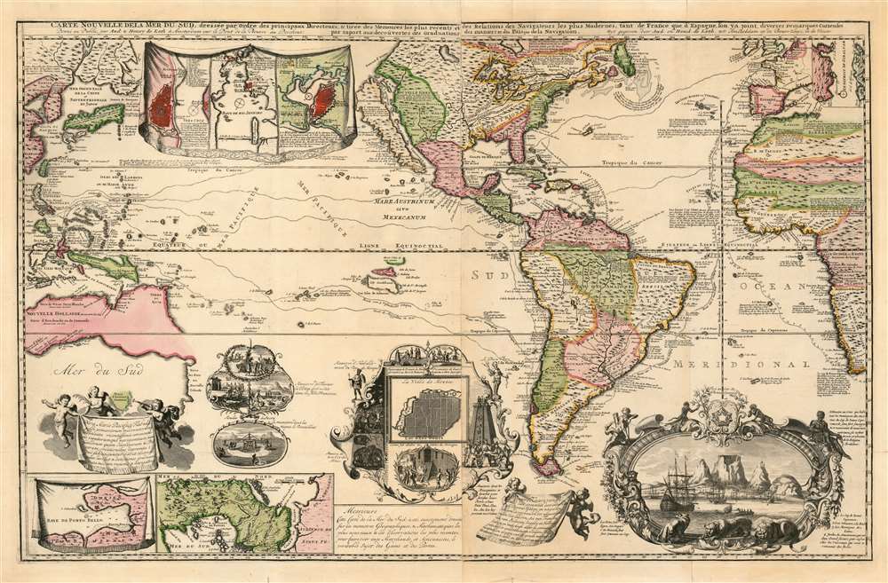
Carte Nouvelle de la Mer du Sud, dressee par Ordre des principaux Directeurs des Memoires les plus recents et des Relations des Navigateurs les plus Modernes.
1730 (undated) 23 x 36.5 in (58.42 x 92.71 cm) 1 : 30000000
1730 (undated) 23 x 36.5 in (58.42 x 92.71 cm) 1 : 30000000
Description
A superb example of a rare map, by Hendrik De Leth, presenting the reader with a compendium of European exploration and discovery. Not confined to the Pacific Ocean - as suggested by the title - the map includes richly detailed mapping of the Americas and coastal Africa as well as the Pacific, Southeast Asia, and Australia. Though it is clearly based in part on de Fer's map of 1713 and the 1719 Chatelain, this finely engraved map is easily the match of its predecessors for the elegance of its decorative vignettes. These include - along the bottom center of the map - scenes depicting the manner of turtle-hunting on Pacific Islands, the operation of a sugar mill, gold mining and bird hunting in Mexico, the manner of human sacrifice in mezo America, and a depiction of Cortez destroying Mexican idols. To the lower right is a magnificent scene of the Cape Town settlement, filled with ships and surrounded by a magnificent frame decorated with lions, monkeys, and native figures.
Inset Maps
The map's main map is supported by seven inset maps, detailing the Strait of Gibraltar, a plan of Mexico City, a map of Porto Bello, the Isthmus of Panama, plans of Vera Cruz and Havana, and a chart of the Bay of Rio de Janeiro.North America
In terms of place names and broad outline, the treatment of North America is similar to that which appears in the 1713 De Fer and the 1719 Chatelain. While the earlier maps are devoid of topographical detail, De Leth errs far in filling the continent with mountains. The Great Lakes are shown with good detail (including the briefly-fashionable Lac Superior de Tracy The Mississippi is shown to have as its source a spurious lake in (mountainous) central Canada. (On both the De Fer and Chatelain, that part of North America is occupied by portraits of great circumnavigators.) In common with its predecessor maps, De Leth's map puts the mouth of the Mississippi in the Gulf Coast of Texas.Insular California Called Repeatingly Into Question
The map presents a prominent island of California, despite the map of Jesuit Eusebio Kino refuting the myth having been in circulation for more than twenty five years. It does, however, bear a legend noting the modern notion that the island was connected to North America.The Voyagers
Among the characteristic features of this map are the tracks of transatlantic and transpacific voyages, including that of Le Maire and Schouten, Magellan, and the Manila Galleons.Australia
De Leth follows De Fer - but not Chatelain - in his treatment of Australia. Tooley notes:A rare map with a curious representation for Australia. Tasman’s outline and names are followed but the south coast is continued far to the East joining on to New Zealand, but a strait is left between Carpentaria and New Guinea, and a floating Terre de Quir[os] forming an east coast to the continent.
Silence on the North Pacific
Where the De Fer and Chatelain display a Terre d'Anian in the Pacific Northwest, and a Terre de la Compagnieoff the coast of northeastern Asia, the De Leth dispenses with both of these imaginary places, obscuring the space between with a trio of city views. The Terre de Jesso is shown as a definite part of the Asian mainland, rather than as part of the Japanese archipelago. Korea is shown as a peninsula. The sea between Japan and Korea is here dually referred to as Mer Orientale de la Chine et Septentrionale du Japon.Publication History and Census
The map did not appear in De Leth's geographical and historical atlas, and is considered to be a separate issue. Some surviving examples appear to have been included in R. & J. Ottens' 'Atlas sive geographia compendiosa' as well as Covens and Mortier's 'Nieuwe atlas.' OCLC lists examples in eleven institutional collections.Cartographer
Hendrik de Leth (May 31, 1703 - June 17, 1766) was a Dutch print artist, etcher, engraver, mapmaker, draftsman, bookseller, art dealer, print publisher, art collector, and naturalist. He was the son of Andries de Leth (also an engraver and bookseller, 1662-1731) He trained under his father, and joined the bookseller's guild at the age of 25. The elder De Leth had taken over the Visscher mapmaking business after the death of Nicholas II, and, Hendrik de Leth in turn took over after the death of his father. De Leth would be better known perhaps for his prints than his maps, though he produced a geographical atlas and historical atlas in 1740. More by this mapmaker...
Condition
Very good. Marginal mends at folds; and some reinforced areas of brittleness due to age of color. One filled wormhole not affecting printed image. Superb contemporary color.
References
OCLC 50594473. Norwich Map 320; Tooley, MCS No. 6, no. 11; McLaughlin 220, state 3; Leighly 169; Tooley, Australia, pp. 213-14.