This item has been sold, but you can get on the Waitlist to be notified if another example becomes available, or purchase a digital scan.
1935 Miguel Gómez Medina Pictorial Map of Mexico City (DF), Mexico
MexicoCity-miguelgomezmedina-1935$925.00

Title
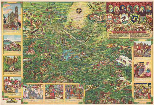
Mapa Pintoresco del Distrito Federal y Alrededores. Pictorial Map of the Federal District and Surroundings.
1935 (undated) 25.5 x 37.5 in (64.77 x 95.25 cm)
1935 (undated) 25.5 x 37.5 in (64.77 x 95.25 cm)
Description
Issued during the Golden Age of Pictorial Maps (c. 1920 - 1960), this is a wonderful whimsical map of the Valley of Mexico City (DF, Distrito Federal) by Mexican artist Miguel Gómez Medina. Although not drawn to scale, the map centers on the lake of Xochimilco and extends north as far as the majestic ruins of Teotihuacan, and as far as the volcano Popocatépetl. The grid structure of the Centro Histórico and the Zócalo are obvious just to the north of the lake. Cartoon illustrations throughout focus on Mexican life and culture but also include highways and railroads – indications that Mexico is both rich in culture and rapidly embracing modern technological developments. The map proper is surrounded by scenes from Mexican life, including a street view of Cuernavaca, a village market, the Nevado de Toluca, the Convento de Tepotzotlan, and a night scene in the Zócalo during Mexican Independence Day La Noche de 'El Grito', among other scenes.
Publication History and Census
This is probably the rarest and certainly among the finest of Miguel Gómez Medina's pictorial maps. Most date the map to 1930, but we have traced a copyright record filed by the publisher, Eugenio Fischgrund, in the United States definitively dating the map to November 11, 1935. This map was printed in Mexico by F. Sanchez. We are aware of only one example in an institutional collection at Stanford University. This map is rare to the market.CartographerS
Miguel Gómez Medina (fl. c. 1930 – 1960) was a Mexican illustrator and graphic artist active in the first half of the 20th century to about 1960. Gomez is the most significant Mexican proponent of the Golden Age of Pictorial Mapmaking (c. 1920 – 1960) with several significant large format pictorial maps of various parts of Mexico and Guatemala to his name. Medina was a versatile artist capable of work in a variety of different styles, with some of his work being akin to English pictorial map pioneer MacDonald Gill and other pieces reminiscent of the French illustrator Lucian Boucher. In addition to large format poster maps, Medina also issued map postcards, including one of Guatemala and another of Canada. Medina's maps and postcards were typically published by Athenaeum Fischgrund Publishing. Little is known of Medina's personal life. More by this mapmaker...
Eugenio Fischgrund (1905 - 1980) was a travel writer and publisher of posters, books and postcards active in Mexico City. Fischgrund owned several imprints, including Athenaeum Fischgrund Publishing, which he founded c. 1930, and Editorial de Arte. He was also one of the first to publish and distribute prints of works by Mexican artists in the United States. Some of his artists included Diego Riviera (1886 – 1957), Charles X. Carlson (1902–1991), F. Lugo, Rafael Martínez Padilla (1878–1958), and Miguel Gomez Medina. Learn More...
Condition
Very good. Closed tear extending one inch into printed area from left margin professionally repaired on verso. Blank on verso.
References
Rumsey 8720.000. OCLC 953572589.