This item has been sold, but you can get on the Waitlist to be notified if another example becomes available, or purchase a digital scan.
1845 Radefeld Map of Mexico and the Republic of Texas
MexicoTexas-radefeld-1845$375.00

Title
Neueste Karte von Mexico.
1845 (dated) 12.25 x 15.25 in (31.115 x 38.735 cm) 1 : 11200000
1845 (dated) 12.25 x 15.25 in (31.115 x 38.735 cm) 1 : 11200000
Description
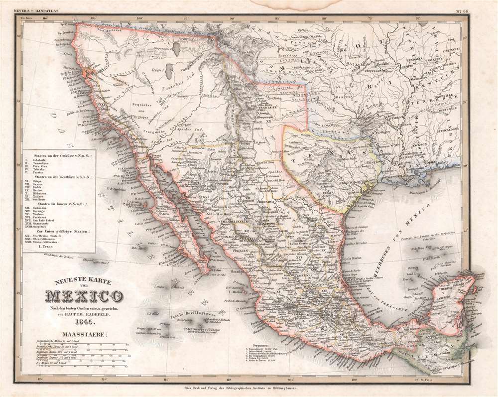
This is an 1845 Carl Radefeld map of Mexico and the Republic of Texas. Published on the eve of the Mexican-American War (1846 - 1848), Mexico stretches from Oregon to Guatemala, the border of the 1819 Adams-Onís Treaty. The Republic of Texas appears in one of its smallest border configurations, suggesting that the German cartographers were sympathetic to Mexico's arguments about Texas's rightful borders and not the more expansive borders advocated by Texans. Rivers are labeled throughout, including the Colorado, Nueces, and Rio Grande. Two mythical rivers, the Buenaventura and Francisco, are also identified, and two great salt lakes illustrated. San Antonio, Santa Fe, Albuquerque, Mexico City, and Veracruz are named, along with numerous other cities and towns. Mexican states are labeled using Roman numerals corresponding with an index along the left border.
Republic of Texas
The Republic of Texas was a short-lived nation established in March of 1836 when it ceded from Mexico. Following the independence of Mexico from Spain, the American Stephen Fuller Austin led a group of 300 Empresarios to settle Texas, near Austin, where they received a grant from the Mexican government. As more Americans moved to Texas, resentment and strife began to build between the American settlers and Mexican authorities. This and other factors ultimately led to the Texan Revolution in 1835 and the declaration of Texan independence in 1836. Texas remained an independent republic until it joined the United States 10 years later in 1846.Texas Borders
The borders of the Republic of Texas were in dispute from the earliest days of the Texan Revolution. The Republic-claimed borders followed the Treaties of Velasco between the newly created Texas Republic and Mexican leader, Antonio López de Santa Anna. The treaties established an eastern boundary following the 1819 Adams-Onís Treaty between the United States and Spain, which established the Sabine River as the eastern boundary of Spanish Texas and western boundary of the Missouri Territory. The Republic's southern and western boundary with Mexico was more nuanced. Texas claimed the Rio Grande del Norte as its western and southernmost border, while Mexico argued for a boundary much further east at the Nueces River. When Texas was annexed into the United States, the agreement followed the Republic claimed boundary, thus absorbing Mexican claimed territory as far west as Santa Fe. This escalated already existing tensions between the United States, the former Republic of Texas, and Mexico, ultimately triggering for the Mexican-American War (1846 -1848).Publication History and Census
This map was created by Carl Radefeld and published by Joseph Meyer in his Grosser Hand-Atlas in 1845. We note a single cataloged example of the separate map in OCLC which is part of the collections at the University of Michigan. An example of the complete atlas is part of the David Rumsey Map Collection.CartographerS
Carl Christian Franz Radefeld (1788 - 1874) was a German lawyer and cartographer. Radefeld was born in Jena, Germany, where he studied law and theology and began working as a lawyer in 1811. He became interested in cartography in the 1840s when he became involved with map and atlas publisher Joseph Meyer (1796 - 1856). From 1846, he contributed maps to Meyer's Groẞer Hand-Atlas (1843 - 1860). More by this mapmaker...
Joseph Meyer (May 9, 1796 - June 27, 1856) was a German industrialist, merchant, and publisher, active in Germany in the early to mid 19th century. He is best known for publishing the encyclopedia Meyers Conversation-Lexicon. Born in Gotha, Germany, Meyer was educated as a merchant in Frankfurt am Main. He moved to London in 1816, but returned to Germany in 1820 after his stock speculations and business adventures fell through. Once back in Germany, he began by investing in the textile trade (1820 - 24). Meyer began creating business plans concerning how to start railways soon after the first steam-hauled railway began operation in December 1835. He founded the Deutsche Eisenbahnschienen-Compangie auf Actien (German Railway Rail joint stock company) in 1845. Meyer also found great success as a publisher, utilizing the system of serial subscriptions to publications, a new idea for the time. He founded a company, Bibliographisches Institut in Gotha in 1825, which published several versions of the Bible, works of classical literature, atlases, the world in pictures on steel engravings, and an encyclopedia. He moved the Institut from Gotha to Hildburghausen in 1828. He published several atlases, including Meyer's Groẞer Hand-Atlas (1843 - 1860). In 1848, he supported the Springtime of the Peoples Revolutions that took place throughout Germany and much of Europe. When the revolutions failed in 1849, Meyer was briefly imprisoned for his support of revolutionary activities. The revolutions also began to take a toll on Meyer's business interests, and when he died, in 1856, the Bibliographisches Institut was struggling financially. His son, Herrmann Julius Meyer, took over the firm, spearheading a rapid recovery. This, and other businesses prospered under Herrmann Julius (April 4, 1826 - March 12, 1909) and when he died in 1909, he led the richest family in Saxony, with more total wealth than the King of Saxony Learn More...
Source
Meyer, Joseph, Grosser Hand-Atlas, 1845.
Condition
Very good. Dampstaining in upper margin.
References
Rumsey 4807.167. OCLC 878506292.