This item has been sold, but you can get on the Waitlist to be notified if another example becomes available, or purchase a digital scan.
1851 Tallis Map of Mexico, Texas & California
MexicoTexas-tlls-1851$275.00

Title
United States.
1851 10 x 13.5 in (25.4 x 34.29 cm)
1851 10 x 13.5 in (25.4 x 34.29 cm)
Description
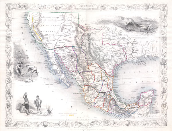
This is John Tallis's highly desirable 1851 Map of Mexico, Texas and Upper California. Herein Texas is depicted at its fullest extent including both Santa Fe and the Green Mountains. Upper California offers numerous interesting features, most specifically a colored and labeled Gold Region extending along the Sacramento River as far south as an oversized Lake Tule and Santa Cruz. The 'Great Caravan Route' used by covered wagons during the westward expansion is also noted. Offers several beautiful vignettes depicting the Ruins at Uxmal, Yucatan, panning gold in California, and Mexican Peasantry. Undated, but the defined gold regions allows us to identify this as the 1851 issued of Tallis's valuable map.
Cartographer
John Tallis and Company (1838 - 1851) published views, maps, and atlases in London from roughly 1838 to 1851. Their principal works, expanding upon the earlier maps of John Cary and Aaron Arrowsmith, include an 1838 collection of London Street Views and the 1849 Illustrated Atlas of the World. The firm’s primary engraver was John Rapkin, whose name and decorative vignettes appear on most Tallis maps. Due to the embellishments typical of Rapkin's work, many regard Tallis maps as the last bastion of English decorative cartography in the 19th century. Although most Tallis maps were originally issued uncolored, it was not uncommon for 19th century libraries to commission colorists to "complete" the atlas. The London Printing and Publishing Company of London and New York bought the rights for many Tallis maps in 1850 and continued issuing his Illustrated Atlas of the World until the mid-1850s. Specific Tallis maps later appeared in innumerable mid to late-19th century publications as illustrations and appendices. More by this mapmaker...
Condition
Fine or perfect condition. Blank on verso.
References
Phillips, 804-71.; Rumsey, 0466.072.