This item has been sold, but you can get on the Waitlist to be notified if another example becomes available, or purchase a digital scan.
1719 Chatelain Map and View of Mexico City, Mexico
Mexique-chatelain-1719$625.00

Title
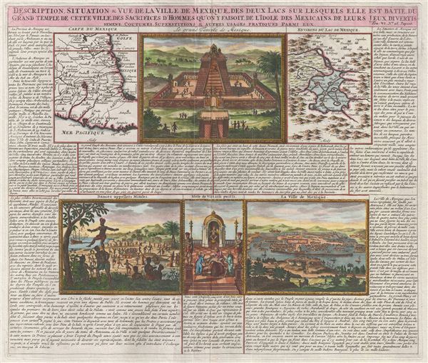
Description, Situation & Vue de la Ville de Mexique, des Deux Lacs sur lesquels elle est Batie, du Grand Temple de cette Ville, des Sacrifice d'Homme qu'on y Faisoit, de l'Idole des Mexicains, de Leurs Jeus Divertis semens, Coutumes, Superstitions & Atures Usages Pratiques Parmi Eux.
1719 (undated) 15 x 17.5 in (38.1 x 44.45 cm)
1719 (undated) 15 x 17.5 in (38.1 x 44.45 cm)
Description
An exceptionally beautiful example of Abraham Chatelain's 1719 map and view sheet focusing on Mexico. This sheet combines two maps and four engraved views with extensive text describing the lands and customs of Mexico. The maps, appearing in the upper right and left quadrants detail central Mexico and Mexico City. The more general maps, located in the upper left, is centered on Mexico City and details from the Gulf of Mexico to the Pacific and from the Rio de Palmas to Acapulco. The second map, in the upper right, focuses more specifically on Mexico City, revealing the ancient Lake Texcoco, and the cultivated islands that once housed the great Aztec capital. Between the two maps a large view depicts a typical Aztec temple complex. The lower views detail, from left, traditional Aztec dances with a Spanish galleon in the background, human sacrifice, and a general view of Mexico City combining european and Aztec architectural elements. The extensive surrounding text, in French, attempt to describe the customs, peoples, resources, and geography of Mexico. Prepared by Abraham Chatelain and engraved by Bernard Picart for inclusion in his 1719 Atlas Historique.
Cartographer
Henri Abraham Chatelain (1684 - 1743) was a Huguenot pastor of Parisian origins. He lived consecutively in Paris, St. Martins, London (c. 1710), The Hague (c. 1721) and Amsterdam (c. 1728). He is best known as a Dutch cartographer and more specifically for his cartographic contribution in the seminal seven volume Atlas Historique, published in Amsterdam between 1705 and 1720. Innovative for its time, the Atlas Historique combined fine engraving and artwork with scholarly studies of geography, history, ethnology, heraldry, and cosmography. Some scholarship suggests that the Atlas Historique was not exclusively compiled by Henri Chatelain, as is commonly believed, but rather was a family enterprise involving Henri, his father Zacharie and his brother, also Zacharie. More by this mapmaker...
Source
Chatelain, A. H., Atlas Historique, (Amsterdam: L'Honoré & Châtelain), vol 4, 1719.
Condition
Very good. Orignal centerfold. Wide clean margins.
References
Phillips, P.L. (Atlases) 548, v.6, no.28.