This item has been sold, but you can get on the Waitlist to be notified if another example becomes available, or purchase a digital scan.
1829 Lapie Map of Mexico, Texas, and Upper California
Mexique-lapie-1829$225.00

Title
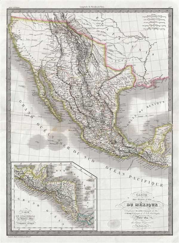
Carte des Etats-Unis du Mexique.
1829 (dated) 21.5 x 16 in (54.61 x 40.64 cm)
1829 (dated) 21.5 x 16 in (54.61 x 40.64 cm)
Description
A beautiful but little known 1829 first edition map of Mexico and its pre-1849 North American claims in Upper California and Texas by Emile Lapie. The map covers all of Mexico from Cape San Sebastian and the Missouri River south to include modern day Mexico, the Yucatan, and, via inset, Central America. Lapie's map offers fine detail throughout with elevation rendered by hachure and political boundaries demarcated with outline hand color.
The 1820s and 30s continental Europe saw an extraordinary explosion of interest the American southwest, particularly Texas, where French and German settlements were beginning to appear. Cartographers in europe, like Lapie, were quick to respond. This map by Lapie is one of the most beautiful continental european maps of the American southwest to appear in the 1830s.
Loosely based on an earlier map of the same region by Brue, another French cartographer, Lapie's map incorporates elements from Alexander von Humboldt's map of 1811 as well as the explorations of American military men Zebulon Pike and Stephen Harriman Long. The abandoned French settlement of Champ d'Axile in eastern Texas, then a part of the intendancy of San Luis Potosi, is noted. Further north, the Great Basin exhibits cartography reminiscent of the escalante expedition with Great Salt Lake (L. Timpanagos) and Utah Lake (L. Teguayo) connecting to the Pacific via the apocryphal rivers Millers and Buenaventura. Lapie indicates the Santa Fe Trail from St. Louis to Santa Fe. No trace of the Sierra Nevada range or the discoveries of the fur trader Jedediah Smith is in evidence.
This map was engraved by Armand Joseph Lallemand as plate no. 44 in the first edition of M. Lapie's important Atlas Universel. This map, like all maps from the Atlas Universel features an embossed stamp from the Lapie firm.
CartographerS
Pierre M. Lapie (fl. 1779 - 1850) and his son Alexandre Emile Lapie (fl. 1809 - 1850) were French cartographers and engravers active in the early part of the 19th century. The Lapies were commissioned officers in the French army holding the ranks of Colonel and Capitan, respectively. Alexander enjoyed the title of "First Geographer to the King", and this title appears on several of his atlases. Both father and son were exceptional engravers and fastidious cartographers. Working separately and jointly they published four important atlases, an 1811 Atlas of the French Empire (Alexander), the 1812 Atlas Classique et Universel (Pierre), the Atlas Universel de Geographie Ancienne et Modern (joint issue), and the 1848 Atlas Militaire (Alexander). They also issued many smaller maps and independent issues. All of these are products of exceptional beauty and detail. Despite producing many beautiful maps and atlases, the work of the Lapie family remains largely underappreciated by most modern collectors and map historians. The later 19th century cartographer A. H. Dufour claimed to be a student of Lapie, though it is unclear if he was referring to the father or the son. The work of the Lapie firm, with its precise engraving and informational density, strongly influenced the mid-19th century German commercial map publishers whose maps would eventually dominate the continental market. More by this mapmaker...
Armand Joseph Lallemand (c. 1810 - 1871) was an engraver and map publisher based in Paris during the mid-19th century. Most of Lallemand's work focused on landscapes and building vies, though he did take part in a few cartographic ventures, including the production of an atlas with Alexandre Emile Lapie and several tourist pocket maps of Paris. Learn More...
Source
Lapie, M., Atlas Universel de Geographie. Ancienne et Moderne, precede d'un Abrege de Geographic Physique et Historique…, 1829. (Rumsey identifies this as the first edition of Lapie's Atlas Universel. In all known examples, the title page is dated 1829 while the maps are dated variously to 1833 - suggesting that the first issue of this atlas was 1833, not 1829.)
Condition
Very good. Original platemark visible. Blank on verso. Original centerfold.
References
Phillips (Atlases) 754, 765. Kapp, K.S. The Printed Maps of Central America up to 1860, 2 vols, #108. Bancroft Library G4410 1842 L3 (1842 ed.).