This item has been sold, but you can get on the Waitlist to be notified if another example becomes available, or purchase a digital scan.
1852 Noble Land Survey Map of Michigan
Michigan-noble-1852$125.00

Title
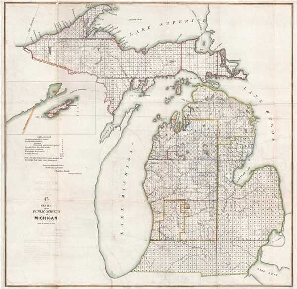
G Sketch of the Public Surveys in Michigan.
1852 (dated) 21.75 x 22.5 in (55.245 x 57.15 cm) 1 : 1140480
1852 (dated) 21.75 x 22.5 in (55.245 x 57.15 cm) 1 : 1140480
Description
This is an 1852 Charles Noble land survey map of Michigan. The map depicts the state from Lake Superior to Lake Erie, Ohio, Indiana, and Illinois and from Wisconsin to Lake Huron. Illustrating the current status of the land survey in Michigan, each township is labeled throughout the entire state is labeled according to its status. The township was created as the measure of the Public Land Survey System, which was first widely implemented to survey the Northwest Ordinance. The Public Land Survey System allowed for the systematic surveying and mapping of any territory gained by the United States. A table explaining the various different notations is situated along the left border, below an inset of Isle Royale. Highly detailed, the township grid is labeled, allowing for easy identification of any specific township. Lakes, rivers, and points along the coast of the Upper Peninsula are labeled. Lake Michigan is illustrated in its entirety, along with part of Lake Superior, Lake Huron, and Lake Erie. We also have a Land Survey map of Michigan from 1855, which allows for an intriguing glimpse into the progress of survey work in Michigan during these years.
This map was produced by the Public Land Survey in 1852 and approved by Charles Noble, the Surveyor General.
This map was produced by the Public Land Survey in 1852 and approved by Charles Noble, the Surveyor General.
Cartographer
The General Land Office (1812 - 1946) was an independent agency charged with the administration and sale of public lands of the western territories of the United States under the Preemption Act of 1841 and the Homestead Act of 1862. During a time of frenetic energy and rapid westward expansion, the Land Office oversaw the surveying, platting, mapping and eventually the sale of much of the Western United States and Florida. The structural layout of the western United States that we see today, and many of their district and county divisions, are direct result of the early surveying work of the General Land Office. More importantly, as a branch of the Federal Government in Washington D.C. and the only agency able to legally sell and administer public lands in the western territories of the United States, the General Land Office played a pivotal role in consolidating power away from the original states and into the hands of the centralized federal government. The General Land Office was absorbed into the Department of Interior in 1849 and in 1946 merged with the United States Grazing Service to become the Bureau of Land Management. Today the Bureau of Land Management administers the roughly 246 million acres of public land remaining under federal ownership. More by this mapmaker...
Source
Report of the Commissioner of the General Land Office, (Washington) 1852.
Condition
Very good. Even overall toning. Backed on archival tissue for stability. Blank on verso.
References
OCLC 83623351.