This item has been sold, but you can get on the Waitlist to be notified if another example becomes available, or purchase a digital scan.
1846 Meyer Map of the Middle East, Persia, Afghanistan, Central Asia
MiddleEast-meyer-1846$87.50

Title
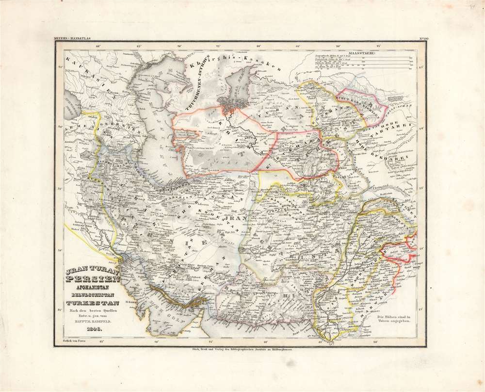
Jran, Turan, Persien, Afghanistan, Beludschistan, Turkestan.
1846 (dated) 11.5 x 14 in (29.21 x 35.56 cm) 1 : 9500000
1846 (dated) 11.5 x 14 in (29.21 x 35.56 cm) 1 : 9500000
Description
This is Carl Radefeld's appealingly hand-colored 1846 map of the Middle East and Central Asia, produced for Meyer's Grosser Hand-Atlas. It depicts the region as both British and Russian influence were increasing, setting off the 'Great Game' competition between the two empires.
'The Great Game' was a diplomatic confrontation between the British and Russian Empires over Afghanistan and other territories in Central and Southern Asia. Russia feared Britain was making commercial and military inroads into Central Asia, an area long within the sphere of influence of St. Petersburg. Britain, conversely, feared Russia making gains in India, 'the jewel in the crown' of British Asia. The escalating tensions led to several wars and proxy wars: The First Anglo-Afghan War, the First Anglo-Sikh War (1845 - 1846), the Second Anglo-Sikh War (1848 - 1849), and the Second Anglo-Afghan War (1878 - 1880), along with the Russian annexations of Khiva, Bukhara, and Kokand. In the 1870s-1890s, a series of diplomatic agreements gradually settled British and Russian spheres through the regions represented here, but distrust and tensions remained well into the 20th century.
A Closer Look
Coverage extends from the Caucuses to Tibet, taking in the modern nation-states of Iran, Pakistan, Afghanistan, and the Central Asian states. Cities, roads, and geographic features are marked, including terrain such as the Dasht-e Kavir, the great salt desert (Salz Wüste) of Persia. The borders of the region empires, khanates, and other territories are outlined in different colors to allow for their easy distinction. Scales are provided in geographic or German miles, French leagues, Turkish miles (fersah فرسخ, roughly equivalent to the Persian parasang), and nautical miles.The Great Game
This map was made in the wake of important conflicts that set the stage for a wide-ranging imperial competition between Russia and Britain. Russia had defeated Persia in two wars and established itself as the dominant power in the Caucasus. Meanwhile, the Afghan Durrani Empire was conquered by the Sikhs, who in turn were subjugated by the British. A new Afghan Emirate (the Barakzai dynasty) arose and was quickly caught between Russian and British intrigues, dealing the British a stunning defeat in the First Anglo-Afghan War (1838-1842). Russia's early forays into Central Asia did not fare much better, with an 1839 expedition against Khiva ending in disaster. But, like the British, by the 1850s-1860s, the growing military disparity between Russia and its opponents made Russian victory nearly a foregone conclusion.'The Great Game' was a diplomatic confrontation between the British and Russian Empires over Afghanistan and other territories in Central and Southern Asia. Russia feared Britain was making commercial and military inroads into Central Asia, an area long within the sphere of influence of St. Petersburg. Britain, conversely, feared Russia making gains in India, 'the jewel in the crown' of British Asia. The escalating tensions led to several wars and proxy wars: The First Anglo-Afghan War, the First Anglo-Sikh War (1845 - 1846), the Second Anglo-Sikh War (1848 - 1849), and the Second Anglo-Afghan War (1878 - 1880), along with the Russian annexations of Khiva, Bukhara, and Kokand. In the 1870s-1890s, a series of diplomatic agreements gradually settled British and Russian spheres through the regions represented here, but distrust and tensions remained well into the 20th century.
Publication History and Census
This map was engraved, printed, and published by Carl Radefeld of the Bibliographisches Institut in Hildburghausen, a company founded by Joseph Meyer. It appeared as map No. 100 in Meyer's Grosser Hand-Atlas, a landmark work of mid-19th century German cartography. Although the map itself is dated as 1846, the Grosser Hand-Atlas was not published and distributed until 1860. This map is only independently cataloged among the holdings of three institutions, while Meyer's Grosser Hand-Atlas is held by perhaps a dozen institutions in North America and Europe.CartographerS
Joseph Meyer (May 9, 1796 - June 27, 1856) was a German industrialist, merchant, and publisher, active in Germany in the early to mid 19th century. He is best known for publishing the encyclopedia Meyers Conversation-Lexicon. Born in Gotha, Germany, Meyer was educated as a merchant in Frankfurt am Main. He moved to London in 1816, but returned to Germany in 1820 after his stock speculations and business adventures fell through. Once back in Germany, he began by investing in the textile trade (1820 - 24). Meyer began creating business plans concerning how to start railways soon after the first steam-hauled railway began operation in December 1835. He founded the Deutsche Eisenbahnschienen-Compangie auf Actien (German Railway Rail joint stock company) in 1845. Meyer also found great success as a publisher, utilizing the system of serial subscriptions to publications, a new idea for the time. He founded a company, Bibliographisches Institut in Gotha in 1825, which published several versions of the Bible, works of classical literature, atlases, the world in pictures on steel engravings, and an encyclopedia. He moved the Institut from Gotha to Hildburghausen in 1828. He published several atlases, including Meyer's Groẞer Hand-Atlas (1843 - 1860). In 1848, he supported the Springtime of the Peoples Revolutions that took place throughout Germany and much of Europe. When the revolutions failed in 1849, Meyer was briefly imprisoned for his support of revolutionary activities. The revolutions also began to take a toll on Meyer's business interests, and when he died, in 1856, the Bibliographisches Institut was struggling financially. His son, Herrmann Julius Meyer, took over the firm, spearheading a rapid recovery. This, and other businesses prospered under Herrmann Julius (April 4, 1826 - March 12, 1909) and when he died in 1909, he led the richest family in Saxony, with more total wealth than the King of Saxony More by this mapmaker...
Carl Christian Franz Radefeld (1788 - 1874) was a German lawyer and cartographer. Radefeld was born in Jena, Germany, where he studied law and theology and began working as a lawyer in 1811. He became interested in cartography in the 1840s when he became involved with map and atlas publisher Joseph Meyer (1796 - 1856). From 1846, he contributed maps to Meyer's Groẞer Hand-Atlas (1843 - 1860). Learn More...
Source
Meyer, J., Grosser Hand-Atlas uber alle Theile der Erde in 170 Karten, (Hildburghausen: Verlag des Bibliographischen Instituts) 1860.
Condition
Very good. Light foxing and ink smudges in margins.
References
Rumsey 4807.109. OCLC 1108660222, 632619875.