This item has been sold, but you can get on the Waitlist to be notified if another example becomes available, or purchase a digital scan.
1875 Beers Map of the Midwest (Wisconsin, Iowa, Missouri, Illinois, Indiana, Michigan)
Midwest-beers-1876$75.00

Title
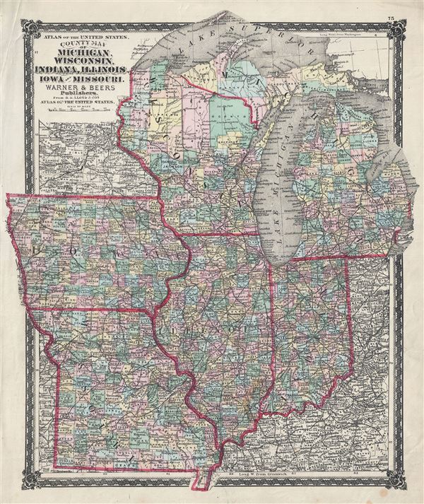
County Map of Michigan, Wisconsin, Indiana, Illinois, Iowa and Missouri.
1876 (undated) 17 x 14 in (43.18 x 35.56 cm) 1 : 3200000
1876 (undated) 17 x 14 in (43.18 x 35.56 cm) 1 : 3200000
Description
A fine 1876 map of the American Midwest by Warner and Beers. It covers the states of Michigan, Wisconsin, Indiana, Illinois, Iowa and Missouri and includes Lake Michigan and part of Lake Superior. The map is highly detailed and notes cities, railroads, counties, rivers and a host of additional topographical features. Indian tribes are noted in Wisconsin. This map was published by Warner and Beers for H.H. Lloyd and Company's Atlas of the United States.
Cartographer
The Beers family (Fredrick, Silas, James and Daniel) (fl. c. 1850 - 1886), along with Charles and Augustus Warner, were prominent map publishers working from the 1850s to the late 1880s. Often publishing under the Warner & Beers designation, the combined firms produced a series of important state and county atlases and map of much of the northeastern United States. Many of their regional maps are among the most detailed and well laid out maps ever produced of their respective regions. Because Warner & Beers county maps were often detailed down to the individual homes and landowners, they have become highly sought after by general and family historians. In additional to producing maps of surpassing detail, Warner & Beers also maintained an earlier generation's attention to detail and quality while publishing in an era ever increasingly dominated by the low cost printing methods used by the publishing empires of Rand McNally and George Cram. More by this mapmaker...
Source
Lloyd, H. H., Atlas of the United States, 1876.
Condition
Very good. Blank on verso. Minor spotting.