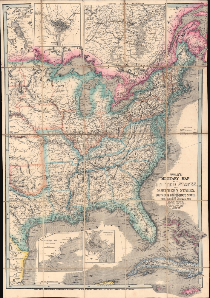
1861 Wyld Map of the United States during the Civil War
MilitaryMapUnitedStates-wyld-1861$3,000.00


Title
Wyld's Military Map of the United States, the Northern States, and the Southern Confederate States, with the Forts, Harbours, Arsenals, and Military Positions.
1861 (dated) 35 x 24.5 in (88.9 x 62.23 cm) 1 : 4500000
1861 (dated) 35 x 24.5 in (88.9 x 62.23 cm) 1 : 4500000
Description
A rare James Wyld map of the United States issued in 1861, during the Secession Crises that preceded the outbreak of the American Civil War (April 1861 - 1865). Wyld was particularly masterful at capturing political events throughout the world as they happened and leveraging his impressive publishing operation to quickly produce and distribute pertinent to the invested public. In this case, the map distinguishes between the 'Northern States' (orange border) and the 'Southern Confederate States' (blue border). Wyld here erroneously conflates slaveholding states with Confederate secessionist states - in particular, Missouri, Kentucky, Delaware, and Maryland, which allowed slavery but remained loyal to the Union. Arsenals, forts, and military posts highlighted and keyed, underscoring that 'war' was very much in the air. The map is also noteworthy for recognizes the apocryphal territory 'Chippewa', roughly corresponding to modern-day North Dakota.
1860/61 American Secession Crises
This map was published in early 1861, just prior to the outbreak of the American Civil War, but after the majority of southern states had issued articles of secession, forming the Confederate States of America. Leading up to the 1860 Presidential Election, there had long been tension between the northern and southern states over the issue of slavery. Southern states, with a powerful slavery-based plantation culture, relied on slavery as the basis of their economic and social system. Northern states, most of which were industrialized, had long since abolished slavery, and most considered the practice abhorrent. Abraham Lincoln (1809 - 1865), although not strictly an abolitionist, was morally opposed to slavery and spoke openly against it on the campaign trail. His election in November of 1860 lead to the December secession of South Carolina - the most vocal 'states-rights' pro-slavery state. The 'cotton states' of Mississippi, Florida, Alabama, Georgia, Louisiana, and Texas followed suit, seceding in January and February 1861, forming the Confederate States of America this case relying more on February 4, 1861. When Wyld issued this map, Arkansas, Tennessee, North Carolina, and Virginia had yet to secede.British Interest in the Secession
The rise of the Confederacy and the impending American Civil War was briefly a matter of the greatest interest in England. On one hand, most British citizens deplored the practice of slavery, which had been abolished in the British Empire since 1833. On the other hand, the large and influential British textile industry relied heavily on cotton imports from the southern states and there was legitimate concern that failure to recognize the Confederate secession would disrupt supply and lead to economic instability. They were right and the subsequent Lancashire Cotton Famine (1861 - 1865) corresponded exactly with the Civil War. (Within a year Lancashire mill workers went from being the most prosperous in Britain to the most impoverished.) This map would have been of the utmost interest to parties on both sides of the debate. Ultimately, although a near thing, the British Parliament never recognized the Confederacy.Class Distinctions in Britain and Support for the Confederacy
Sympathies in Britain towards the American Civil War were generally broken down according to class and social rank. Quoting historian Douglas Gardner in his review of R. J. M. Blackett's Divided Hearts: Britain and the American Civil War,The more conservative - and Conservative - members of British society, drawn mostly from the aristocracy and the upper reaches of the middle classes, tended to be supporters of the Confederacy in the American conflict and scornful of the possibilities of liberalism or democracy at home. Many of the spokespeople for this group accepted and publicized the Southern apology for slavery as the basis of a properly hierarchical society. Those in the middle - Liberals whose spokespeople often were dissenting ministers or members of the growing professional groups - tended to support the Union but held and displayed a variety of views on race, slavery, and democracy. Working-class spokespeople tended to abhor slavery as another system of human exploitation, and they for the most part stood firm to these beliefs even during the Cotton Famine and other war-related economic dislocations. Less certain was the loyalty of workers (as opposed to their spokespeople) to the antislavery cause.
Chippewa
This is one of the few states that illustrate the 'Chippewa', an apocryphal state or territory roughly corresponding to modern-day North Dakota and eastern Montana. The idea for the state emerged in March of 1861, following the statehood of Minnesota and the creation of Dakota Territory. Proponents argued that Dakota was too large and should be divided into smaller territories. They claimed that, although somewhat barren, 'Chippewa' would benefit from tourism when the Northern Pacific Railroad was built. Due to the Civil War and other factors, this did not happen until 1883. We are aware of only 2 maps that illustrate the territory of Chippewa, both by Wyld, both dated 1861.Wyld's News Maps
Wyld was particularly masterful at capturing political events throughout the world as they happened and leveraging his impressive publishing operation to quickly produce and distribute pertinent maps to the invested public. The speed with which Wyld was able to assess news events and produced an informative and new fully engraved map contributed significantly to his commercial success. Wyld's news maps, while a small subset of his large cartographic corpus, arguably represent his most significant work - forming a vital record of currently developing new events from an even-handed if Anglo-centric perspective. Such maps had an ephemeral period of interest, were separately issued, and necessarily printed in small quantities, leading to their extreme scarcity today.Publication History and Census
This map was published in March of 1861 in London by James Wyld. This map is scarce to the market. We note institutional holdings at the Boston Public Library, the Library of Congress, Bibliothèque nationale de France, the David Rumsey Collection, among others.Cartographer
Wyld (1823 - 1893) was a British publishing firm active throughout the 19th century. It was operated by James Wyld I (1790 - 1836) and his son James Wyld II (November 20, 1812 - 1887) were the principles of an English mapmaking dynasty active in London during much of the 19th century. The elder Wyld was a map publisher under William Faden (1749 - 1836) and did considerable work on the Ordinance Survey. On Faden's retirement in 1823, Wyld took over Faden's workshop, acquiring many of his plates. Wyld's work can often be distinguished from his son's maps through his imprint, which he signed as 'Successor to Faden'. Following in his father's footsteps, the younger Wyld joined the Royal Geographical Society in 1830 at the tender age of 18. When his father died in 1836, James Wyld II was prepared to fully take over and expand his father's considerable cartographic enterprise. Like his father and Faden, Wyld II held the title of official Geographer to the Crown, in this case, Queen Victoria. In 1852, he moved operations from William Faden's old office at Charing Cross East (1837 - 1852) to a new, larger space at 475 Strand. Wyld II also chose to remove Faden's name from all of his updated map plates. Wyld II continued to update and republish both his father's work and the work of William Faden well into the late 1880s. One of Wyld's most eccentric and notable achievements is his 1851 construction of a globe 19 meters (60 feet) in diameter in the heart of Leicester Square, London. In the 1840s, Wyld also embarked upon a political career, being elected to parliament in 1847 and again in 1857. He died in 1887 following a prolific and distinguished career. After Wyld II's death, the family business was briefly taken over by James John Cooper Wyld (1844 - 1907), his son, who ran it from 1887 to 1893 before selling the business to Edward Stanford. All three Wylds are notable for producing, in addition to their atlas maps, short-run maps expounding upon important historical events - illustrating history as it was happening - among them are maps related to the California Gold Rush, the New South Wales Gold Rush, the Scramble for Africa, the Oregon Question, and more. More by this mapmaker...
Condition
Very good condition. Dissected and laid on linen. Even overall toning.
References
Boston Public Library, Leventhal, G3701.S5 1861 .W95. Library of Congress, G3701.S5 1861 .W5. Rumsey 1246.001. Stephenson, R. W., Civil War Maps; an Annotated List of Maps and Atlases in Map Collections of the Library of Congress, #19.