1942 Rand McNally / Union Pacific Military Map of the United States
MilitaryMapUSA-randmcnally-1942$350.00


Title
Geographically correct map of the United States issued by Union Pacific Railroad.
1942 (dated) 17.5 x 31 in (44.45 x 78.74 cm) 1 : 6363600
1942 (dated) 17.5 x 31 in (44.45 x 78.74 cm) 1 : 6363600
Description
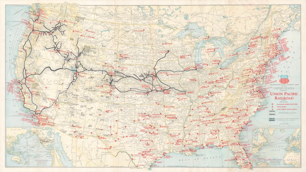
A 1942 World War II era Rand McNally map of the United States issued for the Union Pacific Railroad. It notes the locations of military facilities and highlights the contributions of the Union Pacific to the war effort.
The present edition is listed in the OCLC among the holdings of the University of California Santa Cruz, the University of Kansas, Missouri State University, and the University of Michigan.
A Closer Look
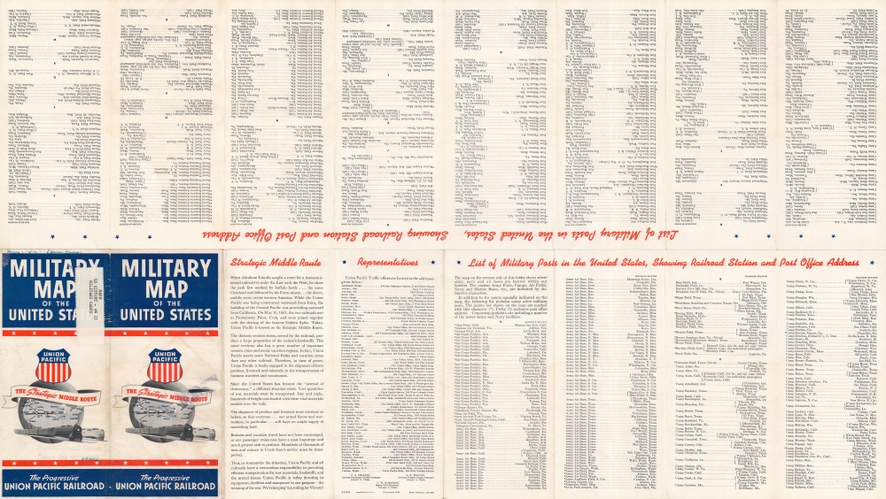
Black lines trace the Union Pacific network and associated lines, marked as either single or double track, while lighter gray lines represent the trackage of other companies. Military bases, airfields, forts, naval bases, and other facilities are indicated with red squares, airplanes, and anchors. Inset maps at the bottom-left and bottom-right illustrate connecting shipping lines across the Pacific and Atlantic Oceans. Rivers, mountains, cities, national parks, and state borders are also indicated. The verso includes an extensive list of military installations organized alphabetically, a list of Union Pacific offices around the country, and a section describing Union Pacific's contributions to the war effort.American Railroads and World War II
During World War I (1914 - 1918), American railroad lines were nationalized and placed under the management of the United States Railroad Administration. This system was unwound after the Great War, scarcely two years after its establishment. Still, in its brief existence, the U.S.R.A. oversaw important investments in rail infrastructure, standardization measures, and regulatory changes. However, the interwar period was difficult for the railroads, especially passenger rail, as competition from automobiles and aviation, along with the Great Depression, hurt ridership. Still, the continued oversight and standardization of the rail network (by the Interstate Commerce Commission) proved to be a boon during World War II (1939 - 1945), obviating the need for another wartime nationalization while allowing for the smooth interaction of various private railroads to support the war effort.Publication History and Census
This map was prepared by Rand McNally and Company and issued by the Union Pacific Railroad in 1942. The copyright names C. J. Collins, the company's General Passenger Traffic Manager, also credited in several other contemporanous maps and publications. Union Pacific had issued several editions of its 'Geographically Correct Map of the United States' prepared by Rand McNally in the 1920s and 1930s. The present example is a significantly modified wartime edition, touting the Union Pacific network as 'The Strategic Middle Route.'The present edition is listed in the OCLC among the holdings of the University of California Santa Cruz, the University of Kansas, Missouri State University, and the University of Michigan.
Cartographer
Rand, McNally and Co. (fl. 1856 - present) is an American publisher of maps, atlases and globes. The company was founded in 1856 when William H. Rand, a native of Quincy, Massachusetts, opened a print shop in Chicago. Rand hired the recent Irish immigrant Andrew McNally to assist in the shop giving him a wage of 9 USD per week. The duo landed several important contracts, including the Tribune's (later renamed the Chicago Tribune) printing operation. In 1872, Rand McNally produced its first map, a railroad guide, using a new cost effective printing technique known as wax process engraving. As Chicago developed as a railway hub, the Rand firm, now incorporated as Rand McNally, began producing a wide array of railroad maps and guides. Over time, the firm expanded into atlases, globes, educational material, and general literature. By embracing the wax engraving process, Rand McNally was able to dominate the map and atlas market, pushing more traditional American lithographic publishers like Colton, Johnson, and Mitchell out of business. Eventually Rand McNally opened an annex office in New York City headed by Caleb S. Hammond, whose name is today synonymous with maps and atlases, and who later started his own map company, C. S. Hammond & Co. Both firms remain in business. More by this mapmaker...
Condition
Very good. Some wear along fold lines and offsetting.
References
Rumsey 11259.003. OCLC 429905439.