This item has been sold, but you can get on the Waitlist to be notified if another example becomes available, or purchase a digital scan.
1948 Hudson Map Company City Plan or Map of Minneapolis, Minnesota
Minneapolis-hudson-1948$100.00


Title
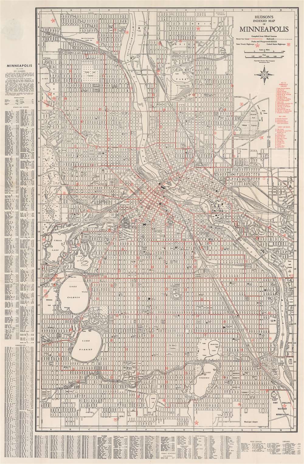
Hudson's Indexed Map of Minneapolis.
1948 (undated) 33.5 x 22 in (85.09 x 55.88 cm) 1 : 21120
1948 (undated) 33.5 x 22 in (85.09 x 55.88 cm) 1 : 21120
Description
This is a c. 1948 Hudson Map Company city plan or map of Minneapolis, Minnesota. The Mississippi River cuts through the center of town before turning to the right and flowing off the map just above the Fort Snelling Military Reservation and its U.S. Veterans Hospital. Several railway pass through the city, including the Great Northern Railway, the Chicago, Milwaukee, St. Paul, and Pacific, and the Northern Pacific. Overprinted red stars mark Minnesota state highways and red shields mark U.S. highways. Red overprinting also highlights Minneapolis streetcar and bus lines. An index along the left lists streets alphabetically and numerically. Below the map, similar indexes identify city parks, public schools, post offices, and libraries.
Publication History and Census
This map was created and published by the Hudson Map Company c. 1948. We have been unable to locate any other surviving examples of this map.Cartographer
The Hudson Map Company (1892 - present) was founded in Minneapolis in 1892 by Horace B. Hudson. Hudson began his business with a small handbook of Minneapolis that was soon recognized as essential to visitors as well as those who were just moving into the area. Initially located in downtown Minneapolis, the firm quickly began expanding and published maps and handbooks for citizens and businesses. In the early 1900s Charles L. Hall moved to Minneapolis and, having worked for a company that specialized in making promotional maps, soon began working for the Hudson Map Company. Hall and another employee, Walter Eng, bought the Hudson Map Company from Hudson a few years later. Hall and Eng changed direction slightly by opening a map store (which remained in business until 2011, when the Hudson Map Company decided that it was going to focus more on internet sales). Eng retired in 1945 and Hall became the sole owner of the business. Kenneth Hall, Charles Hall's son, joined the business in 1952 was president by 1965. In 1972, Charles T. Hall became a part of the family business, and in 1997 Joshua T. Hall, the fourth generation of the Hall family to work at the Hudson Map Company, joined the firm as a cartographer. The Hudson Map Company was sold in 2012 to its current owner. More by this mapmaker...
Condition
Very good. Exhibits light wear along original fold lines. Verso repairs to fold separations.