This item has been sold, but you can get on the Waitlist to be notified if another example becomes available, or purchase a digital scan.
1856 Ensign, Bridgeman, Fanning Map of Minnesota Territory
Minnesota-ensignbridgemanfanning-1856$925.00


Title
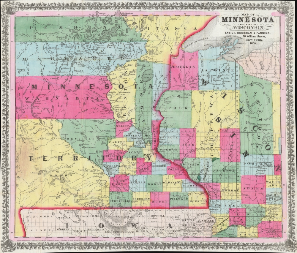
Map of Minnesota and Part of Wisconsin.
1856 (dated) 19 x 22 in (48.26 x 55.88 cm) 1 : 1210000
1856 (dated) 19 x 22 in (48.26 x 55.88 cm) 1 : 1210000
Description
A stunning 1856 Ensign, Bridgman, and Fanning map of Minnesota Territory representing the early settlement of Minnesota. This map illustrates the beginning of the settlement plan for Minnesota proposed by Jonathan Carver in his 1778 Travels. When this map was issued, life in Minnesota was characterized by harsh living conditions and frontier lawlessness dominated by American Indian relations and the fur trade.
This map focuses on just this kind of infrastructure, noting rapids, fords, ferries, trading posts, and more. Likewise, multiple First Nations settlements (Indian Village, Black Dog Village, Yankton Village, etc.) - representing for early settlers at once valuable allies, critical trading partners, and an existential threat. There are also several military forts and reserves noted - signals to potential settlers that the U.S. Government was fully invested the development of Minnesota.
A Closer Look
Coverage embraces all of modern-day Minnesota, as well as portion of what would become Dakota Territory. It also includes the western parts of Wisconsin and northern Iowa - the major access points. Lake Superior appears in the upper right. Strikingly bright coding defines counties - here mostly focused on the well-organized southeast portions of the territory. The remains portions of the territory are divided into much larger counties indicative of limited survey work and settlement.Minnesota Territory (1849 - 1858)
Minnesota Territory was incorporated on March 3, 1849, carved out of the 1803 Louisiana Purchase Territories and the 1818 British Cession. The original territory included all of today's Minnesota, as well as North and South Dakota. At the time, Minnesota Territory had three significant pioneer settlements: St. Paul, St. Anthony/Minneapolis, and Stillwater, plus two military reservations: Fort Snelling and Fort Ripley. As evident here, there were no interurban roads within the territory or connecting to adjoining territories - all transportation relied on the regions extensive network of lakes and rivers.This map focuses on just this kind of infrastructure, noting rapids, fords, ferries, trading posts, and more. Likewise, multiple First Nations settlements (Indian Village, Black Dog Village, Yankton Village, etc.) - representing for early settlers at once valuable allies, critical trading partners, and an existential threat. There are also several military forts and reserves noted - signals to potential settlers that the U.S. Government was fully invested the development of Minnesota.
Publication History and Census
This map was issued in New York in 1856 by Ensign, Bridgman, and Fanning. The present example is the second edition - the first appeared in 1855. This map appears to be a continuation on the same scale as the Ensign, Bridgman, and Fanning Map of Iowa, 1855 (See Rumsey 4414) suggesting that they were mutual extracts from a larger map or possibly even from the same plate. Scarce. We note just 3 known examples: David Rumsey Collection (Stanford), Hennepin County Library, Wisconsin Historical, and Minnesota Historical.CartographerS
Edward Hooker Ensign (August 18, 1818 - July 10, 1871) was an American map and print publisher based in New York during the middle part of the 19th century. Edward was born in West Hartland, Connecticut. Little is known of Ensign's training but he may have inherited his business from his father, Timothy Ensign (1795 - 1859), who was a map publisher active in New York. Ensign seems to have had a flair for partnerships and variously published with Humphrey Phelps (1799 - 1875), Horace Thayer, Thomas C. Fanning (1805 - 1873) and Erastus C. Bridgman (1817 - 1870), among others. His various imprints include 'Phelps and Ensign' (1841-1844), 'T. and E. H. Ensign' (1844-1848), 'Ensign and Thayer' (1849), 'Ensign, Thayer, and Company' (1850-1851), 'Horace Thayer and Company' (1852), and 'Ensign, Bridgman and Fanning' (1854-1863). It appears that father and son worked together for some time as well, publishing as either 'T. and E. H. Ensign' or 'Ensigns'. At least some of these companies maintained offices in both Buffalo and New York City. More by this mapmaker...
Erastus Clark Bridgman (October 31, 1817 - August 25, 1870) was a New York City based map publisher active in the middle of the 19th century. Bridgman was born in Westhampton, Massachusetts. He was in South Carolina in 1849, where his first child was born, but moved to New York City by 1850. Bridgman was in partnership with Edward H. Ensign (1818 - 1871) and Horace Thayer from 1850 - 1852, publishing under the imprint of 'Ensign, Thayer, and Co.' Later, from 1854 - 1863, the partnership changed to Edward H. Ensign, Thomas C. Fanning (1805 - 1873), and Bridgman, publishing as 'Ensign, Bridgman and Fanning.' After his death, the Bridgman firm was taken over by his son Edward Clark Bridgman (1849 - 19??). Learn More...
Thomas Colt Fanning (August 2, 1805 - November 21, 1873) was a New York based map publisher active in the middle part of the 19th century. Fanning was born in Norwich, Connecticut. As a young man he apprenticed at a drugstore in Rochester, New York. When he reached his maturity, he relocated to Albion, New York, where he opened the town's first drugstore. He sold this business in 1849 to move to Brooklyn and enter the map publishing business. He initially partnered with Humphrey Phelps (1799 - 1875) and Thomas C. Fanning (1805 - 1873), joining the firm of 'Phelps and Fanning' as a junior partner. From 1854 to 1863 he partnered with Edward H. Ensign (1818 - 1871) and Erastus Clark Bridgman (1817 - 1870), publishing as 'Ensign, Bridgman and Fanning.' Learn More...
Condition
Very good. Accompanies original binder.
References
Hennepin County Library Special Collections Repository, MAP0890. Wisconsin Historical Society GX902 1855 E. Karrow, R. W., Checklist of Printed Maps of the Middle West to 1900, #7-0693. OCLC 953569516. Rumsey 4583.002.