This item has been sold, but you can get on the Waitlist to be notified if another example becomes available, or purchase a digital scan.
1861 Mitchell Map of Minnesota and the Dakotas
MinnesotaDacotah-mitchell-1861$87.50

Title
Minnesota and Dacotah.
1860 (dated) 11.25 x 13.75 in (28.575 x 34.925 cm) 1 : 3400000
1860 (dated) 11.25 x 13.75 in (28.575 x 34.925 cm) 1 : 3400000
Description
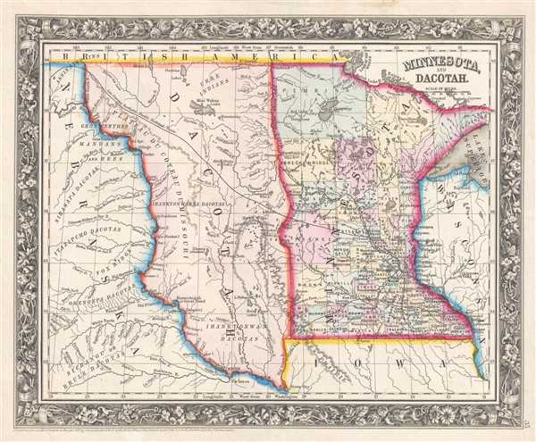
This is an 1861 Samuel Augustus Mitchell, Jr. map of Minnesota and part of Wisconsin, Iowa, and the Nebraska Territory, as well as the Pembina Region, the portion of the Minnesota Territory between the Missouri River and the Red River that remained unorganized after Minnesota joined the Union in 1858. The map depicts the region from the Nebraska Territory to Wisconsin and from Canada (British America) to Iowa and the Nebraska Territory.
The Unincorporated Territory of 'Dacotah'
During the nearly three year period between Minnesota's statehood on May 11, 1858 and the creation of the Dakota Territory in March 2, 1861, the portion of what had been the Minnesota Territory that fell between the Missouri River and Red River, Minnesota's newly-created western border, remained unattached to any official territory of the United States. Immediately following Minnesota's statehood, a provisional government was set up in the Pembina Region which lobbied for recognition as a territory. In doing so, a formally recognized local government would be in place, which is an important part of encouraging settlement in a region. Even so, the proposal was mostly ignored by the Federal government until the Dakota Territory was formed, which upon its creation included most of present day Montana, Wyoming, and both North and South Dakota.The Governor Stevens Route of the Transcontinental Railroad
Another important detail of this map is the inclusion of a portion of the Governor Stevens Route, which was one of the proposed routes for the transcontinental railroad. A veteran of the U.S. Corps of Engineers and the U.S. Coast Survey, Stevens was keenly aware of the pressing need for a transcontinental railroad to unite the rapidly expanding nation. As he traveled westward toward Olympia, Washington, the seat of the territorial government, Stevens surveyed what he believed was the best and most practical route for the Pacific Railroad. Starting from St. Paul, Minnesota, Stevens surveyed and proposed a route that roughly following the 47th and 49th parallels westward and terminated at Puget Sound. He boasted that the harsh winter conditions of the northern territories would 'not present the slightest impediment to the passage of railroad trains'. To this the expedition's naturalist George Stuckley responded, 'A road might be built over the tops of the Himalayan mountains – but no reasonable man would undertake it'. Though the Stevens route appears on many early maps, it was not seriously entertained by any rational party other than Stevens himself. Following Stevens' death in 1862 during the Civil War Battle of Chantilly, the campaign for a far northern route lost its only champion and consequently its momentum. Nonetheless, the northern Pacific route was eventually completed, and Ulysses S. Grant drove the 'Golden Spike' in western Montana on September 8, 1883.A Closer Look
Highly detailed, particularly for a map of a state that was only a few years old when it was created, individual counties in Minnesota are illustrated, labeled, and color coded for easy differentiation. County seats are labeled as well, along with numerous rivers and lakes. In the Pembina Region (Dacotah), the ranges of Native American tribes are labeled, and the ephemeral nature of these ranges are hinted at due to the fact that there are no defined borders. Rivers, lakes, and creeks within the region are also labeled. The Nebraska Territory is illustrated in much the same manner, with the ranges of Native American tribes, rivers, and creeks labeled throughout. The whole is surrounded by the attractive floral border common to Mitchell atlases between 1860 and 1865.Publication History
This map was prepared by S. A. Mitchell Jr. for inclusion in the 1861 edition of Mitchell's New General Atlas. Like many American map publishers of this period, Mitchell did not regularly update his copyrights, consequently this map is dated and copyrighted to 1860: 'Entered according to Act of Congress in the Year 1860 by S. Augustus Mitchell Jr. in the Clerk's Office of the District Court of the U.S. for the Eastern District of Pennsylvania'.Cartographer
Samuel Augustus Mitchell (March 20, 1792 - December 20, 1868) began his map publishing career in the early 1830s. Mitchell was born in Bristol, Connecticut. He relocated to Philadelphia in 1821. Having worked as a school teacher and a geographical writer, Mitchell was frustrated with the low quality and inaccuracy of school texts of the period. His first maps were an attempt to rectify this problem. In the next 20 years Mitchell would become the most prominent American map publisher of the mid-19th century. Mitchell worked with prominent engravers J. H. Young, H. S. Tanner, and H. N. Burroughs before attaining the full copyright on his maps in 1847. In 1849 Mitchell either partnered with or sold his plates to Thomas, Cowperthwait and Company who continued to publish the Mitchell's Universal Atlas. By about 1856 most of the Mitchell plates and copyrights were acquired by Charles Desilver who continued to publish the maps, many with modified borders and color schemes, until Mitchell's son, Samuel Augustus Mitchell Junior, entered the picture. In 1859, S.A. Mitchell Jr. purchased most of the plates back from Desilver and introduced his own floral motif border. From 1860 on, he published his own editions of the New General Atlas. The younger Mitchell became as prominent as his father, publishing maps and atlases until 1887, when most of the copyrights were again sold and the Mitchell firm closed its doors for the final time. More by this mapmaker...
Source
Mitchell, S. A., Mitchell's New General Atlas Containing Maps of the Various Countries of the World, Plans of Cities, Etc., embraced in Forty-Seven Quarto Maps, Forming a series of Seventy-Six Maps and Plans, together with Valuable Statistical Tables (Philadelphia: S. Augustus Mitchell, Jr.) 1861.
Mitchell's New General Atlas was published by Samuel Augustus Mitchell, Jr., the son of the prolific cartographer Samuel Augustus Mitchell. Many of the plates are derived from the his father's Mitchell's Universal Atlas, but not directly. The Mitchell's Universal Atlas was initially sold to Thomas, Cowperthwait, and Company in 1849, and again to Charles Deliver in 1856. It was Deliver who introduced the new vibrant color scheme, abandoning the older Mitchell's Universal Atlas green borders and themes for bright reds, blues, and yellows. Samuel Augustus Mitchell, Jr. acquired the Deliver plates in 1859. He added his own floral motif border, but doubled down on the vibrant color scheme, thus introducing to the American public the most vividly colored American atlas of the 19th century. In 1860, he published the first edition of his New General Atlas and, despite a slump in sales during the American Civil War, attained a level of success to rival his father. Mitchell would continue to publish the New General Atlas until 1887, when the firm formally closed.
Condition
Very good. Even overall toning. Blank on verso.
References
Rumsey 0565.025 (1860 edition).