This item has been sold, but you can get on the Waitlist to be notified if another example becomes available, or purchase a digital scan.
1827 Finley Map of Mississippi
Mississippi-finley-1827$150.00

Title
Mississippi.
1827 (undated) 11.5 x 9 in (29.21 x 22.86 cm)
1827 (undated) 11.5 x 9 in (29.21 x 22.86 cm)
Description
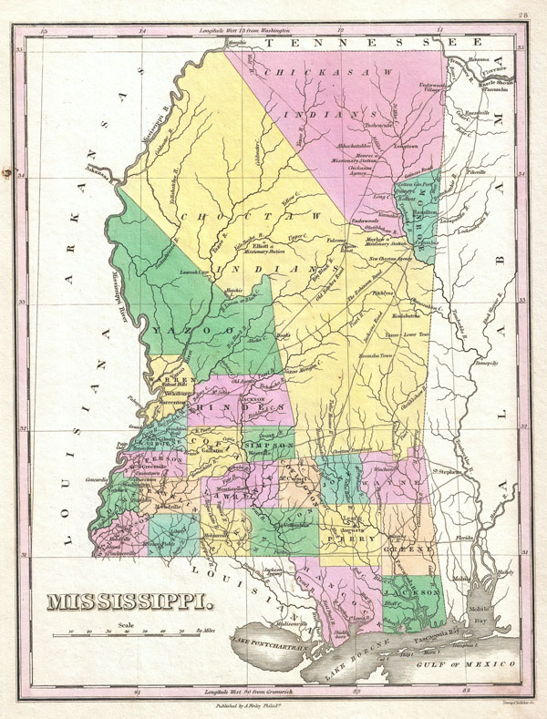
A beautiful example of Finley's important 1827 map of Mississippi. Depicts the state with moderate detail in Finley's classic minimalist style. Shows river ways, roads, canals, and some topographical features. Offers color coding at the county level. Title and scale in lower left quadrant.
Finley's map of Mississippi is particularly interesting and important due to its portrayal of the rapidly changing American Indian situation in the northern part of the state. In 1827 most of northern Mississippi was a confined territory assigned to the Chickasaw and Choctaw Indian Nations. Within the Indian lands numerous missionary stations are noted, including Elliot, Monroe, and Mayhew. Also notes the New Choctaw Agency. Just four years after this map was made the Chickasaw and Choctaw would forcibly relocated westward in the infamous 'Trail of Tears.' This map was updated yearly from 1824 to the mid 1830s. A full series of these maps is a powerful illustration of both the American Indian relocations.
Also of interest are the several roadways that run northwest through the Chickasaw and Choctaw territories. These are the Old Natchez Road (also called the Natchez Trace), the Robinson Road, and Jacksons Road. The roadways through the Indian territories were mostly traveled by missionaries and a hardy group known as 'Kaintucks.' Kaintucks were river men who made a living transporting goods down the Mississippi from Ohio and Indiana. Afterwards they would travel north by land from Jackson to Nashville, where they could once again navigate the rivers back to Ohio. In the early 19th century over 10,000 Kaintucks a year used these roads. The Robinson Road was also the primary postal route.
Engraved by Young and Delleker for the 1827 edition of Anthony Finley's General Atlas.
Cartographer
Anthony Finley (August 25, 1784 - June 9, 1836) was an American book and map publisher based in Philadelphia, Pennsylvania. Finley was born in Philadelphia in 1784. He opened a bookshop and publishing house at the Northeast corner of Fourth and Chestnut Street, Philadelphia in 1809. His earliest known catalog, listing botanical, medical and other scientific works, appeared in 1811. His first maps, engraved for Daniel Edward Clarke’s Travels in Various Countries of Europe, Asia, and Africa also appear in 1811. His first atlas, the Atlas Classica, was published in 1818. He soon thereafter published the more significant A New American Atlas and the New General Atlas…, both going through several editions from 1824 to 1834. Although most of Finley's cartographic material was borrowed from European sources, his atlases were much admired and favorably reviewed. In addition to his work as a printer, Finley ran unsuccessfully on the 1818 Democratic ticket for Philadelphia Common Council. He was a founding officer of the Philadelphia Apprentices’ Library, and a member of both the American Sunday-School Union and the Franklin Institute. He was also an ardent supporter of the American Colonization Society, an organization dedication to returning free people of color to Africa - which led to the founding of Liberia. Much of his wealth was dedicated to supporting this cause. Finley was active as a publisher until his 1836 death, apparently of a 'lingering illness.' Shortly thereafter advertisements began appearing for his map business and plates, most of which were acquired by Samuel Augustus Mitchell. More by this mapmaker...
Source
Finley, Anthony, A New General Atlas, Comprising a Complete Set of Maps, representing the Grand Divisions of the Globe, Together with the several Empires, Kingdoms and States in the World; Compiled from the Best Authorities, and corrected by the Most Recent Discoveries, Philadelphia, 1827.
Condition
Very good condition. Original pressmark. Blank on verso.
References
Rumsey 0285.023 (1831 edition). Phillips (Atlases) 4314, 760, 752, 6045.