
1936 Gulfport Printing Map of the Mississippi Gulf Coast

This item has been sold.
The Mississippi Gulf Coast. / Angler's Map and Visitor's Guide of the Mississippi Gulf Coast.
Riviera of the American South.
Choose a Collection:
- Digital Map Information
- Suitable for large format printing
- Full resolution TIFF file
- ICC color profile embedded
- Delivered instantly via download link
This Item
Enquire
Riviera of the American South.
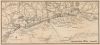
This is an unrecorded 1936 map of the Mississippi Gulf Coast prepared by the Gulfport Printing Company. It is notable for including detailed information on both maritime and terrestrial features, reflecting the close integration of land and sea in the region.A Closer Look
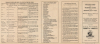
The map covers the Mississippi Gulf Coast from the vicinity of Claremont Harbor near the Louisiana-Mississippi border in the west to Graveline Bayou in the east. On land, roads and railroads (particularly the Louisville and Nashville) are clearly traced with black lines. Rivers, creeks, and other waterways are also traced. Cities and towns are labeled, with shading and illustrations used to denote developed areas, parks, golf courses, cemeteries, a historical marker for the founding of Biloxi, and more. Many features - from hotels to train stations, schools, and canneries - are recorded with labels stretching out into the Gulf of Mexico. Horizontal shading is used to indicate bayous. On water, shoals, islands, lights, beacons, soundings, passes, and an important shipping channel to Gulfport are recorded. An inset key map at the top-left displays the wider region from New Orleans to Graveline Bay and Bayou. The verso contains extensive suggestions on fishing in the area, including the types of fish present, the best seasons to catch them, where to catch them, and the best bait and tackle to use.Riviera of the American South
This map was produced at a time when the Mississippi Gulf Coast had become established as a premier destination for travel and leisure. The completion of the Old Spanish Trail (Highway 90) and the construction of majestic hotels like the Edgewater Gulf brought an influx of wealthy tourists. Additionally, the fishing and seafood industries boomed, particularly in Biloxi, which earned the title of 'Seafood Capital of the World.' Massive canning factories lined the shore, processing an incredible volume of shrimp and oysters harvested by a diverse workforce of European immigrants and locals, making the coast a global leader in seafood production. Following the dredging of a shipping channel at the start of the century, Gulfport had emerged as one of the major commercial ports of the South.Even as the 1930s ushered in the Great Depression and the Mississippi Gulf Coast faced economic hardship, a lifeline was found through federal intervention and an industrial pivot. The Works Progress Administration (WPA) funded the expansion of Gulfport's deep-water harbor, which solidified the region's status as a critical shipping hub for lumber and cotton, while seawall projects along the coast protected rail and road infrastructure and provided badly-needed jobs. Despite the lean years, tourism endured in a more accessible form, as the coast became a haven for those seeking affordable recreation, becoming known as the 'Poor Man's Riviera' and later as the 'Redneck Riviera.'
Publication History and Census
This map was prepared by the Gulfport Printing Company in 1936 for the Gulfport Chamber of Commerce. We have been unable to locate any other examples in institutional collections or on the market. Although not cataloged, several editions of the Library of Congress' Catalog of Copyright Entries indicate that later editions of this 'Angler's Map and Visitor's Guide' were printed and published by Gulfport Printing in 1946 and 1961.Cartographer
Gulfport Printing Company (fl. c. 1918 - 1969) was a Gulfport, Mississippi based printer, producing a range of works from postcards and maps to religious books and works on local history. It is unclear what relation, if any, existed with a contemporaneous company of the same name based in Texas, primarily Houston, that was active in the 1920s. Further Details...
Condition
Very good. Slight wear on original folds. Slight transferrence. Even overall toning.