This item has been sold, but you can get on the Waitlist to be notified if another example becomes available.
1967 Aiena Pictorial Map of the Plantations on the Mississippi River
MississippiRiverPlantations-aiena-1967$600.00

Title
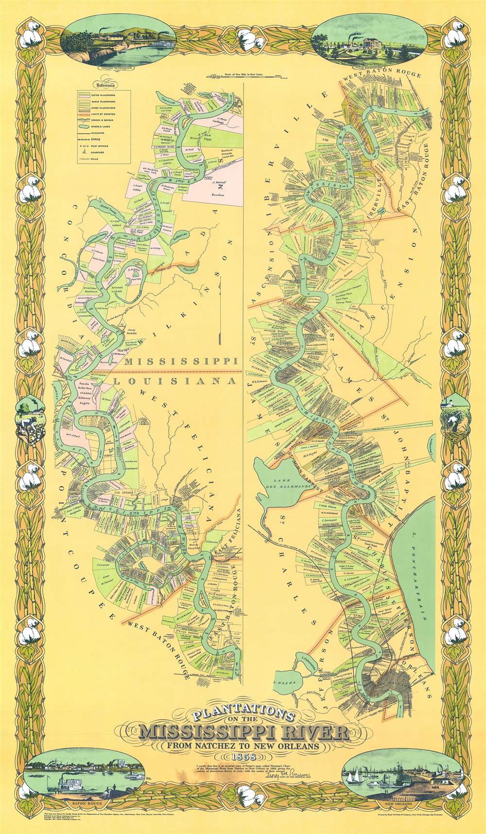
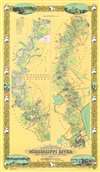
Plantations on the Mississippi River From Natchez to New Orleans 1858.
1967 (dated) 52.5 x 30.5 in (133.35 x 77.47 cm) 1 : 126720
1967 (dated) 52.5 x 30.5 in (133.35 x 77.47 cm) 1 : 126720
Description
This is an attractive 1967, special edition, Joseph Anthony Aiena re-envisioning of the famous 'Persac Map' or 'Norman Map', illustrating the plantations on the Mississippi River from New Orleans to Natchez. The map is divided into two sections. The left section covers from Natchez to Baton Rouge, and the right section from Baton Rouge to New Orleans. Along the way, plantation estates are illustrated and color-coded with the owners duly named. The properties are universally long and thin, assuring all-important river access to all. The map is surrounded by a decorative cotton-themed border.
The Norman / Persac Map
Originally published in 1858, the Norman / Persac Map was drawn by the French landscape painter and real-estate artist Marie Adrien Persac (1823 - 1873). Persac issued the map in partnership with the Benjamin Moore Norman (1809 - 1860). The map is an outgrowth of Persac's travels up and down the Mississippi surveying and completing landscapes of Plantation estates for New Orleans auction houses. The map was originally intended to be one of three, covering plantations on the Mississippi valley as far north as Memphis. One the first map was published. Today the original Norman / Persac Map survives in fewer than 10 examples, 5 five which are in institutional collections. A surviving example sold at Neal Auctions in New Orleans several years ago for an astounded 316,000 USD.Publication History and Census
This map is based upon the 1858 Norman / Persac Map, but has been entirely redrawn by Joseph Anthony Aiena, then working for the Art Department of the Chambers Agency (New Orleans). It was first published in 1931 by Pelican Book Shop and reissued, as here in 1967, by Pelican Publishing Company. Printed by the Rand McNally Company. Examples appear on the market from time to time and remain consistently desirable.CartographerS
Joseph Anthony Aiena (December 222, 1877 - September 25, 1951) was an American illustrator and artist active in New Orleans, Louisiana in the first half of the 20th century. Aiena was born in New Orleans and spent most of his life in that city. Until 1920 he worked from the New Orleans Engraving and Electrotype Company. Afterwards he was an independent commercial illustrator. In cartographic circles, he is best known for retooling the famous Marie Adrien Persac (1823 - 1873) / Benjamin Moore Norman (1809 - 1860) map illustrating plantations along the Mississippi River. He also designed the label for Jax Brewery and was a successful landscape painter. Aiena registered for the draft in both World War I and World War II. During the WWI, he was dismissed because of an 'eye twitch', and during WWII, because he was too old (65). More by this mapmaker...
Marie Adrien Persac (December 14, 1823 - July 21, 1873) was a French painter, cartographer, photographer, and educator active in Louisiana in the middle part of the 19th century. Persac was born in Saumur, France - supposedly to a well-to-do family. He lived for a type in Lyon, France, before relocating to the United States in 1842, 'with 100,000 francs and a yen to hunt buffalo'. In 1851 he married Marie Odile Daigre (1823 - 1873), the daughter of a Baton Rouge farmer. He 1856, he partnered with William G. Vail, to open a daguerreotype photography studio on Florida Street in Baton Rouge - then an innovative new field. Poor financial management led this business to collapse after a short time in operation. He then took work as an artist and lithographer with 'Pessou and Simon' of Baton Rouge. (Of note, Louis Lucien Pessou, the senior partner, was a free man of color, born in New Orleans in 1824. He was the first African-American from New Orleans to play a major role in the city's printmaking.) At the same time he supplemented his income by painting plantations and surveying the property lines for the local auction and realty market. It was no doubt this work that let him to Benjamin Moore Norman, with whom he partnered to issue an important map illustrating the plantation properties along the Mississippi River from New Orleans to Natchez. As an artist he became well known for painting Louisiana plantation houses and antebellum life on the Mississippi. From 1859 to 1869, he completed 21 drawings of estates in collaboration with civil engineer Eugene Surgi (1826 - 1914). During the American Civil War (1861 - 1865) he remained in Louisiana, but did not participate in the War. Ain 1865, at the close of the war, he set up a photography studio in New Orleans. By 1867, his listed his profession in the New Orleans city directory was 'architect' and in 1873 'engineer'. He died on July 21, 1873 in Manchac, Louisiana at the Daigre family house and he is buried at Saint Joseph Catholic Cemetery in Baton Rouge. Learn More...
Benjamin Moore Norman (December 22, 1809 - February 1, 1860) was an American bookseller, publisher, and writer active in the first part of the 19th century. Norman was born in Hudson, New York, where his father William E. Norman was a local bookseller. He had a brief clerkship in New York City that he left when his father died, at which time he returned to Hudson to take over the book business. Shortly thereafter he relocated to Philadelphia and, in 1837, to New Orleans. A few years later, Norman took inspiration from the seminal archeological work of John Lloyd Stephens (1805 - 1852), who pioneered research on ancient Mayan civilization in the Yucatán. On his own reconnaissance, Norman booked traveled to the Yucatán Peninsula, where he visited and documented Valladolid, Chichén Itzá, Uxmal, and San Francisco de Campeche, among other sites. The scholarly merit of Norman's resultant works, Rambles in Yucatán (1842) and Views of Ancient Monuments in Central America, Chiapas, and Yucatan (1844) have been harshly criticized, both then and today. The work was nonetheless popular with the public, establishing Norman's financial security. By 1845 he established a bookbinding ,publishing, and printing establishment at 18 Camp Street, New Orleans. There, in 1845, he published Norman's Plan of New Orleans and Environs, an excellent map of New Orleans drawn by the Prussian surveyor Carl August Henry Möllhausen (1814 - 1882). This map was republished in 1854. In 1858, Norman partnered with the French surveyor and painter Marie Adrien Persac (1823 - 1873) to issue a phenomenal large scale real-estate map depicting the plantations of the Mississippi. The grand work, today practically unobtainable, was supposed to be one of three such maps, covering Mississippi Plantations as far north as Memphis. Norman died of pneumonia in Mississippi in 1860, just before the outbreak of the American Civil War (1861 - 1865). Learn More...
Rand, McNally and Co. (fl. 1856 - present) is an American publisher of maps, atlases and globes. The company was founded in 1856 when William H. Rand, a native of Quincy, Massachusetts, opened a print shop in Chicago. Rand hired the recent Irish immigrant Andrew McNally to assist in the shop giving him a wage of 9 USD per week. The duo landed several important contracts, including the Tribune's (later renamed the Chicago Tribune) printing operation. In 1872, Rand McNally produced its first map, a railroad guide, using a new cost effective printing technique known as wax process engraving. As Chicago developed as a railway hub, the Rand firm, now incorporated as Rand McNally, began producing a wide array of railroad maps and guides. Over time, the firm expanded into atlases, globes, educational material, and general literature. By embracing the wax engraving process, Rand McNally was able to dominate the map and atlas market, pushing more traditional American lithographic publishers like Colton, Johnson, and Mitchell out of business. Eventually Rand McNally opened an annex office in New York City headed by Caleb S. Hammond, whose name is today synonymous with maps and atlases, and who later started his own map company, C. S. Hammond & Co. Both firms remain in business. Learn More...
Condition
Very good. Minor discolorations at the bottom center. Else very clean.
References
OCLC 865954033.