1884 Glazier Map 'Rediscovering' the Source of the Mississippi, Minnesota
MississippiSource-glazier-1884$4,250.00


Title
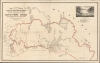
Map Illustrative of Captain Willard Glazier's Voyage of Exploration to the Source of the Mississippi River Drawn from Delineations by his Indian Guide Che-No-Wa-Ge-Sic.
1884 (undated) 21.5 x 33.75 in (54.61 x 85.725 cm) 1 : 253440
1884 (undated) 21.5 x 33.75 in (54.61 x 85.725 cm) 1 : 253440
Description
This is an impressive c. 1887 Willard Glazier map of northern central Minnesota in the vicinity of Leech Lake and Lake Itasca. The map records Willard W. Glazier's claims to have discovered the 'true' source of the Mississippi River at Elk Lake, which he attempts to rename 'Lake Glazier'. Glazier's claims contain an element of truth, and this map has merit, despite his 'discoveries' being universally derided by the geographical establishment due largely to distaste for his bombastic and abrasive personal character.
Glazier's voyage, with his brother George and friend Barrett Channing Paine, began in Brainerd, Minnesota. They intended to follow the Mississippi from 'Source to Sea'. The trio followed the government road to Leech Lake, from which, on July 17, 1881, they set off in a canoe, following various lakes, streams, and the De Soto River westward to Lake Itasca, where they set up camp on an island on July 21. From there, the group traveled south, where, after some exploration, Glazier determined that Elk Lake (Glazier) was the Mississippi's source. His return took him on a wide arc north of Lake Itasca along the Mississippi to Lake Bemidji, Cass Lake, and Winnibegoshish. There, on July 28-29, the team rested at a Chippewa Village before navigating down the Mississippi to the Gulf of Mexico, which they reached on November 15, 1881.
To support his claims, and perhaps intentionally mirroring Schoolcraft's Ojibwe guide O-zaw-wan-dib (fl. 1797 - 1832), Glazier invokes his own 'Indian Guide' Che-No-Wa-Ge-Sic, of whom he writes,
But was he? Certainly, Glazier was pretentious and bombastic, but in essence, he was right. Elk Lake is the largest of Lake Itasca's feeder lakes and is closer to the 'source' of the Mississippi than Itasca. James H. Baker ultimately concludes that Lake Itasca 'is the first great gathering place and reservoir of the headwaters', but not necessarily the 'source'. A close look at the criticism directed towards Glazier suggests more of a personal and professional distaste than a concrete criticism of his 'discoveries'. Glazier's shameless self-promotion, lazy explorer's ethic, and lack of scientific credentials earned him more enemies than any falsity in his claims. In essence, in the opinion of the establishment, Glazier didn't work hard enough or have the credentials to make a great discovery. In Baker's influential words, earlier explorers like Schoolcraft and Nicolette 'toiled weeks and months with all the privations incident to an untrodden wilderness', while Glazier's team reached the source in days … 'doubtless in a sleeping car.'
A Closer Look
Coverage is loosely centered on Cass Lake but embraces Leech Lake, Lake Winnibigoshish, Lake Bemidji, and Lake Itasca - thus tracing Glazier's exploratory route in red. Although Henry Schoolcraft (1793 - 1864) identified Lake Itasca as the river's primary source in 1832, there remained general consideration that there may be a further source. Joseph Nicolette, for example, traveling with John Fremont in the 1830s, further identified nearby Nicolette Creek as the 'start' of the great river. Glazier is here attempting something similar. Elk / Glazier Lake is situated just south of Lake Itasca. It is one of Lake Itasca's many feeder lakes, but geologists have long since determined that neither Elk Lake nor any of the other minor feeder lakes are large enough to constitute a 'source' for the Mississippi. An enchanting illustration of the lake as a woodland paradise appears in the upper right.Glazier's voyage, with his brother George and friend Barrett Channing Paine, began in Brainerd, Minnesota. They intended to follow the Mississippi from 'Source to Sea'. The trio followed the government road to Leech Lake, from which, on July 17, 1881, they set off in a canoe, following various lakes, streams, and the De Soto River westward to Lake Itasca, where they set up camp on an island on July 21. From there, the group traveled south, where, after some exploration, Glazier determined that Elk Lake (Glazier) was the Mississippi's source. His return took him on a wide arc north of Lake Itasca along the Mississippi to Lake Bemidji, Cass Lake, and Winnibegoshish. There, on July 28-29, the team rested at a Chippewa Village before navigating down the Mississippi to the Gulf of Mexico, which they reached on November 15, 1881.
To support his claims, and perhaps intentionally mirroring Schoolcraft's Ojibwe guide O-zaw-wan-dib (fl. 1797 - 1832), Glazier invokes his own 'Indian Guide' Che-No-Wa-Ge-Sic, of whom he writes,
… a council was held, and my object stated to them. They were requested to delineate maps of the country, and to furnish an interpreter, guides and canoes. Che-no-wa-ge-sic said: 'My brother, the country you are going to visit is my hunting ground. I have hunted there many years, and planted corn on the shores of Lake Itasca. My father, now an old man, remembers the first white chief who came to look for the source of the Great River. But, my brother, no white man has yet seen the head of the Father of Waters. I will myself furnish the maps you have called for, and will guide you onward.Glazier promoted his discovery through two books, Down the Great River; Embracing an Account of the Discovery of the True Source of the Mississippi (1887) and Headwaters of the Mississippi comprising biographical sketches of early and recent explorers of the great river, and a full account of the discovery and location of its true source in a lake beyond Itasca (1894). Glazier's claims were nonetheless universally derided and rejected by the geographical establishment, who, led by statesman James Heaton Baker (1829 - 1913), pronounced him stupid, pretentious, shameful, bombastic, a fraud, a liar, a plagiarist, a 'tourist', a 'literary thief', a 'falsifier of history', a 'quack explorer', a 'charlatan adventurer', and 'a merry fellow on a jolly outing'.
But was he? Certainly, Glazier was pretentious and bombastic, but in essence, he was right. Elk Lake is the largest of Lake Itasca's feeder lakes and is closer to the 'source' of the Mississippi than Itasca. James H. Baker ultimately concludes that Lake Itasca 'is the first great gathering place and reservoir of the headwaters', but not necessarily the 'source'. A close look at the criticism directed towards Glazier suggests more of a personal and professional distaste than a concrete criticism of his 'discoveries'. Glazier's shameless self-promotion, lazy explorer's ethic, and lack of scientific credentials earned him more enemies than any falsity in his claims. In essence, in the opinion of the establishment, Glazier didn't work hard enough or have the credentials to make a great discovery. In Baker's influential words, earlier explorers like Schoolcraft and Nicolette 'toiled weeks and months with all the privations incident to an untrodden wilderness', while Glazier's team reached the source in days … 'doubtless in a sleeping car.'
Publication History and Census
This map was prepared by Willard Worchester Glazier and engraved by Rand McNally. The date of publication is unclear, but it must have been separately issued around 1884, predating the 1887 publication of Glazier's account. The map is referenced in a letter sent by Glazier to Charles Patrick Daly (1816 - 1899), President of the American Geographical Society, promoting his discovery. (ALS from Glazier to Daly, June 16, 1884, University of Wisconsin-Milwaukee). The map is rare, but we note holdings at the Buffalo and Erie County Public Library, Harvard University, Minnesota Historical Society, University of California-Berkeley, Wisconsin Historical Society, and Yale University.CartographerS
Willard Worchester Glazier (August 22, 1841 - April 26, 1905) was an American army officer, adventurer, lecturer, self-promoter, and conman active in the second half of the 19th century. Glazier was born in Fowler, New York. He attended Gouverneur Wesleyan Seminary and worked as a trapper in his spare time, saving enough to attend the State Normal School in Albany. During the American Civil War (1861 - 1865), Glazier served the Union cause in the Harris Light Cavalry, 2nd New York Cavalry. He was captured in 1863 and held in the notoriously harsh Libby Prison before escaping with about 100 others in 1864, only to be immediately recaptured and sent to the even more notorious Andersonville Prison. He escaped Andersonville in 1865 and returned to Albany to join the 26th New York Cavalry as a First Lieutenant. Glazier wasted no time in capitalizing on his wartime adventures in two self-authored books: Capture, Prison-Pen and Escape (1865) and Three Years in the Federal Cavalry (1870). These books were immensely successful, the first selling nearly 400,000 copies. He leveraged their success to launch a lecturing career in the Midwest. Despite his accomplishments, Glazier was reviled by most who knew him. He developed a practice of traveling with comely young women, who loudly promoted his lectures using their considerable charms. In one of many instances of public outrage, in 1879, an angry mother accused him of impregnating and abandoning her 15-year-old daughter. (The young woman herself refused to press charges.) Many of his lectures were promoted as fundraisers for the Grand Army of the Republic Relief Fund and other local charities, but none record receiving donations. He also claimed to be friends with George Armstrong Custer (1839 - 1876). The connection is dubious, but Custer, having died, could hardly refute them. The lectures themselves were poorly reviewed, the enticement of Glazier's young women being more of a draw than the man himself. The editor of the Iowa City Daily Press wrote,
Now Captain Glazier may be a good lecturer, and it may be that some deadbeat is travelling under his name … yet all who heard him are under the impression that he is a monumental fraud, only one degree less of an idiot than Sergeant Bates [another touring lecturer] … and relies on the efforts of the two ladies who preceded him, and bore the general public with pitiful wails to buy tickets. (October 9, 1876)He also staged self-promotional stunts. In one instance, he suddenly went missing and claimed to have been captured by Indians with three others who were burnt alive (so he claimed) while he made a heroic escape, outrunning his pursuers. Glazier's miraculous reappearance was reported by the Cleveland Leader under the heading Pained to Announce. His biggest scam was an 1881 expedition to clear doubt regarding Henry Schoolcrafts's 1832 identification of Lake Itasca as the source of the Mississippi River. When the planned expedition was announced, the St. Paul Daily Globe entreated American Indians in the region,
We have only to say to the untutored savages of the West, whose crimes are manifold … that you have now an opportunity to redeem yourselves. Prepare your shot-guns, and wait the coming of a careworn literary man in a canoe … Men of the Mississippi, do your duty. (June 26, 1881)Following the voyage, he contracted Rand McNally to publish a large map illustrating his discovery of Elk Lake (long known), which he identified as the source of the Mississippi, then renamed and significantly enlarged as 'Lake Glazier.' The geographic establishment aggressively rebuked Glazier's claims. Despite being technically correct, investigating Glazier, the Minnesota Historical Society dubbed him a 'quack explorer and charlatan adventurer.' Glazier was nonetheless undaunted, promoting his claims with two books, Down the Great River; Embracing an Account of the Discovery of the True Source of the Mississippi (1887) and Headwaters of the Mississippi comprising biographical sketches of early and recent explorers of the great river, and a full account of the discovery and location of its true source in a lake beyond Itasca (1894). He died of heart disease in Albany. More by this mapmaker...
Rand, McNally and Co. (fl. 1856 - present) is an American publisher of maps, atlases and globes. The company was founded in 1856 when William H. Rand, a native of Quincy, Massachusetts, opened a print shop in Chicago. Rand hired the recent Irish immigrant Andrew McNally to assist in the shop giving him a wage of 9 USD per week. The duo landed several important contracts, including the Tribune's (later renamed the Chicago Tribune) printing operation. In 1872, Rand McNally produced its first map, a railroad guide, using a new cost effective printing technique known as wax process engraving. As Chicago developed as a railway hub, the Rand firm, now incorporated as Rand McNally, began producing a wide array of railroad maps and guides. Over time, the firm expanded into atlases, globes, educational material, and general literature. By embracing the wax engraving process, Rand McNally was able to dominate the map and atlas market, pushing more traditional American lithographic publishers like Colton, Johnson, and Mitchell out of business. Eventually Rand McNally opened an annex office in New York City headed by Caleb S. Hammond, whose name is today synonymous with maps and atlases, and who later started his own map company, C. S. Hammond & Co. Both firms remain in business. Learn More...
Condition
Good. Some wear on old fold lines. A few minor verso repairs at fold intersections. Minor spotting.
References
OCLC 7187051, 82192033, 857720227.