This item has been sold, but you can get on the Waitlist to be notified if another example becomes available, or purchase a digital scan.
1837 Mitchell Map of Missouri and Arkansas
MissouriArkansas-mitchell-1837$1,250.00


Title
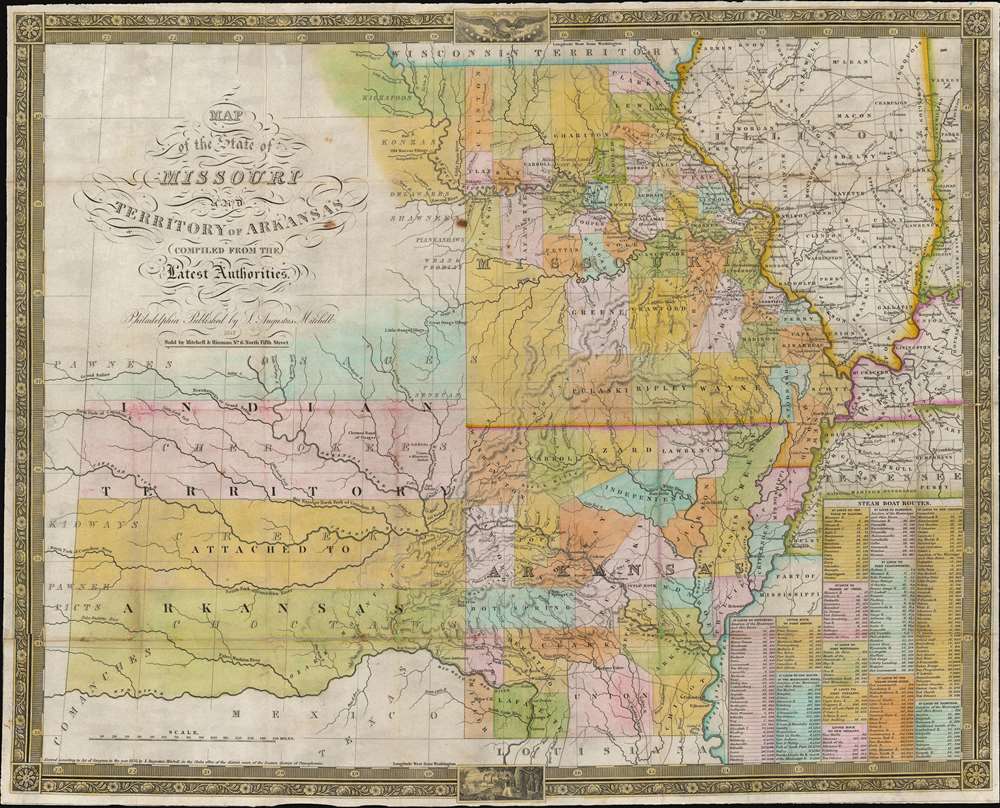
Map of the State of Missouri and Territory of Arkansas.
1837 (dated) 17.5 x 22 in (44.45 x 55.88 cm) 1 : 2200000
1837 (dated) 17.5 x 22 in (44.45 x 55.88 cm) 1 : 2200000
Description
This is an 1837 Samuel Augustus Mitchell map of Missouri and Arkansas. Depicting the region from the Indian Territory to Illinois and the Mississippi River, counties, cities, and towns are illustrated and labeled. Mitchell also places an emphasis on modern transportation networks: roads crisscross the states and tables of steam boat routes occupy the lower right corner.
The Advance of History
During the 1820s and 1830s, much of the western United States experienced incredible geographical changes, sometimes rapidly, and this region was no different. Published the year after Arkansas was admitted to the Union, this map attempts to reflect the new geographical reality, while at the same time remaining profitable for its publisher. Mitchell has made the map reflect Arkansas's statehood, but still states that the Indian Territory is attached to Arkansas. However, that territory was separated from Arkansas in 1824, with more territory subsequently removed from the Arkansas Territory in 1828. The title also reflects some lethargy in updates, since it still reads 'Territory of Arkansas'.Why Not Change Everything?
In the 19th century, changing printed materials, particularly maps, was an expensive proposition. Likely, Mitchell copyrighted the map in 1835, as the copyright date suggests. Then, he published the map in 1836 (the first traceable edition of this map), but with changes to the borders to reflect Arkansas's statehood. As stated above, copyrights were expensive, and it was common, particularly for atlas publishers, to change the maps but not change the copyrights. If Mitchell had copyrighted this map only shortly before Arkansas became a state, and wanted to change the title, he likely would have had to pay for a new copyright. Thus, Mitchell likely made the decision to reflect the correct geography, at least to the best of his ability, but not change the title or the copyright.Publication History and Census
This map was created and published by Samuel Augustus Mitchell in 1837. This is the only known example of the 1837 edition. An example of the 1836 edition is part of the David Rumsey Map Collection.Cartographer
Samuel Augustus Mitchell (March 20, 1792 - December 20, 1868) began his map publishing career in the early 1830s. Mitchell was born in Bristol, Connecticut. He relocated to Philadelphia in 1821. Having worked as a school teacher and a geographical writer, Mitchell was frustrated with the low quality and inaccuracy of school texts of the period. His first maps were an attempt to rectify this problem. In the next 20 years Mitchell would become the most prominent American map publisher of the mid-19th century. Mitchell worked with prominent engravers J. H. Young, H. S. Tanner, and H. N. Burroughs before attaining the full copyright on his maps in 1847. In 1849 Mitchell either partnered with or sold his plates to Thomas, Cowperthwait and Company who continued to publish the Mitchell's Universal Atlas. By about 1856 most of the Mitchell plates and copyrights were acquired by Charles Desilver who continued to publish the maps, many with modified borders and color schemes, until Mitchell's son, Samuel Augustus Mitchell Junior, entered the picture. In 1859, S.A. Mitchell Jr. purchased most of the plates back from Desilver and introduced his own floral motif border. From 1860 on, he published his own editions of the New General Atlas. The younger Mitchell became as prominent as his father, publishing maps and atlases until 1887, when most of the copyrights were again sold and the Mitchell firm closed its doors for the final time. More by this mapmaker...
Condition
Good. Laid down on archival tissue with some minor fill repairs a a few fold intersections. Removed from but accompanied by original binder.
References
OCLC 23277889 (1838).