This item has been sold, but you can get on the Waitlist to be notified if another example becomes available, or purchase a digital scan.
1808 Direccion Hidrograficos Plan of Mobile Bay, Alabama
MobileBay-direccionhidrograficos-1808$425.00

Title
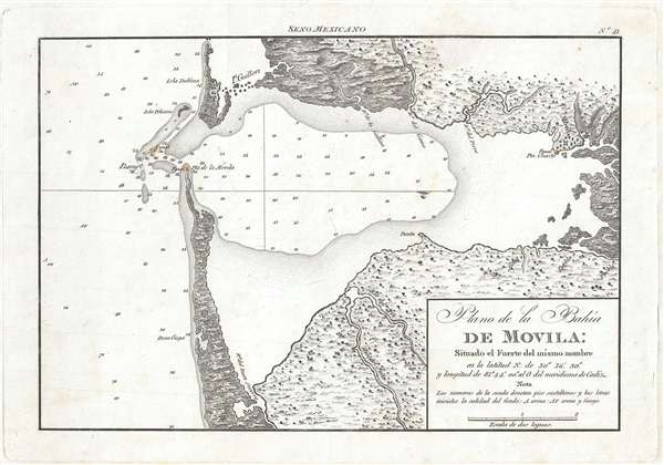
Plano de la Bahía de Movila Situado el Fuerte del mismo nombre en la latitud N. de 30º 36'' 30. y longitud de 81º 44' 00'' al O. del meridiano de Cádiz.
1809 (undated) 7.5 x 11 in (19.05 x 27.94 cm) 1 : 226750
1809 (undated) 7.5 x 11 in (19.05 x 27.94 cm) 1 : 226750
Description
A stunning and rare 1809 map of Mobile Bay, Alabama by the Spanish maritime cartographic agency, La Dirección Hidrográfica. Oriented to the west, this map covers all of Mobile Bay from the French city of Mobile to the entrance to the Bay and from Dauphin Island to Oyster Bay. The map identifies lights at the entrance to the Bay and provides depth soundings throughout. There is some inland detail, particularly along the river systems that drain into the Bay.
This map was published in 1809 by La Dirección Hidrográfica as part of the magnificent four part Portulano de la America Setentrional. The cartography is based upon earlier Spanish and French exploration of the Bay. This map is very rare and one of the earliest high quality scientific mappings of Mobile Bay.
This map was published in 1809 by La Dirección Hidrográfica as part of the magnificent four part Portulano de la America Setentrional. The cartography is based upon earlier Spanish and French exploration of the Bay. This map is very rare and one of the earliest high quality scientific mappings of Mobile Bay.
Cartographer
The Direccion Hidrografía (1787 - 1927), also known as the Deposito Hydrografico and the Direction de Hidrografía, was the Spanish equivalent of the British Admiralty or the U.S. Coast Survey. This organization, founded in 1787, was commissioned to collect and produce accurate nautical charts of all waters frequented by Spanish vessels. In essence, it replaced the Casa de la Contratación de las Indias (House of Trade of the Indies), which closed its doors in 1790. Like most such organizations, the Direccion Hidrografía marked a new age in cartography. Rather than simply collect charts created by navigators, explorers, and merchants, the Direccion Hidrografía worked closely with naval and military personnel to mount cartographic and hydrographic expeditions in pursuit of the most accurate hydrographical, astronomical, and geodetic measurements. The Direccion Hidrografía created a massive library of nautical charts that, though not nearly as common as similar nautical charts by the U.S. Coast Survey and British Admiralty, are highly desirable for the beauty of their manufacture as well as their accuracy and detail. The office was originally located on Calle Ballesta, but relocated to 36 Alcala, both in Madrid. After 1908 the Dirección was subsumed into other governmental agencies. In 1927 the Direccion was absorbed into the Institute and Observatory of San Fernando, located in Cadiz. The library of original maps, charts, and journals was transferred to the Naval Museum of Madrid - where it resides to this day. More by this mapmaker...
Source
Portulano de la America Setentrional (Madrid: Dirección Hidrográfica), 1809.
Condition
Very good. Light foxing.
References
OCLC 733637289.