This item has been sold, but you can get on the Waitlist to be notified if another example becomes available, or purchase a digital scan.
1954 Hayden Map Co. Map of the Mammoth Lakes Dist. and Yosemite, NP, California
MonoCounty-haydenmapco-1954$187.50

Title
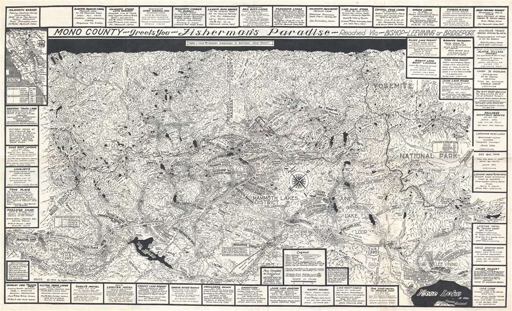
Mono County - Greets You - Fisherman's Paradise - Reached Via - Bishop - Lee Vining or Bridgeport.
1954 (dated) 16.5 x 27.75 in (41.91 x 70.485 cm) 1 : 126720
1954 (dated) 16.5 x 27.75 in (41.91 x 70.485 cm) 1 : 126720
Description
This is a 1954 Emmett Hayden map of the Mammoth Lakes district of southern Mono County, California, situated in the eastern Sierra Nevada Mountains near Yosemite National Park. The map depicts the region from Paradise Camp located on U.S. 395 to Saddlebag Lake in Yosemite and from Isberg Pass to Mono Lake and Lee Vining. Beautifully illustrated, this tourist map highlights the many activities a visitor to the area could enjoy and the many places they could potentially stay. Some of these include the Timber Ridge Resort, the Tamarack Lodge, the Convict Lake Resort and the Lakeview Motel. Myriad lakes of all sizes are included, and their elevations are noted, as are those of the mountain peaks that are also labeled throughout. Yosemite National Park is situated along the right border, and it appears to continue off the right side of the map.
A true tourist map, distances from locations in the region, such as Lee Vining and Paradise Camp, are also included to give potential visitors some idea of how far they would have to travel. An inset map of the states of California and Nevada is situated in the upper right corner, allowing the viewer to better orient themselves as to where in California the Mammoth Lakes and Yosemite National Park are in relation to San Francisco, Los Angeles, and San Diego. Advertisements for local businesses frame the map, allowing these businesses to promote themselves, since they were apparently the ones who paid for the map's production.
This map was created by Emmett Hayden and published by the Hayden Map Company of Glendale, California in 1954.
Cartographer
Emmett Hayden (fl. c. 1925 - 1960s) was a California cartographer based near Los Angeles. The founder of the Hayden Map Company, he started his map-making career mapping sub-divisions in the Los Angeles area. Then, in 1927, Hayden secured a lease from the National Park Service to build a hunting and fishing cabin in the Mammoth Lakes region. He then spent from 1927 until 1937 building his cabin from local materials entirely by hand. Hayden eventually spent most of his time at the cabin as a hunting and fishing guide and continued making maps, but in support of his new business. The Margaret and Emmett Hayden Cabin still stands today and serves as the Mammoth Lakes Museum. More by this mapmaker...
Condition
Very good. Light wear along original fold lines. Small area of infill. Closed tear extending 1.5 inches into printed area from bottom margin professionally repaired on verso. Blank on verso.
References
OCLC 1061969480.