This item has been sold, but you can get on the Waitlist to be notified if another example becomes available, or purchase a digital scan.
1838 Karacsay Map of Montenegro
Montenegro-karacsay-1838$750.00

Title
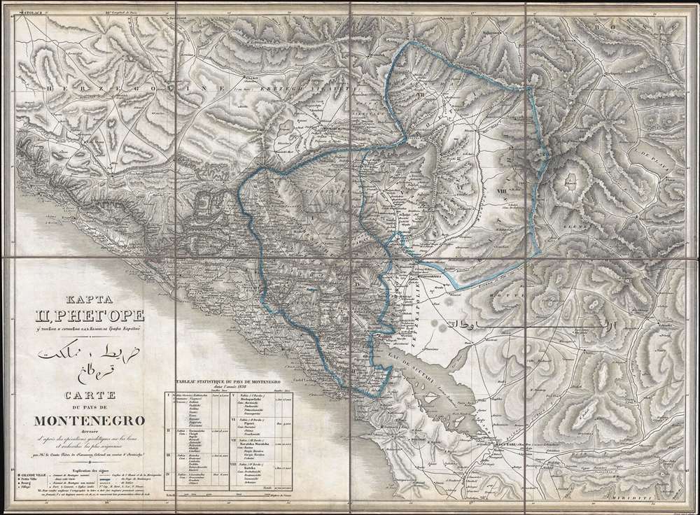
КАРТА ЦРНЕГОРЕ. قرطاغ مملكت خريط. Carte du Pays de Montenegro dressée d'après des opérations géodétiques sur les lieux et recherches les plus soigneuses.
1838 (undated) 17.5 x 23.75 in (44.45 x 60.325 cm) 1 : 280000
1838 (undated) 17.5 x 23.75 in (44.45 x 60.325 cm) 1 : 280000
Description
This is an 1838 Count Fedor von Karacsay tri-lingual map of Montenegro - considered the first broadly accurate map of Montenegro. The map is a product of Montenegrin Vladika Petar II Petrović-Njegoš's ongoing efforts to modernize and reform Montenegro.
Despite tense relations between Montenegro and Austria, Fedor von Karacsay, the Austrian military commander of Cattaro (Kotor), and the Montenegrin Vladika Petar II Petrović-Njegoš became close friends. Petrović-Njegoš was a polymathic poet, statesman, and progressive leader who planned and implemented civic reforms and infrastructure development throughout the country. In this spirit, he allowed Karacsay to undertake the surveys that serve as the basis of this map.
Karacsay's remarkable surveys resulted in exceptionally detailed regional topography, with roads, rivers, and lakes clearly presented. A key in the lower left explains the notations used to identify forts, convents, and churches. Near the map key, the Tableau Statistique du Pays de Montenegro offers census data. Most of the map is printed in French (then the premier Pan-European intellectual language), but the title is also in Serbo-Montenegrin and Ottoman Turkish.
A Closer Look
When this map was produced, Montenegro was an autonomous region of the Ottoman Empire. The area here covered is smaller than modern Montenegro, as the adjacent coastlines of Dalmatia were under Austrian control, while Bosnia, Herzegovina, and Albania were under direct Ottoman administration. Coverage thus embraces from Ragusa (Dubrovnik) to Scutari (Shkoder) and is centered on the Prince-Bishopric of Montenegro.Despite tense relations between Montenegro and Austria, Fedor von Karacsay, the Austrian military commander of Cattaro (Kotor), and the Montenegrin Vladika Petar II Petrović-Njegoš became close friends. Petrović-Njegoš was a polymathic poet, statesman, and progressive leader who planned and implemented civic reforms and infrastructure development throughout the country. In this spirit, he allowed Karacsay to undertake the surveys that serve as the basis of this map.
Karacsay's remarkable surveys resulted in exceptionally detailed regional topography, with roads, rivers, and lakes clearly presented. A key in the lower left explains the notations used to identify forts, convents, and churches. Near the map key, the Tableau Statistique du Pays de Montenegro offers census data. Most of the map is printed in French (then the premier Pan-European intellectual language), but the title is also in Serbo-Montenegrin and Ottoman Turkish.
Publication History and Census
This map was created by Count Fedor von Karacsay, engraved by Pietro Allodi, and published in late 1838. The present example is the first edition; a second edition was published in 1854 in Vienna by Artaria. This is a rare find, as we have been unable to locate another example in recent market history. We have located six examples of the first edition in collections at the U.K. National Archives, Biblioteca Teresiana (Mantova), Charles University (Prague), Muzeum Brněnska (Brno), Bayerische Staatsbibliothek (Munich), and the University of Illinois at Urbana-Champaign.Cartographer
Fedor von Karacsay (1787 - 1859) was a Hungarian cartographer, artist, and adventurer. A member of a Hungarian noble family, little is known about his childhood, though records show that he was a graduate of the Theresianum, a prestigious Austrian military academy in Wiener Neustadt. He as a cadet in the Austrian army by 1805 and held the rank of lieutenant while serving at the 1813 Battle of Dresden, a major engagement during the Napoleonic Wars. Early in his military career, Karacsay received formal training in military engineering and advanced survey methods. A remarkable soldier who had distinguished himself due to his ability and drive, he had been promoted to the rank of colonel by the 1830s and was given the highly important post of garrison commander of Cattaro (Kotor). Located on the Bay of Kotor not far from the Dalmatian coast, the city was a flashpoint in the region, since it was an Austrian-controlled port city with a majority Slavic population. Montenegro openly coveted the city, and, while open warfare never broke out between the Montenegrins and the Austrians, relations were always tense at best. Karacsay, however, had a kind and genial demeanor that endeared him to the locals, as did the reality of his time as garrison commander, which was gentler and more culturally sensitive than that of his predecessors. Despite the tension and near hostility between the two nations, Karacsay was invited to visit the court of the Montenegrin vladika Petar II Petrović-Njegoš in Cetinje in 1836. The two became fast friends and formed a lasting friendship that transcended national rivalries. It was because of this relationship that Karacsay was able to complete and publish the first scientific survey of the interior of Montenegro. After his tour of duty in Kotor ended, Karacsay was posted throughout the world, including as the head of the Habsburg mission in Belgrade and as special envoy to Sultan Abdülmecid I in Constantinople. Due to this intellect and capacity for writing, Karacsay published several travel books about his journeys. By the early 1850s, Karacsay was posted in Brno, and later Budapest, where he developed a fascination for Pan-Turanism, the idea that Hungarians share a common ancestry with the Turkic peoples as well as other Asiatic ethnic groups. In his desire to find these links between Hungarian and Asian cultures, he traveled to Herat, Balkh, Bohara, and Samarkand. Karacsay died in Tehran in 1859 holding the rank of General. More by this mapmaker...
Condition
Very good. Dissected and mounted on original linen in 8 panels. Even overall toning. Accompanied by original slipcase.