1862 Matz Map of the American Civil War Siege of Corinth, Mississippi
MontereyCorinth-matz-1862$500.00

Title
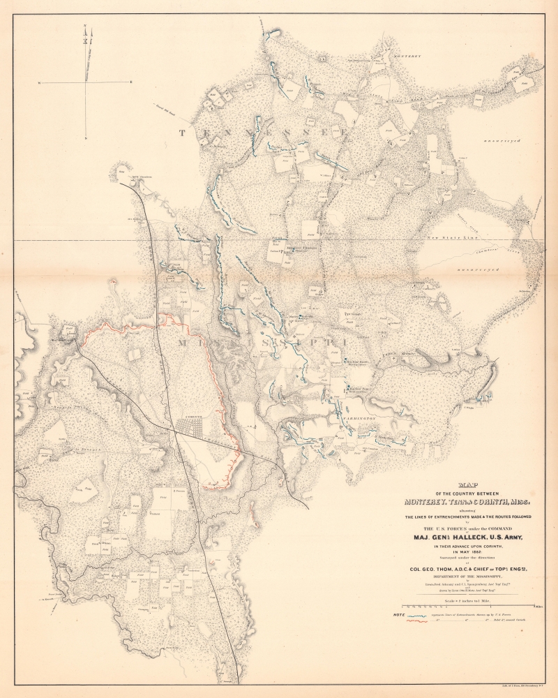
Map of the Country Between Monterey, Tenn. And Corinth,Miss. Showing the Lines of Entrenchments Made and the Routes Followed by the U.S. Forces under the Command of Maj. Gen'l. Halleck, U.S. Army, in Their Advance Upon Corinth, in May 1862.
1862 (dated) 30.5 x 24.75 in (77.47 x 62.865 cm) 1 : 31680
1862 (dated) 30.5 x 24.75 in (77.47 x 62.865 cm) 1 : 31680
Description
This is a separate issue 1862 Otto H. Matz map of American Civil War troop movements leading to the capture of Corinth, Mississippi, in May 1862. The map depicts from Cane Creek and the Tuscumbia River to Springer, Tennessee and Johnston, Mississippi and from Monterey, Tennessee to the George homestead in Mississippi.
Beauregard, in a brilliant tactical move, tricked the Union commanders and managed to spirit away his army by night by giving some of his men three days' rations and ordering them to prepare for an attack. This order, as expected, made its way to Union forces by way of a spy. Beauregard then launched an artillery bombardment, a move that usually preceded a battle. However, instead of fighting, on the night of May 29, Beauregard withdrew his army to Tupelo, Mississippi, and took advantage of the Mobile and Ohio Railroad to evacuate the sick and wounded, using fake campfires and dummy guns in the defensive works to maintain the ruse. When Union patrols entered Corinth of May 30, they found the city deserted. Beauregard and his army had lived to fight another day.
A Closer Look
Illustrating the advance of the three armies under General Halleck's command, routes from Monterey, Tennessee, to Corinth are labeled, along with waypoints between the two towns where each army constructed fortifications. Both Union (blue) and Confederate (red) fortifications are illustrated. Fields and homesteads throughout are illustrated, underscoring how the Civil War invaded the lives of civilians, particularly in the South.The Siege of Corinth, or the First Battle of Corinth
Influenced by the heavy losses at Shiloh, Halleck ordered his men to fortify positions all along their route, in case of a surprise attack by Confederate forces, but making for a 'tedious' advance. Eventually Halleck reached Corinth, Mississippi, an important rail junction where the Mobile and Ohio Railroad and the Memphis and Charleston Railroad met. Rail transportation played an integral role throughout the entire Civil War, making rail junctions, like the one at Corinth, important strategic targets for both sides. The Confederate commander at Corinth, General P.G.T. Beauregard, knew that his force was outnumbered and suffering from disease. This made the effective defense of the city nearly impossible and could lead to the utter destruction or capture of his army.Beauregard, in a brilliant tactical move, tricked the Union commanders and managed to spirit away his army by night by giving some of his men three days' rations and ordering them to prepare for an attack. This order, as expected, made its way to Union forces by way of a spy. Beauregard then launched an artillery bombardment, a move that usually preceded a battle. However, instead of fighting, on the night of May 29, Beauregard withdrew his army to Tupelo, Mississippi, and took advantage of the Mobile and Ohio Railroad to evacuate the sick and wounded, using fake campfires and dummy guns in the defensive works to maintain the ruse. When Union patrols entered Corinth of May 30, they found the city deserted. Beauregard and his army had lived to fight another day.
Publication History and Census
This map was surveyed by Frederick Schraag and Charles Spangenberg, drawn by Otto H. Matz, and published in 1862. While well represented in institutional collections, this map is rarely seen on the private market.CartographerS
Otto H. Matz (March 8, 1830 - March 8, 1919) was an American architect and an American Civil War veteran. Born in Berlin, Matz arrived in Chicago in 1854 and became an architect for the Illinois Central Railroad and the Chicago and Alton Railroad. Matz designed the first Union Station built in Chicago, that was unfortunately destroyed by the great Chicago fire of 1871. He served as an engineer in the Union Army during the American Civil War, during which he was a member of the staffs of Generals Fremont, Hallock, and Grant. He worked on the plans fro the capture of Vicksburg and entered the city with General Grant. After the war, Matz returned to Chicago and acted as the school architect of Chicago from 1869 until 1871. After the Chicago fire, Matz participated in the competition for a contract to construct the new city hall and county buildings and won first prize, though he was not awarded the contract. In 1892, Matz was the County Architect and was responsible for building the criminal court building. Matz married Mary Elizabeth Lewis on October 26th, 1857, with whom he had two sons and a daughter. Matz's obituary in the Chicago Tribune that three of his grandsons served in World War I. More by this mapmaker...
Charles Spangenberg(fl. c. 1862 - 1872) was a topographical draftsman active in the mid to late 19th century. Spangenberg served with the Union Army during the American Civil War (1861 - 1865). His name is attached to at least one important Civil War manuscript maps, of the Battle of Vicksburg, as well as published maps of multiple other battles. After the war, he was active in New York City, where he drew several maps for the New York Parks Commission. Learn More...
Julius (Julien) Bien (September 27, 1826 - December 21, 1909) was a German-Jewish lithographer and engraver based in New York City. Bien was born in Naumburg, Germany. He was educated at the Academy of Fine Arts, Cassell and at Städel's Institute, Frankfurt-am-Main. Following the suppression of the anti-autocratic German Revolutions of 1848, Bien, who participated in the pan-German movement, found himself out of favor in his home country and joined the mass German immigration to the United States. Bien can be found in New York as early as 1849. He established the New York Lithographing, Engraving & Printing Company in New York that focused on the emergent chromo-lithograph process - a method of printing color using lithographic plates. His work drew the attention of the U.S. Government Printing Office which contracted him to produce countless government maps and surveys, including the Pacific Railroad Surveys, the census, numerous coast surveys, and various maps relating to the American Civil War. Bien also issued several atlases both privately and in conjunction with a relation, Joseph Bien. At the height of his career Bien was elected president of the American Lithographers Association. After his death in 1909, Bien's firm was taken over by his son who promptly ran it into insolvency. The firm was sold to Sheldon Franklin, who, as part of the deal, retained the right to publish under the Julius Bien imprint. In addition to his work as a printer, Bien was active in the New York German Jewish community. He was director of the New York Hebrew Technical Institute, the New York Hebrew Orphan Asylum, and president of the B'nai B'rith Order. Learn More...
Condition
Very good. Light wear and toning along original fold line. Closed minor margin tear professionally repaired on verso.
References
LOC G3984.C8S5 1862 .M3. Stephenson, R. W., Civil War Maps; an Annotated List of Maps and Atlases in Map Collections of the Library of Congress, 267. OCLC 51744377.