1913 Denny Pocket Survey Map of Monterey County, California
MontereyCounty-denny-1913$500.00


Title
Denny's pocket map of Monterey County, California.
1913 (dated) 24 x 29 in (60.96 x 73.66 cm) 1 : 235000
1913 (dated) 24 x 29 in (60.96 x 73.66 cm) 1 : 235000
Description
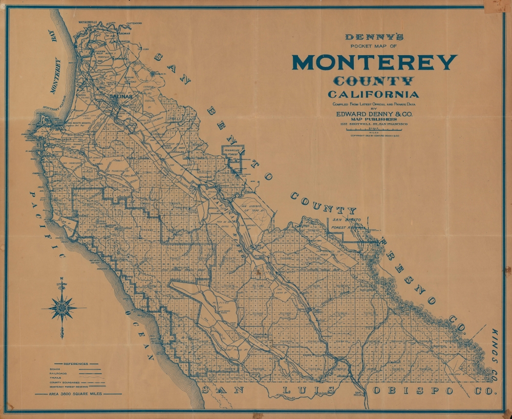
A detailed 1913 survey map of Monterey County, California by Edward Denny and Co. It depicts the region in the latter stages of a transition from large rancheros to small land holdings.
Along the coast, particularly on and around the Monterey Peninsula, a dual economy of fishing and tourism developed. Having already built a reputation as a refuge for artists, writers, and bohemians, Monterey, Carmel, and surrounding communities became a resort for the elite of California and beyond, a development represented, and in many ways launched, by the construction of the large and luxurious Hotel Del Monte in 1880.
A Closer Look
The entire county is displayed, from the Pajaro River at north to the border of San Luis Obispo County at south and eastwards through the Salinas Valley to the adjoining hills (the Gabilan Range), including Pinnacles Forest Reserve (now a National Park). Numerous ranchos (abbreviated as 'Ro.') of the Spanish and Mexican eras remain, mostly but not exclusively in the Salinas Valley. In addition to ranchos and survey lines, roads, trails, rivers, mountains, and towns are indicated.Making Monterey
When this map was published, both the coastal and interior regions of Monterey County were undergoing important changes. In the agricultural interior, particularly the Salinas Valley, the large land grant ranchos were increasingly split up and bought by individual families or agricultural enterprises. The arrival of the Southern Pacific Railroad was a boon to the industry, allowing farms to sell their products at markets in San Francisco and other cities to the north. New towns sprang up along the railroad nearly overnight, including King City, near center. This area and period were a frequent setting for the novels of John Steinbeck, who grew up in the Salinas Valley in the early 20th century, and whose father claimed to be the first resident of King City (he later became the County Treasurer).Along the coast, particularly on and around the Monterey Peninsula, a dual economy of fishing and tourism developed. Having already built a reputation as a refuge for artists, writers, and bohemians, Monterey, Carmel, and surrounding communities became a resort for the elite of California and beyond, a development represented, and in many ways launched, by the construction of the large and luxurious Hotel Del Monte in 1880.
Publication History and Census
This map was published in 1913 by Edward Denny of San Francisco. It is scarce to the market and only noted among the holdings of Stanford University, the California Historical Society, the Los Angeles Public Library, and several campuses of the University of California (Berkeley, Davis, Santa Barbara, and Riverside).Cartographer
Edward Denny and Co. (fl. c. 1853 - 1935), not to be confused with a wool factory in Massachusetts of the same name, was a map publisher based in San Francisco. Information about the company is scarce and its early history is especially mysterious, with the firm being listed as a publisher on some maps as early as the 1850s. At any rate, the company became more prolific in the closing years of the 19th century, focusing on plat maps of cities and counties in California, and is best known for its pocket maps of various California counties. More by this mapmaker...
Condition
Good. Evenly toned. Minor areas of loss infilled on verso at fold intersections. Closed margin tears professionally repaired on verso. Chips and stains in margin and along edge. Original fold lines visible.
References
OCLC 23091097, 380665018.