
This item below is out of stock, but another example (left) is available. To view the available item, click "Details."
Details
1899 Panoramic View Map 'Route of the Mormon Pioneers' (Nebraska, Utah, Wyoming)
$1,300.00
1899 Panoramic View Map 'Route of the Mormon Pioneers' (Utah, Wyoming)
MormonPioneers-millroyhayes-1899-3$1,125.00


Title
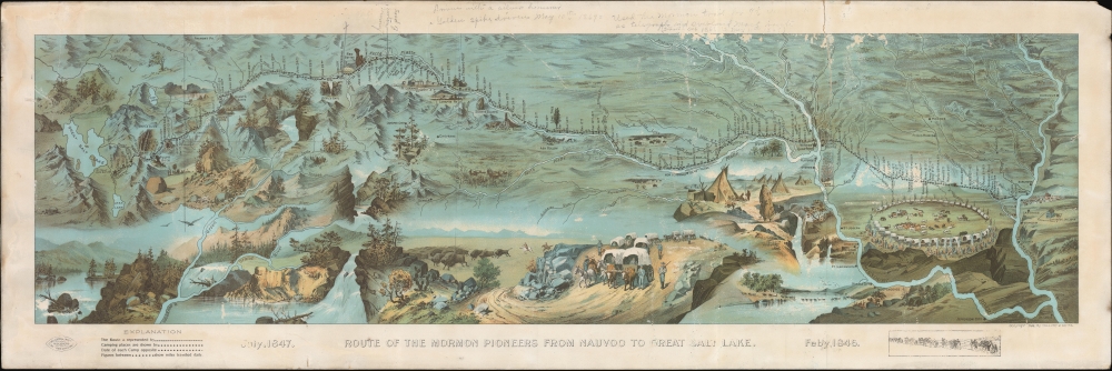
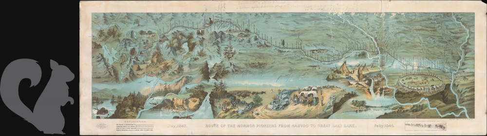
Route of the Mormon Pioneers from Nauvoo to Great Salt Lake.
1899 (dated) 14 x 41.5 in (35.56 x 105.41 cm) 1 : 3800000
1899 (dated) 14 x 41.5 in (35.56 x 105.41 cm) 1 : 3800000
Description
This is a striking 1899 chromolithograph panoramic Millroy and Hayes bird's-eye view and map of the 1,300-mile Mormon Trail. The view covers the region between the Mississippi River and Great Salt Lake and chronicles the westward migration of the Mormon Pioneers from Nauvoo, Illinois, to Great Salt Lake, Utah, 1846-1847.
The trek westward began on February 4, 1846. After crossing the Mississippi River at Nauvoo, the journey passed through the Iowa Territory following early explorer's routes and Native American paths. Rain, mud, swollen rivers, and poor preparation plagued the trip. Heavy rains turned the rolling plains of southern Iowa into a quagmire of axle-deep mud. Furthermore, few people carried adequate provisions. The weather, general unpreparedness, and lack of experience in moving such a large group contributed to the extreme hardship for which this voyage is known. The Latter-Day Saints wintered on the Missouri River at a camp called 'Winter Quarters' before pressing on to Fort Laramie. From Laramie, the pioneers began the arduous ascent to South Pass, where they crossed the Rocky Mountains and descended into the Great Basin. They arrived at Great Salt Lake in July 1847. One year later, in 1848, at the end of the Mexican-American War (1846 - 1848), the Great Basin, and indeed the entirety of the American West, was ceded to the United States by the Treaty of Guadeloupe-Hidalgo.
A Closer Look
The view details part of the modern-day states of Iowa, Nebraska, Wyoming, and Utah. The day-to-day progression of the pioneers is accompanied by dramatic vignettes illustrating wagon trains, circled wagons at night, Indian tepees, the Mormon Battalion, and other western scenery. The map and events depicted are derived from the journals of Orson Pratt and his brother Parley P. Pratt, original members of the 'Quorum of Twelve Apostles'.Mormon Trail
The Mormon Trail extends from Nauvoo, Illinois, which was the principal settlement of the Latter Day Saints from 1839 to 1846, to Salt Lake City, Utah, which was settled by Brigham Young and his followers beginning in 1847. From 1838 to 1846, most Mormons had settled in Nauvoo, Illinois, under the leadership of Brigham Young. Tensions between the newly arrived Mormons and established Nauvoo residents led to the eviction of Mormons via the Quincy Convention of 1845, which demanded that all Mormons withdraw from Nauvoo by 1846. Consulting trappers and frontiersmen, Brigham Young settled on the Great Salt Lake, then part of Mexico, as their final settlement.The trek westward began on February 4, 1846. After crossing the Mississippi River at Nauvoo, the journey passed through the Iowa Territory following early explorer's routes and Native American paths. Rain, mud, swollen rivers, and poor preparation plagued the trip. Heavy rains turned the rolling plains of southern Iowa into a quagmire of axle-deep mud. Furthermore, few people carried adequate provisions. The weather, general unpreparedness, and lack of experience in moving such a large group contributed to the extreme hardship for which this voyage is known. The Latter-Day Saints wintered on the Missouri River at a camp called 'Winter Quarters' before pressing on to Fort Laramie. From Laramie, the pioneers began the arduous ascent to South Pass, where they crossed the Rocky Mountains and descended into the Great Basin. They arrived at Great Salt Lake in July 1847. One year later, in 1848, at the end of the Mexican-American War (1846 - 1848), the Great Basin, and indeed the entirety of the American West, was ceded to the United States by the Treaty of Guadeloupe-Hidalgo.
Chromolithography
Chromolithography, sometimes called oleography, is a color lithographic technique developed in the mid-19th century. The process uses multiple lithographic stones, one for each color, to yield a rich composite effect. Generally, a chromolithograph begins with a black basecoat upon which subsequent colors are layered. Some chromolithographs used 30 or more separate lithographic stones to achieve the desired effect. Chromolithograph color can be blended for even more dramatic results. The process became extremely popular in the late 19th and early 20th centuries when it emerged as the dominant method of color printing. The vivid color chromolithography made it exceptionally effective for advertising and propaganda.Publication History and Census
There are two known editions of this view map, small and large, both of which have become extremely rare. The present example, published by Millroy and Hayes in 1899, corresponds to the larger example. Most known issues of the larger print were prepared in folding format and were accompanied by a 31-page booklet entitled Guide to the route map of the Mormon pioneers from Nauvoo to Great Salt Lake, 1846-1847. The present offering, however, is a large format presentation issue that was clearly never folded. It is printed on heavy stock without an accompanying booklet. The second issue, about 1/3 the size of this first edition, was prepared by the New Wilson European Hotel and issued later in 1899. The map is well represented in institutional collections but scarce to the market.Cartographer
Millroy and Hayes (fl. c. 1899) were Salt Lake City based printers active in the late 19th century. They are best known for their panoramic birds-eye view illustrating the route of the Mormon Pioneers. No other publications by this firm have been recorded. More by this mapmaker...
Condition
Average. Some image loss due to scuffing. Large tear extending from the upper margin about 6 inches into the page - stabilized on verso with archival linen tape. Pencil marks on map and in margin. Priced accordingly - normally a 4K piece.
References
OCLC 853077855.