This item has been sold, but you can get on the Waitlist to be notified if another example becomes available.
1940 / 1957 GUGK / CIA City Plan of Moscow
MoscowCIA-gugk-1957$125.00


Title
Moscow.
1957 (dated) 25.5 x 30.5 in (64.77 x 77.47 cm) 1 : 35000
1957 (dated) 25.5 x 30.5 in (64.77 x 77.47 cm) 1 : 35000
Description
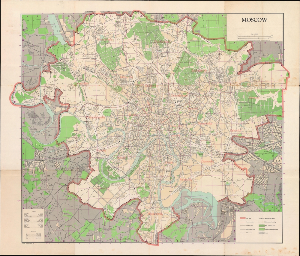
A large and impressive 1957 map of Moscow, produced by the Central Intelligence Agency using a 1940 Russian-language original produced by the Soviet Main Administration of Geodesy and Cartography (G.U.G.K) as a basis.
A Closer Look
Moscow is displayed with city limits traced in thick red lines, and divisions between rayons (districts) in thin red lines. Rayons, roads, railroad lines and train stations, parks, cemeteries, airports, and other features are labelled throughout. Several elements have been added to the 1940 original (which is held by the David Rumsey Historical Map Collection, List No. 13384.001). For example, just south of Frunzenskiy are the Sparrow Hills (Vorob'yevy Gory), curiously retaining their original name here rather than the contemporary 'Lenin Hills.' Located there is the Central Lenin Stadium (now Luzhniki Stadium) that was built in 1955-1956, which was not present on the original 1940 map. Conversely, the site of the massive, unrealized Palace of the Soviets (Дворец Советов) project, noted (and illustrated in an inset) on the 1940 original, is a conspicuously blank space southwest of the Kremlin here. The CIA translators have also added a glossary and list of abbreviations at bottom-left.Making Modern Moscow
The Soviet capital grew substantially and changed dramatically in the Stalin and early Khruschev eras. In addition to the features mentioned above, the city also developed an impressive metro system beginning in 1935, not indicated on the map. But the city faced a severe housing shortage in the immediate postwar years. After considering various possibilities, Soviet architects and urban planners decided on pre-fabricated concrete-paneled apartment buildings that came to be known as khrushchevka, after the Soviet leader who was chief of the Party in Moscow before becoming First Secretary of the Communist Party in 1953. Meant to be a temporary solution to the housing shortage until the fruits of Communist delivered plentiful housing for all, the buildings proliferated in the 1950s and 1960s across the Soviet Union and became a fixture of Soviet life. Eventually, most of Moscow's population would be housed in khrushchevka, though in recent years many have been demolished and replaced with more modern structures through the ambitious Moscow Urban Renewal Initiative. The growing population and relative improvement in living standards in the 1950s also led to traffic jams throughout the city, prompting the construction of the Moscow Ring Road (MKAD), opened in 1961.Publication History and Census
This map was produced by the Central Intelligence Agency in 1957, using a 1940 Russian-language original (План г. Москвы) by the GUGK (Главное управление геодезии и картографии) as a basis. As noted at bottom-left, this is the second edition of the CIA map, and it was originally accompanied by a booklet including a detailed index (corresponding to the grid here) and other information about the city. The present edition is noted among the holdings of seven institutions in the OCLC, and appears to be quite scarce to the market.Cartographer
Main Administration of Geodesy and Cartography, U.S.S.R. (Главное управление геодезии и картографии, or GUGK; 1939 – 1991) traced its roots to the early years of the Soviet Union, when the Higher Geodetic Administration (Высшее геодезическое управление, VGU) was created to centralize and direct topographic, geodetic, and cartographic work in the new state. However, as a branch office of the Supreme Council of National Economy with little authority and a small staff, it was not able to achieve these lofty goals. In 1925, VGU was moved to the State Planning Commission (Gosplan) and underwent several organizational changes, but problems of coordination persisted. In 1935, the office was placed under the People's Commissariat for Internal Affairs (NKVD) and in 1939 renamed the Main Administration of Geodesy and Cartography (GUGK) under the USSR Council of Ministers, the form it would take until the collapse of the Soviet Union in 1991. With its structure and authority settled, GUGK went on to produce many thousands of maps of the Soviet Union, other territories, and the world in several languages over the course of its existence. The successor to GUGK was the Federal Agency for Geodesy and Cartography (Roskartografiya), which existed from 1991 until 2009, when it was replaced with the Federal Service for State Registration, Cadastre and Cartography (Rosreestr). More by this mapmaker...
Condition
Good. Wear and some toning along folds, with small areas of loss at multiple junctions. Several small tears professionally repaired. Sporadic foxing and uneven toning.
References
OCLC 5677431.