This item has been sold, but you can get on the Waitlist to be notified if another example becomes available, or purchase a digital scan.
1860 Lloyd Map of Mount Vernon, Virginia, George Washington's Home
MountVernonChart-lloyd-1860$1,250.00


Title
Mount Vernon Chart.
1860 (dated) 33.5 x 25.25 in (85.09 x 64.135 cm)
1860 (dated) 33.5 x 25.25 in (85.09 x 64.135 cm)
Description
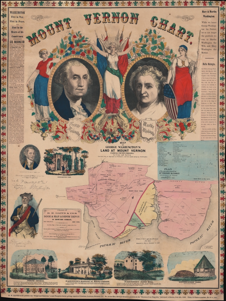
This is H. H. Lloyd's broadside map of Mount Vernon, Virginia, George Washington's home, published only months before the outbreak of the American Civil War (1861 - 1865). Created as a patriotic celebration of the 'Father of his Country', the broadside includes portraits of Martha and George Washington alongside maps of Washington's estate and the surrounding county.
Portraits of George and Martha
Portraits of Martha and George Washington occupy the top half of the sheet, with a personification of victory crowning them with laurel. The figure to the right of Martha holding a spear and a star-spangled shield is Columbia. The figure to the left of George is more enigmatic, but likely represents Freedom. Short texts in the border detail the lives of George and Martha Washington.Two Maps
Below the two portraits, a map of Fairfax County details land ownership in the vicinity of Mount Vernon. Two adjacent parcels, colored yellow, were at the time 'still owned' by Washington's family. The second map, along the right, details Mount Vernon itself with 32 locations marked, including the mansion, dairy, laundry, smoke house, servants' quarters, gardens, and several tombs. A view of Washington's Tomb is situated above and to the left. Four supplemental views appear along the bottom: Pohick Church, Washington's Mansion, Washington's Flour Mill (the last place he went before his death), and a sixteen-sided barn.Publication History and Census
This chart was created and published by H. H. Lloyd and Company in 1860. We note just three cataloged examples: Huntington Library, the University of Michigan, and the American Antiquarian Society.Cartographer
H.H. Lloyd & Company (fl. 1860 - 1890) were 19th century American map and atlas publishers based in New York City. They should not be confused with the competing New York firm with of a similar name, J. T. Lloyd, with whom H. H. Lloyd had a ongoing conflict. The firm was founded by H. H. Lloyd and Benjamin S. Demarest in 1860. The H. H. Lloyd firm published numerous atlases, wall maps, and gazetteers before, during and after the American Civil War. These include some of the best maps of the period, many of which were used as battle plans by various Civil War generals on both sides of the conflict. From various offices around the city, the H.H. Lloyd firm worked with other prominent firms of the period including H. S. Stebbins, Warner and Beers to produce numerous state and county atlases. Around 1880 Demarest took full control of the firm, possibly suggesting that Lloyd either died or retired. Though H. H. Lloyd and Company continued to produce maps well in to the 1880s, the firm lost much of its momentum and eventually, by 1890, closed its doors. H. H. Lloyd is sometimes confused with J. T. Lloyd, another map publisher of the period who produced a small number of United States and regional maps sympathetic to the Confederacy. Both H. H. Lloyd and B. Demarest were Union supporters, Demarest having served as a Major in the Union Army. More by this mapmaker...
Condition
Very good. Full professional restoration. Close margins.
References
Huntington Library 90846. OCLC 881474946, 83540725.