This item has been sold, but you can get on the Waitlist to be notified if another example becomes available, or purchase a digital scan.
1788 Maire Map of the Mouth of the Dnieper River, Crimea (Ukraine)
MouthDnieper-maire-1788$275.00

Title
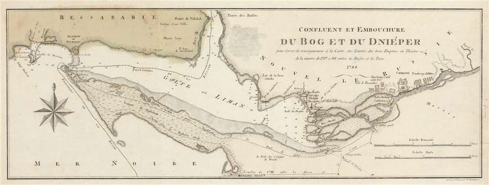
Confluent et Embouchure du Bog et du Dniéper pour Servir de renseignemens à la Carte de Limites de trois Empire ou Théatre de la Guerre de 1787 et 88 entre la Russie et les Turcs.
1788 (dated) 9.5 x 25.5 in (24.13 x 64.77 cm) 1 : 170000
1788 (dated) 9.5 x 25.5 in (24.13 x 64.77 cm) 1 : 170000
Description
This is a 1788 Francois Joseph Maire map of southern Ukraine and Crimea during the first year of the Russo-Turkish War of 1787 - 1792. Depicting the region east of Odessa, the map stretches from the Gulf of Berezan to the Inhulets (Inguol) River and from Bessarabia to the Black Sea. The mouth of the Dnieper River is illustrated just to the right of center, and Russian military encampments are illustrated just up the river around Kherson (Cherson). Numerous depth soundings are noted near the river's mouth and up its course to Kherson. Depth soundings are also present in Dniprovs'ka Gulf (Golfe ou Liman). Two roads are illustrated on the Kinburn (Kinbourne) Peninsula that connect the Kinburn Fortress to a port on the Dnieper. The modern-day cities of Kherson (Cherson) and Ochakiv (Okzakow ou Otchakof) are labeled.
The Russo-Turkish War of 1787 - 1792
Published only a year into the Russo-Turkish War of 1787 - 1792, this map illustrates some of the locations where fighting occurred between September 1787 and mid-1788. The war started because the Russians demanded that the Ottomans give up their land along the Black Sea and evacuate the Crimea, which the Ottomans refused to do. Russia declared war on August 19, 1787, and the Ottomans immediately imprisoned the Russian ambassador. The Ottomans opened the fighting with a series of sea-borne attacks on the fortresses at Kinburn, illustrated here on Kinburn Point, in September and October. The Russians successfully held off both these attacks. Russian troops captured the Ottoman cities of Chocim and Jassy in Moldavia (both of which are not illustrated here) and also laid siege to Ochakiv (Okzakow ou Otchakof). The siege lasted for six months, with Russian forces ultimately capturing the city on December 6, 1788. The Russians continued to have success on the battlefield throughout 1789, 1790, and 1791, with a truce finally agreed upon on July 31, 1791.Publication History and Census
This map was created by Francois Joseph Maire, engraved by Hieronymus Benedicti, and published by Maire in 1788. The OCLC records examples as being part of the collections at Harvard, University College London, Cambridge University, the Bibliothèque Nationale et Universitaire in Strasbourg, France, the University of Bern, and the British Library. This map is extremely rare on the private market.CartographerS
François Joseph Maire (1738 - c. 1800) was a French cartographer, hydrographer, and military engineer based in Vienna and active during the mid- to late-18th century. Believed to have been born one Lorraine in France, Maire published numerous maps and is particularly known for maps made during the Russo-Turkish War of 1787 - 1792, which took place at the same time as the Austro-Turkish War. More by this mapmaker...
Heironymus Benedicti (c. 1756 - c. 1809) was an engraver based in Vienna that was active during the late 18th century. Learn More...
Condition
Very good. Light foxing. Closed margin tear extending one half inch along right margin professionally repaired on verso. Closed tear extending three quarters of an inch into printed area from right margin professionally repaired on verso. Blank on verso.
References
OCLC 911504646.