
This item below is out of stock, but another example (left) is available. To view the available item, click "Details."
Details
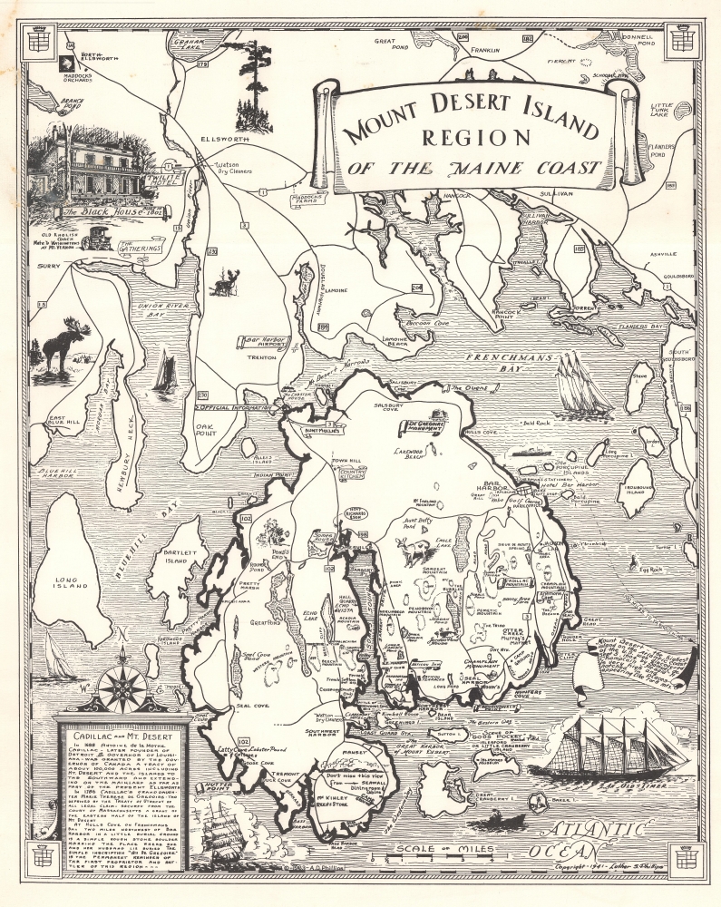
1941 Phillips Pictorial Map of Mount Desert Island, Maine
$600.00
1941 Phillips Pictorial Map of Mount Desert Island, Maine
MtDesertIslandRegion-phillips-1941$200.00

Title
Mount Desert Island Region of the Maine Coast.
1941 (dated) 19 x 15 in (48.26 x 38.1 cm)
1941 (dated) 19 x 15 in (48.26 x 38.1 cm)
Description
This is a rare first edition 1941 Luther S. Phillips pictorial map of Mount Desert Island, Maine. It highlights one of the most popular tourist destinations on the eastern seaboard - Acadia National Park. Philips' maps have been popular since their inception, and variations are still published today, but first editions, as here, are special and scarce.
A Closer Look
Illustrations highlight the region's wildlife and its maritime heritage. Banners mark the most well-known locations, such as Cadillac Mountain and the De Gregoire Monument. Major roads appear and lakes, ponds, monuments, stores, and campgrounds are labeled. A vignette of the Black House occupies part of the upper left corner.Mount Desert Island
Popularized as a vacation destination during the 19th century, Mount Desert Island is renowned for its exceptional natural beauty. First brought to public attention by painters of the Hudson River School, tourists and nature lovers began flocking to the island in the 1860s. By 1880, the island hosted thirty grand hotels. By the 'Gay Nineties', American social elites and business magnates, including the Rockefellers, Fords, Vanderbilts, and Carnegies, built summer homes on the islands' most desirable land. Eventually the Rockefellers acquired most of the island, donating it to the Federal government as a public recreation area, Acadia National Park.Acadia National Park
Mount Desert Island, so named because of its many bald rocky mountaintops, has been a tourist destination since the mid-19th century, when it was discovered by outsiders, artists, journalists, Hudson River School artists, and other patrons, known collectively as the 'Rusticators.' Undaunted by crude accommodations and simple food, they sought out local fishermen and farmers for accommodation and guidance. Summer after summer, the rusticators returned to renew friendships with local islanders and, most of all, to savor the fresh salt air, scenery, and relaxed pace. Soon the villagers' cottages and fishermen's huts filled to overflowing, and by 1880, 30 hotels competed for vacationers' dollars. Tourism was becoming the islands primary industry. Drawing the attention of the wealthy and influential, the island was designated as Sieur de Monts National Monument by President Woodrow Wilson in July 1916. In February 1919, the area's status was officially changed from a National Monument to National Park, making it the first National Park east of the Mississippi River. With the change to a National Park came a name change as well, to Lafayette National Park. It was not until January 1929 that the park was given its current name, Acadia National Park. Acadia is unlike most other National Parks as its creation was encouraged by numerous private individuals. One, John. D. Rockefeller, purchased a summer home in Bass Harbor in 1910. Rockefeller began buying up land on the island with the goal of creating a system of carriage roads to make 'one of the greatest views in the world' accessible to all.Publication History and Census
This map was created and published by Luther S. Phillips in 1941. We note a single cataloged example which is part of the collection of the Osher Map Library at the University of Southern Maine.Cartographer
Luther Savage Phillips (May 10, 1891 - 1960) was an American map maker, photographer, architect, and postcard publisher, and is arguably Maine's most significant pictorial cartographer. Born on Mount Desert Island (Acadia National Park), Maine, Phillips studied at Phillips Andover Academy before spending two years at Yale. He graduated with a Bachelor of Science degree from MIT in 1914. In October 1917 Phillips enlisted in the U.S. Navy as a Coxswain and was commissioned as an Ensign in 1918, when he was sent to the U.S. Naval Academy at Annapolis, Maryland. He was later assigned to the U.S.S. Rhode Island and sailed with the ship on a mission to Archangel on April 11, 1919. After his time in the Navy, Phillips established a successful postcard publishing business and became a well-known pictorial mapmaker. Much of his work focused on the Maine coast in the vicinity of Bar Harbor. Based in Northeast Harbor, Mount Desert Island, Maine, his company, 'Map of Maine' produced local pictorial maps for the tourist market. He would tour the state promoting and selling his work, along with his scenic postcards. After Phillips died in 1960, in Togus, Maine, his brother, Augustus 'Gus' Dewey Phillips (1898 - 1975) took over the map and postcard business, which was then continued by his nephew Donald Phillips (1935 - 2009). In a tragic turn of events, in 1973 an out of control bush fire destroyed the Phillips studio and much of the surviving stock, making all Phillips' maps issued prior to that date rare. Philipps married Olympia Meimari on March 24, 1921 in Annapolis. It is unclear whether Olympia died or the couple divorced, but it is known that Phillips remarried, to Mary J. Merrill in 1935. More by this mapmaker...
Condition
Good. Soiling in upper left quadrant and along top border.
References
University of Southern Maine, Osher Map Library OML-1941-82.