This item has been sold, but you can get on the Waitlist to be notified if another example becomes available, or purchase a digital scan.
1850 Mitchell Comparative Chart of the World's Mountains and Rivers
MtsRvrs2-mitchell-1850$50.00

Title
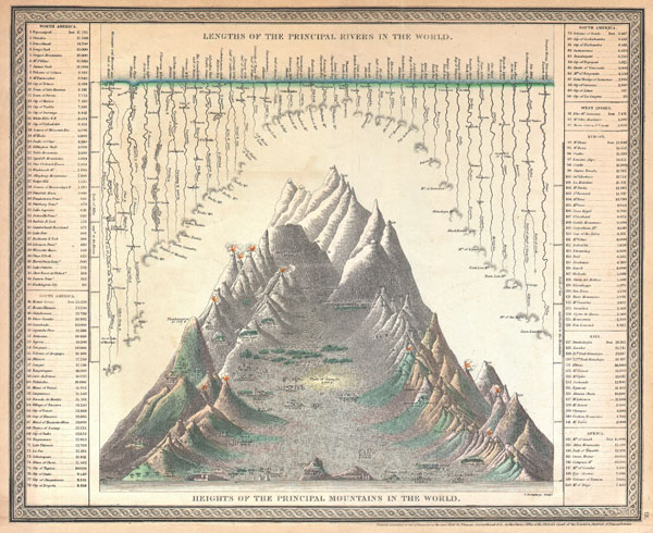
Lengths of the Principal Rivers in the World. / Heights of the Principal Mountains in the World.
1850 (dated) 13 x 16 in (33.02 x 40.64 cm)
1850 (dated) 13 x 16 in (33.02 x 40.64 cm)
Description
A good example of the S. A. Mitchell Sr. / Cowperthwait map of the principal mountains and rivers of the world. Mountains are shown along the bottom of the map with important cities and geological formations noted at their appropriate elevations. Rivers are arrayed along the top of the map descending from the seas to their sources – where known. The Missouri and Mississippi River systems, at 4100 miles, are listed as the world's greatest rivers and Dhaulagiri, at 26, 262 ft., the world's tallest mountain. The mythical 'Mountains of the Moon' are noted as the source of the Nile. Engraved by F. Humphrys for issue as page 75 in the 1850 edition of Mitchell's New Universal Atlas.
Cartographer
Samuel Augustus Mitchell (March 20, 1792 - December 20, 1868) began his map publishing career in the early 1830s. Mitchell was born in Bristol, Connecticut. He relocated to Philadelphia in 1821. Having worked as a school teacher and a geographical writer, Mitchell was frustrated with the low quality and inaccuracy of school texts of the period. His first maps were an attempt to rectify this problem. In the next 20 years Mitchell would become the most prominent American map publisher of the mid-19th century. Mitchell worked with prominent engravers J. H. Young, H. S. Tanner, and H. N. Burroughs before attaining the full copyright on his maps in 1847. In 1849 Mitchell either partnered with or sold his plates to Thomas, Cowperthwait and Company who continued to publish the Mitchell's Universal Atlas. By about 1856 most of the Mitchell plates and copyrights were acquired by Charles Desilver who continued to publish the maps, many with modified borders and color schemes, until Mitchell's son, Samuel Augustus Mitchell Junior, entered the picture. In 1859, S.A. Mitchell Jr. purchased most of the plates back from Desilver and introduced his own floral motif border. From 1860 on, he published his own editions of the New General Atlas. The younger Mitchell became as prominent as his father, publishing maps and atlases until 1887, when most of the copyrights were again sold and the Mitchell firm closed its doors for the final time. More by this mapmaker...
Source
A New Universal Atlas Containing Maps of the various Empires, Kingdoms, States and Republics Of The World. (1850 - 1853 issue)
Condition
Good condition. Some age toning and fading throughout. Blank on verso.
References
Rumsey 0537.001. Phillips 6103.