This item has been sold, but you can get on the Waitlist to be notified if another example becomes available, or purchase a digital scan.
1884 Bradley Map of Montana, Wyoming and Idaho
MTWYID-bradley-1884$125.00

Title
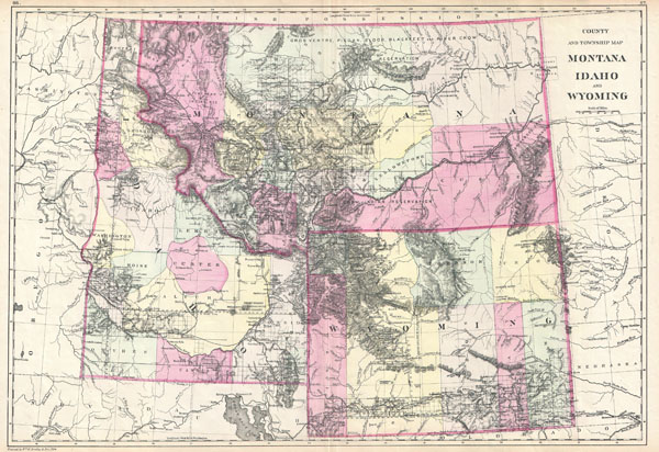
County and Township Map Montana Idaho and Wyoming.
1884 (dated) 15 x 22 in (38.1 x 55.88 cm)
1884 (dated) 15 x 22 in (38.1 x 55.88 cm)
Description
This is the rare 1884 Bradley / Mitchell map of Montana, Idaho, and Wyoming. Covers the territories of Montana, Wyoming, and Idaho in considerable detail with color coding according to counties. Shows American Indian lands, geological formations, forts, cities, maintain passes and river ways. Also notes the progress of the U.S. Land Survey in this region in the form of grids in the surveyed portions of each territory. Includes Yellowstone National Park which was created in 1871. Published by William M. Bradley for inclusion as plates no. 86 and 87 in the 1884 edition of S. A. Mitchell's New General Atlas.
CartographerS
William M. Bradley (fl. 1880 - 1900) was a late 19th century map publisher. The Bradley family were active cartographic publishers whose imprint appears on a number of maps, geographies and atlases. The Bradley firm is best known for its publishing of S. A. Mitchell's important New General Atlas from 1880 - 1887. More by this mapmaker...
Samuel Augustus Mitchell (March 20, 1792 - December 20, 1868) began his map publishing career in the early 1830s. Mitchell was born in Bristol, Connecticut. He relocated to Philadelphia in 1821. Having worked as a school teacher and a geographical writer, Mitchell was frustrated with the low quality and inaccuracy of school texts of the period. His first maps were an attempt to rectify this problem. In the next 20 years Mitchell would become the most prominent American map publisher of the mid-19th century. Mitchell worked with prominent engravers J. H. Young, H. S. Tanner, and H. N. Burroughs before attaining the full copyright on his maps in 1847. In 1849 Mitchell either partnered with or sold his plates to Thomas, Cowperthwait and Company who continued to publish the Mitchell's Universal Atlas. By about 1856 most of the Mitchell plates and copyrights were acquired by Charles Desilver who continued to publish the maps, many with modified borders and color schemes, until Mitchell's son, Samuel Augustus Mitchell Junior, entered the picture. In 1859, S.A. Mitchell Jr. purchased most of the plates back from Desilver and introduced his own floral motif border. From 1860 on, he published his own editions of the New General Atlas. The younger Mitchell became as prominent as his father, publishing maps and atlases until 1887, when most of the copyrights were again sold and the Mitchell firm closed its doors for the final time. Learn More...
Source
Mitchell Jr., S. A., Mitchell's new general atlas, containing maps of the various countries of the World, plans of cities, etc. Embraced in ninety-three quarto maps. Forming a series of one hundred and forty-seven maps and plans., 1884 edition.
Condition
Very good condition. Text on verso. Original centerfold.
References
Rumsey 0594.042. Phillips (atlases) 983 (1893 edition).