1976 Doane Pictorial Map of Nahant, Massachusetts
Nahant-doane-1976$500.00

Title
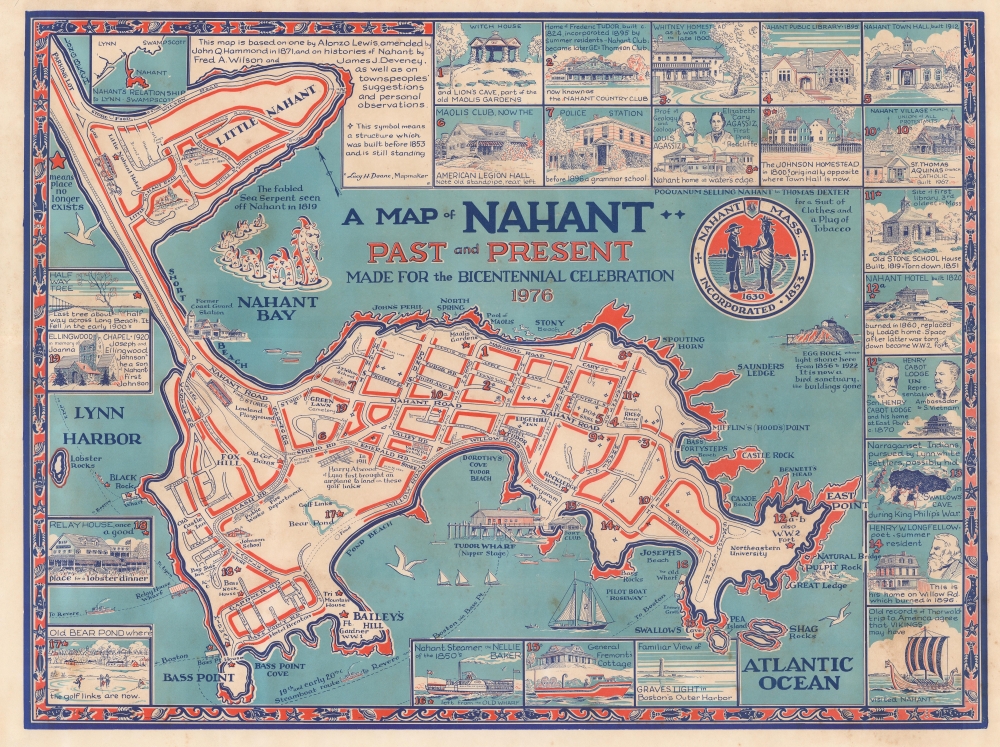
A Map of Nahant, Past and Present Made for the Bicentennial Celebration, 1976.
1976 (dated) 15 x 20 in (38.1 x 50.8 cm) 1 : 8700
1976 (dated) 15 x 20 in (38.1 x 50.8 cm) 1 : 8700
Description
An unrecorded 1976 pictorial historical map of Nahant, Massachusetts by local artist Lucy H. Doane. This rich and striking work provides a comprehensive overview of local history, institutions, and lore.
Coverage includes the full island of Nahant, Little Nahant (which is part of the town), and several nearby rocks and islets. Streets are labeled, as are a wealth of historic homes, government offices, schools (including Northeastern University's Marine Science Center), wharves, beaches, forts, a golf course, and more. Nineteen such sites are noted on the map with a number corresponding to an illustration in the margins. Stars mark the location of places and features that no longer exist. Along with the modern paved road (Nahant Rd.) linking the town with the mainland, a horse and buggy and streetcar (the Nahant and Lynn Streetcar, opened in 1906) are illustrated along the isthmus leading to Lynn. Perhaps the most noticeable feature on the map is a large sea serpent that was spotted by hundreds of locals along the North Shore in 1817 - 1819 (which may have been a group of pilot whales or narwhals swimming in close proximity).
A Closer Look
Nahant is a tied island, meaning an island connected to the mainland by a sandy isthmus called a tombolo. Unsurprisingly, the town's history has been closely connected with the Atlantic Ocean and it was one of the first places on the North Shore settled by the Puritans (in 1630, as seen in the town seal towards top-right). In the 19th century, with the development of direct steamboat connections with Boston, sparsely-inhabited Nahant became a summertime resort for Bostonians, including Louis Agassiz and Henry Wadsworth Longfellow, both illustrated in the margins.Coverage includes the full island of Nahant, Little Nahant (which is part of the town), and several nearby rocks and islets. Streets are labeled, as are a wealth of historic homes, government offices, schools (including Northeastern University's Marine Science Center), wharves, beaches, forts, a golf course, and more. Nineteen such sites are noted on the map with a number corresponding to an illustration in the margins. Stars mark the location of places and features that no longer exist. Along with the modern paved road (Nahant Rd.) linking the town with the mainland, a horse and buggy and streetcar (the Nahant and Lynn Streetcar, opened in 1906) are illustrated along the isthmus leading to Lynn. Perhaps the most noticeable feature on the map is a large sea serpent that was spotted by hundreds of locals along the North Shore in 1817 - 1819 (which may have been a group of pilot whales or narwhals swimming in close proximity).
Publication History and Census
This map was drawn by Lucy H. Doane in 1976. As stated in a note above the title, it is based on an 1829 map by Alonso (or Alonzo) Lewis ('Map of Lynn and Saugus, Settled in 1629') which was then amended by John Hammond, with additional information added from works on local history and from input by townspeople, including Doane herself. The map is not known to exist in any institutional collections (Nahant Historical Society sells postcard-sized reproductions of the map, which may be based on an original in the society's collections) and has no known history on the market.Cartographer
Lucy H. Doane (December 22, 1908 - May 22, 2010) was an artist and teacher based in Nahant, Massachusetts. Born in Nahant, she attended the Lynn Classical School and then the Massachusetts College of Art, where she graduated in 1929. She then received an M.F.A. from the Teachers College at Columbia University in New York City. Doane taught art for several years at Keene Teachers' College in New Hampshire and then become Director of Art in the public schools in Rutland, Vermont. She continued to produce her own work, including illustrations for children's books and landscape paintings based on scenery in Vermont and her native North Shore of Massachusetts. In the late 1990s, she returned to her hometown of Nahant, remaining active in the local arts scene and earning the distinction of being the town's oldest resident. More by this mapmaker...
Condition
Very good. Light foxing.