This item has been sold, but you can get on the Waitlist to be notified if another example becomes available, or purchase a digital scan.
1886 Swain / Ewer Map of Nantucket, Massachusetts w/ The Nantucket Hotel
NantucketHotel-swain-1886$1,375.00

Title
The Nantucket.
1886 (undated) 9 x 14 in (22.86 x 35.56 cm) 1 : 90000
1886 (undated) 9 x 14 in (22.86 x 35.56 cm) 1 : 90000
Description
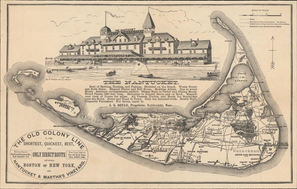
A most unusual c. 1886 variant on the Ewer map of Nantucket, published to jointly promote the opening of 'The Nantucket', the island's first grand hotel, and the Old Colony Line's Nantucket / Martha's Vineyard service.
The map is richly detailed and expressive of Nantucket's topography, road system, railroad lines, and political breakdown. It illustrates swamps, ponds, important hotels, lighthouses, hills, and more. Swain's updates reflect recent changes on the island, including the construction of the Hotel Nantucket, the Nantucket Railroad from the harbor to Surfside and on to Siasconset, and life-saving stations at Coskata and Muskeget Island.
The Nantucket remains in operation.
A Closer Look
The map is derived from an earlier map issued by Ferdinand Cartwright Ewer (1826 - 1883) in 1869, titled Historical Map of Nantucket. Geographically, it conforms with the updates and revisions executed by Joseph B. Swain around 1886, though highly reduced. Swain's large format version of the Ewer was also issued for The Nantucket and today is considered the largest and best map of the island to appear in the 19th century. Although unattributed, it is likely that Swain was behind this smaller map as well.The map is richly detailed and expressive of Nantucket's topography, road system, railroad lines, and political breakdown. It illustrates swamps, ponds, important hotels, lighthouses, hills, and more. Swain's updates reflect recent changes on the island, including the construction of the Hotel Nantucket, the Nantucket Railroad from the harbor to Surfside and on to Siasconset, and life-saving stations at Coskata and Muskeget Island.
The Nantucket
The present map was introduced, likely by J. B. Swain, in or around 1886. It is a promotional piece associated with the Hotel Nantucket, boldly illustrated here and mapped on Brant Point. The Nantucket was the first grand hotel on the island, a response to growing 'summering' interest. We know Swain was a Nantucket hotelier in his final years, so his association with the Hotel Nantucket, while not fully verified, is almost certain. The Nantucket's services are concisely described on this map,Best of Bathing, Boating, and Fishing. Situated on the Beach. Water Frontage Both Sides. Elegant Parlor and Ball Room. Bowling Alleys. Gas in every Room. Sanitary arrangements perfect. Steam Heat and Parlor and Dining Room. Broad Piazza 260 feet long. Balconies in Second Story and on Roof. Magnificent view of Ocean for miles. All Vessels, Yachts, and Boats for Nantucket pass the Hotel. Ferry and Road to Town. Only ten minutes Walk. Newly Built. Elegantly Furnished.The hotel's proprietor is identified as 'J. S. Doyle', referring to Joseph S. Doyle (1827 - 1887), a Nantucket businessman, hotelier, and, until his death, owner of both Ocean House and The Nantucket Hotel. The appearance of his name on this map confirms a print date between the hotel's opening in 1886 and Doyle's death in 1887.
The Nantucket remains in operation.
The Old Colony Railroad
Founded in 1845, the Old Colony Railroad operated in southeastern Massachusetts and parts of Rhode Island until 1893. Named after the 'Old Colony,' a reference to Plymouth, its network grew extensively through mergers and acquisitions. Old Colony operated both passenger and freight services, as well as steamship service to New York City and Boston. A steamer between Woods Hole, Martha's Vineyard, and Nantucket also operated from 1872. The New York, New Haven, and Hartford Railroad acquired the Old Colony trackage rights in 1893 and renamed it the 'Old Colony Division' of the New York, New Haven, and Hartford Railroad. Portions of the railroad's network have been incorporated into the MBTA Commuter Rail system, namely, the Middleborough/Lakeville and Kingston/Plymouth Lines. They are known informally as the 'Old Colony Lines.'Publication History and Census
This map was designed and printed c. 1886 for The Nantucket Hotel. It reflects the original survey work of Ferdinand Cartwright Ewer with updates likely by Joseph B. Swain. There are many variants of this map, most titled Historical Map of Nantucket, used extensively by the Old Colony Line to promote their services. This is the only example we have identified that features the impressive illustration of The Nantucket Hotel. This is also the only example of this map known to survive.CartographerS
Ferdinand Cartwright Ewer (1826 - 1883) was born on May 22nd of 1926 in town of Nantucket on the Massachusetts island of the same name. Ewer's father, a prominent Nantucket businessman, moved his family to Providence Rhode Island when Ferdinand was three and then, further afield, to New York City. It was not until his 13th year that Ewer returned to Nantucket where he would remain until 1844 when was matriculated at Harvard. There he grew intellectually and strayed from his religiously ideological upbringing, embracing atheism. Shortly following his graduation in 1848, Ewer, like many others, was drawn westward by the lure of the California Gold Rush. "I have no gold fever," he says pathetically in his diary, "I only desire not to starve." In San Francisco he worked as a clerk in the claims office and later as newspaper reporter with The Alta Californian. In a tale typical of the Wild West, a bar room conversation in a mining town inspired Ewer to change his life, abandon his atheism, and became a Reverend of the Episcopal Church. As Reverend, Ewer generated a popular following in San Francisco. Nonetheless, in time he decided to move back to the east coast and, eventually, became the rector of New York City's Christ's Church. A highly educated man, Ferdinand devoted much of his intellectual energy in reconciling the positions of science with religion. To the chagrin of his Episcopalian superiors, Ewer believed that the premises of Darwinism, astronomy, and medicine were in fact compatible his faith. Eventually, Ewer's scientific leanings drove him from the Christ Church, at which point he established the New York church of St. Ignatius of Antioch, where he remained to his death in 1883. It was sometime during his tenure in New York that Ewer composed his famous map of Nantucket. More by this mapmaker...
Joseph B. Swain (December 31, 1814 - June 17, 1888) was a Nantucket tinsmith, businessman, and insurance agent based in Nantucket, Massachusetts in the middle part of the 19th century. Swain was born and lived most of his life in Nantucket, where he had an insurance business. Later in his life, recognizing Nantucket's allure for tourists, he constructed and managed a hotel, almost certainly the Hotel Nantucket, constructed on Brant Point in 1884. Most likely, promotion of his hotel was what prompted Swain to engage in his only cartographic endeavor, the production of a large sale reissue of Ferdinand Cartwright Ewer's iconic 1869 map of Nantucket. Swain was a teetotaler and a 'birthright member of the Society of Friends.' He died after a brief illness at 73. Learn More...
Condition
Very good. Laid down on archival tissue. A few minor edge splits, stabilized.