
1900 Walker Bird's-Eye View and Map of Narragansett Bay, Massachusetts

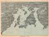
Narragansett Bay.
Narragansett Bay - including Providence!
- Digital Map Information
- Suitable for large format printing
- Full resolution TIFF file
- ICC color profile embedded
- Delivered instantly via download link
Narragansett Bay - including Providence!
This is an uncommon c. 1900 George H. Walker bird's-eye view map of Narragansett Bay, Rhode Island. This is one of a series of view and maps published by Walker, among others, to serve the on-board and in-terminal newsstand market. The views were sold as souvenirs as well as practical guides to the journey.A Closer Look
The view depicts the entirety of Narragansett Bay, from Point Judith to Providence, and extends eastward as far as Warren Point and Sakonnet. It identifies Newport, Conanicut Island, Prudence Island, Rhode Island, and various settlements along the bay's shoreline. Ferry routes crisscross the bay and lighthouses are illustrated in profile. Railroads appear as well, including the New York, New Haven, and Hartford Railroad.Publication History and Census
This map was produced by Boston map publisher George H. Walker and published c. 1900 by the Rhode Island News Co. of Providence, Rhode Island. Walker is better known for his similar view maps of Boston Harbor - the present example is thus somewhat out of his focus area and very scarce. We note five examples cataloged in OCLC which are part of the collections at the New York Public Library, Brown University, Harvard University, the State Library of Massachusetts, and the University of California Santa Barbara.Cartographer
George Hiram Walker (January 4, 1852 - November 14, 1927) was a Boston based publisher of books, views, and maps active in the late 19th and early 20th centuries. Born in Springfield, Vermont, Walker started his life as a dry goods merchant but developed an active interest in publishing during the early 1870s. Walker began publishing in 1878 when he partnered with an unknown New York Firm. Two years later, Walker brought the operation in house by partnering with his brother, Oscar W. Walker, in the opening of a lithography studio at 81 Milk Street, Boston. Shortly thereafter the firm expanded to new offices at 160 Tremont Street, Boston. The Walker brothers produced a large corpus of works, most of which focused on travel and tourism in New England. Walker also established the Walker-Gordon Milk Laboratory with Dr. Thomas Morgan Rotch and Gustave Gordon. This interesting investment was based on the premise that infant deaths could be avoided by providing higher quality milk. The company eventually became a great success, producing a high-quality cow milk that closely resembled human breast milk. In the process the Walker-Gordon laboratory developed many of the dairy health standards that are still with us today. Walker married Irene L. Loud on March 25, 1885. Further Details...
Condition
Good. Light wear along original fold lines. Areas of infill in top and bottom margin. Slight area of infill along top border. Light toning and soiling.
References
OCLC 36488389.