This item has been sold, but you can get on the Waitlist to be notified if another example becomes available, or purchase a digital scan.
1944 Navy Education Services Map of World War II as a Global War
NavWarMap6-navy-1944$450.00

Title
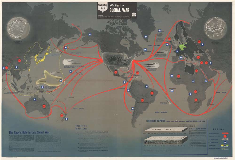
NavWarMap No.6. We Fight a Global War.
1944 (dated) 38.75 x 58.5 in (98.425 x 148.59 cm) 1 : 42240000
1944 (dated) 38.75 x 58.5 in (98.425 x 148.59 cm) 1 : 42240000
Description
This is a 1944 Navy Education Services map of World War II as a global war. NavWarMap No. 6, tracing the global reach of the U. S. Navy, is the only world map in the NavWarMap series. Red arrows highlight American supply lines throughout the world. White stars inscribed in blue squares mark where American armed forces are active, including northern France, hinting that this map was published after the June 6, 1944, D-Day landings in Normandy. Other illustrations highlight American naval might, and promote the Navy's many successes in keeping the enemy from U.S. shores.
A Global War of Logistics
An often overlooked aspect of the war is the herculean task of supplying millions of soldiers throughout the world. As stated in the text in the bottom left, U.S. supply lines stretched 56,000 miles, or more than twice the circumference of the Earth. The supplies needed to sustain a single soldier was measured in tons of cargo per man per month. It was essential that supplies arrive safely and on time, and supply lines often an easy target. The need to protect supply line convoys only compounded the logistic challenge.Supply Depot to the World
As one of the few industrialized nations not devastated, the United States became the de facto supply depot for the entire Allied war effort. American industry was unaffected by the fighting and continued to increase output throughout the war. This allowed the United States to support Allies through the Lend-Lease System. A graphic situated in the lower right details in broad terms where these supplies were sent and what kinds of supplies were provided.The NavWarMap Series
The NavWarMap series is a series of six maps created by the Bureau of Naval Personnel, part of the Navy Department, and distributed by the Educational Services Section of the Bureau of Naval Personnel. The duties and mission of the Educational Services Section is unclear, but we believe these maps were created to educate and train naval and marine personnel. The Navy believed well-educated men became more effective sailors and marines. These maps were printed in both single- and double-sided versions. We have been unable to ascertain why both versions were printed. The full sequence includes:- NavWarMap No. 1 - The Mediterranean
- NavWarMap No. 2 - The South China Sea Area
- NavWarMap No. 3 - World War II in the North Sea Area
- NavWarMap No. 4 - The North Pacific Area
- NavWarMap No. 5 - Southwest Pacific
- NavWarMap No. 6 - We Fight a Global War
Publication History and Census
These maps were created by the Bureau of Naval Personnel, most likely by the training division, and distributed by the Educational Services Section. The maps of the NavWarMap series were created both to inform and motivate Allied soldiers, sailors, and airmen. No OCLC references exist for the individual maps. One OCLC entry catalogues nine institutions that possess the entire set: Franklin and Marshall College, the Ohio State University, the University of Michigan, the University of Wisconsin, the Wisconsin Historical Society, the University of Florida, Idaho State University, the National Library of Australia, and Monash University in Clayton, Australia. NavWar Map No. 6 as an individual piece is not cataloged in OCLC, but it is part of the David Rumsey Map Collection.Condition
Good. Exhibits wear along original fold lines. Three small areas of infill at fold intersections. Closed margin tears professionally repaired on verso. Closed tear extending one inch in lower Pacific Ocean not effecting any text professionally repaired on verso. Exhibits light soiling.
References
Rumsey 8760.006.