This item has been sold, but you can get on the Waitlist to be notified if another example becomes available, or purchase a digital scan.
1860 Johnson Map of Nebraska Territory and Kansas
NebraskaKansas-johnson-1860$275.00

Title
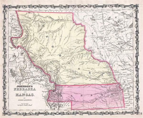
Johnson's Nebraska and Kansas.
1860 (undated) 13.25 x 16 in (33.655 x 40.64 cm) 1 : 4942080
1860 (undated) 13.25 x 16 in (33.655 x 40.64 cm) 1 : 4942080
Description
A beautiful 1860 first edition example of Johnson's map of Nebraska and Kansas. This is one of the rarest and most desirable of all Johnson atlas maps. Like most of Johnson's state maps, this map was derived from the work of J. H. Colton, who derived his atlas maps from an earlier wall map of North America produced by Colton and D. Griffing Johnson. The map details the regions between the Great Salt Lake and Iowa and between the Canadian Border and New Mexico, covering territorial Kansas and Nebraska as well as parts of adjacent Minnesota, Iowa, Missouri and Utah.
This map is hand colored in pink, green, yellow and blue pastels to define state and territorial boundaries. Surrounded by Johnson's typical strapwork border used from 1860 to 1864. Issued for the 1860 first edition of Johnson's Family Atlas.
Nebraska Territory at its Fullest
This is one of the few maps to focus in the vast and ephemeral Nebraska in its full territorial glory extending from the 40th parallel to the border British America or Canada. This massive Nebraska territory, incorporated in May of 1854, included most of the northern Great Plains, much of the Missouri River Basin, and the eastern part of the northern Rocky Mountains. By 1861, a year after this map appeared, Nebraska Territory would be significantly reduced by the formations of Colorado and Dakota Territories.American Indian Lands
When this map was printed Nebraska and Kansas had only recently been opened for settlement. Consequently, it excited considerable interest as both a place of resettlement and a dangerous segment of the transcontinental emigrant routes. At the time, this area was populated by diverse and powerful Indian nations including the Comanche, Kioways, Arapahoes, Cheyennes, Sioux, Dacotahs, Poncas, Pawnee's, Omahas, Missouris, Delawares, Shawnee, Osages, Crow, Black, and others - whose territorial claims Johnson attempts to note.Proposed Pacific Railroad Routes
Johnson also identifies three of the routes proposed for the Pacific Railroad, the Stevens Route far to the north, the Beswith Route running through the center of the map, and the Gunnison Route passing through Kansas. Settlement of this region would soon lead to the discovery of gold around Pike's Peak and the 1858-1859 Colorado Gold Rush.This map is hand colored in pink, green, yellow and blue pastels to define state and territorial boundaries. Surrounded by Johnson's typical strapwork border used from 1860 to 1864. Issued for the 1860 first edition of Johnson's Family Atlas.
Cartographer
Alvin Jewett Johnson (September 23, 1827 - April 22, 1884) was a prolific American map publisher active from 1856 to the mid-1880s. Johnson was born into a poor family in Wallingford, Vermont, where he received only a basic public education. He is known to have worked as a school teacher for several years before moving to Richmond, Virginia. Johnson got his first taste of the map business as a salesman and book canvasser for J. H. Colton. The earliest Johnson maps were published with D. Griffing Johnson (no clear relation) and date to the mid-1850s; however, it was not until 1860 that the Johnson firm published its first significant work, the Johnson's New Illustrated (Steel Plate) Family Atlas. The publication of the Family Atlas followed a somewhat mysterious 1859 deal with the well-established but financially strapped J. H. Colton cartographic publishing firm. Although map historian Water Ristow speculates that Colton sold his copyrights to Johnson and his business partner, another Vermonter named Ross C. Browning (1822 - 1899), a more likely theory is that Johnson and Browning financially supported the Colton firm in exchange for the right to use Colton's existing copyrighted map plates. Regardless of which scenario actually occurred, it is indisputable that the first Johnson atlas maps were essentially reissues of earlier Colton maps. Early on, Johnson described his firm as the 'Successors to J. H. Colton and Company'. Johnson's business strategy involved transferring the original Colton steel plate engravings to cheaper lithographic stones, allowing his firm to produce more maps at a lower price point. In 1861, following the outbreak of the American Civil War (1861 - 1865) Johnson and Browning split their firm between two offices. Johnson moved from Richmond, Virginia, to New York City. Browning remained in Richmond, where he published at least one more edition of the atlas in 1862, at the height of the war. Johnson and Browning published two editions of the Johnson Atlas: 1860 (Richmond and New York) and 1861 (Richmond and New York). Sometime in 1861, Browning's portion of the firm (or perhaps the New York portion?) was purchased by Benjamin P. Ward, whose name subsequently replaced Browning's on the imprint. The 1863 issue of the Family Atlas was one of the most unusual, it being a compilation of older 'Johnson and Browning' maps, updated 1862 'Johnson and Ward' maps, and newer 1863 maps with a revised border design. The 1864 issue of the Family Atlas is the first fully 'Johnson and Ward' atlas. Johnson published one more edition of the atlas in partnership with Ward in 1865, after which Johnson bought out Ward. The next issue of the atlas, 1866, is the first purely 'Johnson' atlas with all new map plates, updated imprints, and copyrights. The Family Atlas went through roughly 27 years of publication, from 1860 to 1887, outliving Johnson himself, who died in 1884. Johnson maps from the Family Atlas are notable for their unique borders, of which there are four different designs, the 'strapwork border' from 1860 to 1863, the 'fretwork border' from 1863 to 1869, the 'spirograph border' in 1870 to 1882, and a more elaborate version of the same from 1880 to 1887. In addition to the Family Atlas, Johnson issued numerous wall maps, pocket maps, and in the 1880s, the Cyclopedia. Johnson maps are known for their size, accuracy, detail, and stunning, vivid hand coloring. Johnson's maps, purely American in their style and execution, chronicle some of the most important periods in American history, including the Civil War, the Westward Expansion, and the Indian Wars. Today Johnson's maps, especially those of the American West, are highly sought after by map collectors and historians. More by this mapmaker...
Condition
Very good. Even overall toning Blank on verso.
References
Rumsey 2905.028.