1845 Meyer Map of Arkansas
NeuesteKarteArkansas-meyer-1845$125.00

Title
Neueste Karte von Arkansas mit seinen Canaelen Strassen und Entfernungen der Hauptpunkte.
1845 (dated) 15.25 x 12.25 in (38.735 x 31.115 cm) 1 : 1700000
1845 (dated) 15.25 x 12.25 in (38.735 x 31.115 cm) 1 : 1700000
Description
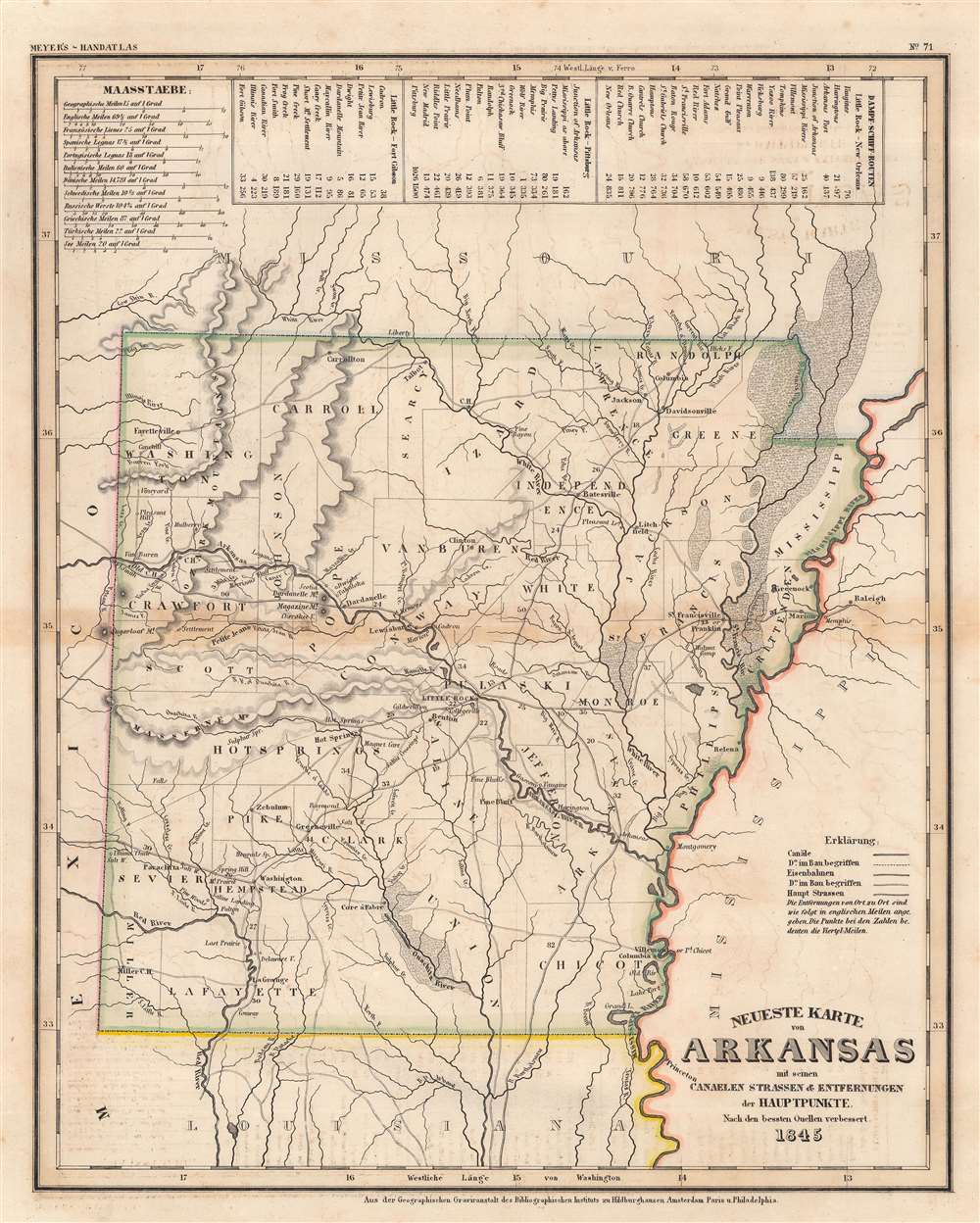
This is an 1845 Joseph Meyer map of Arkansas. The state's road, railroad, and canal network is illustrated in detail, with railroads and canals under construction depicted. Dotted lines separate counties. Cities, towns, and villages are labeled. Indian villages are marked as well, with a Delaware Village appearing just above La Grange. Arkansas's river system is detailed as well, with the Arkansas, Mississippi, and Red rivers all illustrated, along with numerous creeks and streams. Three distance tables situated along the top border provide itineraries and distances from Little Rock to New Orleans, Pittsburg, and Fort Gibson.
Publication History and Census
This map was created for and published by Joseph Meyer in the 1845 edition of his Handatlas. We note four examples of the separate map cataloged in OCLC which are part of the collection at the University of Michigan, the University of Arkansas - Fayetteville, Landesbibliothekszentrum Reinland-Pfalz in Speyer, Germany, and the Universitätsbibliothek Eichstätt-Ingolstadt in Eichstätt, Germany.Cartographer
Joseph Meyer (May 9, 1796 - June 27, 1856) was a German industrialist, merchant, and publisher, active in Germany in the early to mid 19th century. He is best known for publishing the encyclopedia Meyers Conversation-Lexicon. Born in Gotha, Germany, Meyer was educated as a merchant in Frankfurt am Main. He moved to London in 1816, but returned to Germany in 1820 after his stock speculations and business adventures fell through. Once back in Germany, he began by investing in the textile trade (1820 - 24). Meyer began creating business plans concerning how to start railways soon after the first steam-hauled railway began operation in December 1835. He founded the Deutsche Eisenbahnschienen-Compangie auf Actien (German Railway Rail joint stock company) in 1845. Meyer also found great success as a publisher, utilizing the system of serial subscriptions to publications, a new idea for the time. He founded a company, Bibliographisches Institut in Gotha in 1825, which published several versions of the Bible, works of classical literature, atlases, the world in pictures on steel engravings, and an encyclopedia. He moved the Institut from Gotha to Hildburghausen in 1828. He published several atlases, including Meyer's Groẞer Hand-Atlas (1843 - 1860). In 1848, he supported the Springtime of the Peoples Revolutions that took place throughout Germany and much of Europe. When the revolutions failed in 1849, Meyer was briefly imprisoned for his support of revolutionary activities. The revolutions also began to take a toll on Meyer's business interests, and when he died, in 1856, the Bibliographisches Institut was struggling financially. His son, Herrmann Julius Meyer, took over the firm, spearheading a rapid recovery. This, and other businesses prospered under Herrmann Julius (April 4, 1826 - March 12, 1909) and when he died in 1909, he led the richest family in Saxony, with more total wealth than the King of Saxony More by this mapmaker...
Condition
Good. Toning along original centerfold. Light foxing.
References
OCLC 632916450, 878506356.