1948 Pictorial Tourist Map of Arizona, Nevada, and Utah Printed on a Napkin
NevadaUtah-bestops-1948-2$250.00

Title
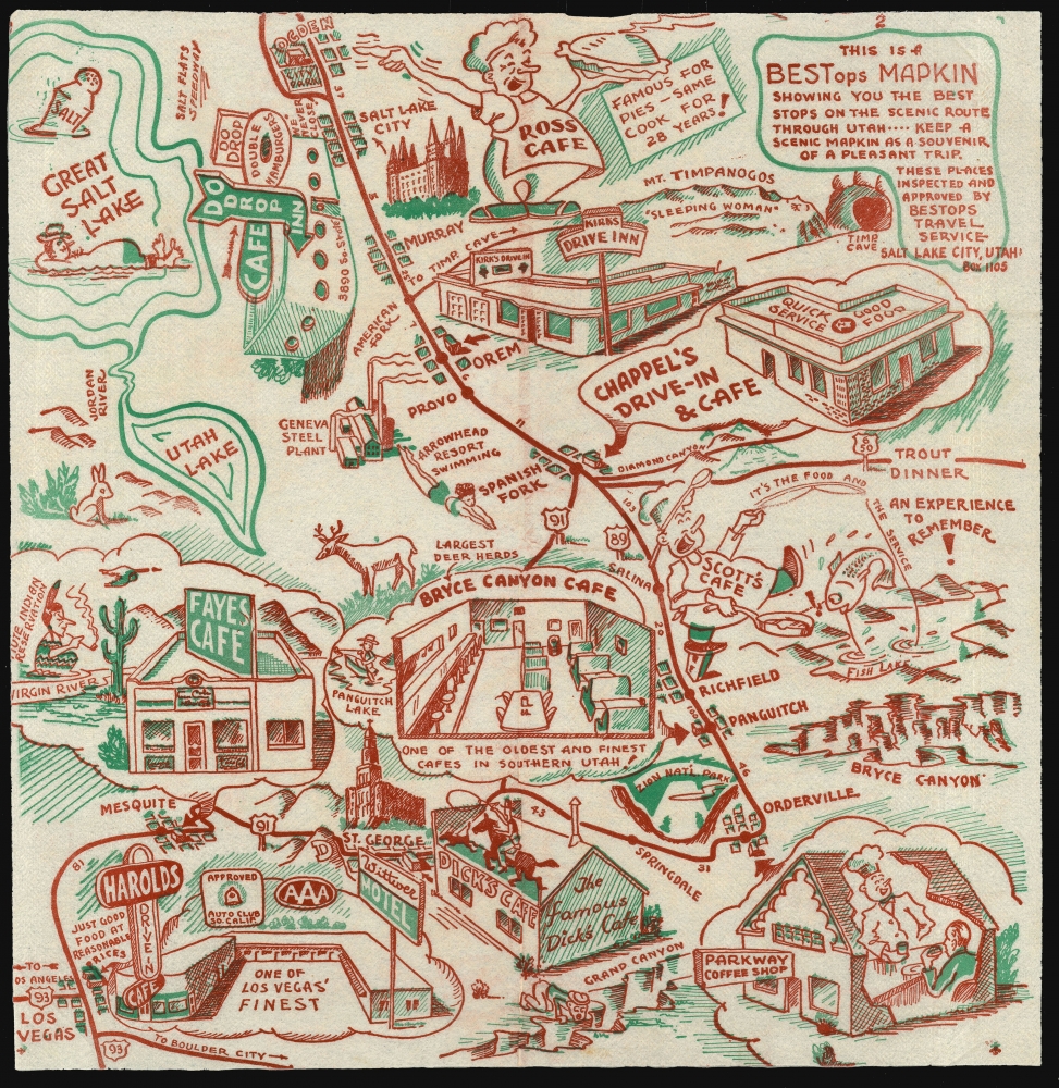
This Is A BESTops MAPKIN Showing you the best stops on the scenic route through Utah ---- keep a scenic Mapkin as a souvenir of a pleasant trip. These Places inspected and approved by BEStops Travel Service Box Salt Lake City Utah. Box 1105.
1948 (undated) 13.25 x 13 in (33.655 x 33.02 cm)
1948 (undated) 13.25 x 13 in (33.655 x 33.02 cm)
Description
A rare survival: a 1948 map of parts of Arizona, Utah and Nevada, printed in two colors on a diner napkin. This 'Mapkin' represents a pictorial icon of the pre-interstate road trip, focusing specifically on the region from Las Vegas (here misspelled 'Los Vegas') and the Grand Canyon in the south, to the Great Salt Lake, Salt Lake City, and Mount Timpanogos in the north. The region's natural monuments were the draw for postwar tourists, but the primary focus of this map is on the area's restauranteurs. Throughout are interspersed a charming array of iconic travelers' destinations: historical sites and monuments, natural landmarks, and recommendable eateries to support the hungry tourists en route between.
Pre-Interstate Highways
The map marks attractions along the main highways, prior to the development of the interstate system which would bypass these towns altogether. These included Route 93 (connecting Las Vegas with Boulder City and points south), but the main focus here are locations along Route 91 between Las Vegas and Ogden, and Route 89 from Orderville to Spanish Fork. Also marked is the Old Utah Highway 6 and 50, which formerly led to Grand Junction, Colorado and was replaced by Interstate 70. Connecting Orderville and St. George is an unnamed route consistent with Utah State Highway 9, now the Zion Park Scenic Byway.Before the Dawning of a Chicken Dynasty
Pictured in Salt Lake City is the 'Do Drop Inn Cafe,' advertising double hamburgers, and the boast 'We Never Close.' The tiny, eight booth restaurant was run by Pete and Arline Harman, who would replace the building with a larger structure in 1951, re-naming it 'Harman's Cafe.' A fateful meeting that year with North Carolinian Harland Sanders would lead to a franchise deal, and in 1952 the cafe would be re-named 'Kentucky Fried Chicken,' the first restaurant of that global brand.Roadside Restauranteurs
Few of the establishments memorialized here would have so illustrious a fate. Most are gone, even the Bryce Canyon Cafe, 'one of the oldest and finest cafes in southern Utah' according to the map. Ross Cafe in Ogden 'Famous for Pies - same cook for 28 years!' was in some respects a newcomer on the map. Dating back as far as the mid-twenties, the Cafe was known as 'Ross and Jack Cafe,' but a falling out between the owners led to the physical partitioning of the restaurant into two separate establishments in 1947.The Business At Hand
The 'mapkin' was intended as an advertising work, not a nostalgia piece, so consequently the businesses named on it were ones that were in operation at the time. Therefore, despite the piece's lack of a date, we can make an estimation based on its content. 'Do Drop Inn' wouldn't change to 'Harman's Cafe' until 1951. 'Ross Cafe' having split from 'Jack Cafe' in 1947, a date much earlier than this appears unlikely, but we do not see newspaper advertisements for the cafe after 1948, which encourages us with respect to an early date of that year for this piece.Natural Wonders
The Grand Canyon marks the southern border of the map, but it is not the only natural wonder depicted here. Zion National Park, Bryce Canyon, and Mount Timpanogos (and its famous Cave) are all marked. Fish Lake, Panguitch Lake, Utah Lake, and Great Salt Lake (with a floating tourist and a giant diner salt shaker) are also illustrated. Other locations of note - the Geneva Steel Plant, Arrowhead Resort, and the Piute Reservation are illustrated as well.Publication History and Census
This mapkin was produced by the BESTops Travel Service of Salt Lake City, Utah; it is an early example of the company's work, numbered '2;' we are aware of an example numbered 143. Apart from the November 9, 1973 notice in the Salt Lake Times of the business' suspension by the Utah State Tax Commission, we are unable to find any evidence of this firm beyond its output, which primarily focused on the American Southwest. Only one of these, focusing on New Mexico attractions, is listed in OCLC in a solitary example. Given the purpose and general life expectancy of the diner napkin, as a form, the scarcity of these objects is perhaps unsurprising.Cartographer
BestOPS (fl. 1948-1952), a.k.a. Best Stops Travel Service, was an American map-centered advertising company that arrived, and vanished, in the period following World War II (1939 - 1945) but preceding the c. 1955 explosion of the Interstate Highway System. The company's sole apparent product was a series of maps printed on diner napkins - hence, Mapkins - intended to promote roadside restaurants and cafes along the scenic routes to America's national parks and wonders. Thus the mapkins capture the moment in American automotive history in which newly prosperous families took to the roads and ate their way across America, one diner at a time.
The company's address - always printed on the Mapkin - appears briefly to have been in Portland, Oregon but then to have relocated to Utah. A few show an address in Provo, but the majority we have identified show one of several addresses in Salt Lake City; after 1951, mainly in the Beason Building. Most of the Mapkins can be dated, with reasonable confidence, based on the rapidly-changing landscape of the restaurant trade. Our research suggests that most were printed between 1948 and 1952.
The Salt Lake City directories of 1951 and 1952 are illuminating. The '51 directory includes an entry for BestOPS Travel Service, naming a Dorius E. Black as manager. In 1952, the directory names instead 'Best Stops Travel Service;' Black is listed as Vice President and Sales Manager, with its president listed as Lincoln C. White. Lincoln Carter White (1919 - 1986) was a successful Salt Lake City jeweler, who had offices in the Beason Building that correspond to the address found on Mapkins after 1951. We suspect White not to have been the creator of the Mapkins, but an investor.
Dorius Ether Black (March 15, 1918 - June 29, 1985) is a better candidate. Before his wartime service in the navy reserves, he had travelled abroad as a missionary. We see no indication of his profession between 1946 and 1950; The 1950 Census listed him as separated, and living in Provo with his mother and siblings. His profession was listed as a salesman with 'Travel Service,' with two younger sisters working as stenographers for the same. Up until 1951, BestOPS Travel Service operated via post office box addresses, in Provo, Salt Lake City, and briefly in Portland, Oregon. We suspect that Black started BestOPS and ran it out of his mother's house, with the assistance of his sisters, while he travelled around the country selling his mapkins to various diners en route. As a LDS missionary, he may well have been traveling as a proselytizer at the same time. In 1951 or 1952, he sold the business, or a share of it, to White: perhaps with an eye to providing a home for his fiancee, whom he would marry in 1952. White's involvement brought changes: more industrial printing methods, slicker branding, and a less-confusing business name - while as Vice President and Sales Manager, Black continued to travel and work his sales contacts. But before long, his travels for Best Stops brought him to Florida, and he decided to stay there - first in St. Petersburg, where he would begin work for a brokerage, and then to Orlando. Without Black, Best Stops appears to have ceased producing new Mapkins. White seems to have kept the business until it was struck from the Utah tax rolls in November 9, 1973, but while it appears likely that Best Stops would have continued trying to sell its back stock, we have seen no Mapkin that could credibly have been made any later than 1952 or 53.
We would like to extend our gratitude to Doug Misner, Library and Collections Manager of the Utah Historical Society, for his crucial assistance in identifying the individuals behind these fascinating pieces of cartographic Americana. More by this mapmaker...
Condition
Very good. Original folds present. No soup.
References
Not in OCLC.