1901 Temple Map of Nome and Vicinity, Copper River Region, Alaska
NewAlaskaGoldfields-temple-1901$2,000.00

Title
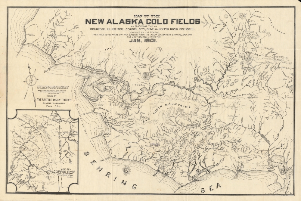
New Alaska Gold Fields showing the Kougrock, Bluestone, Council City, Nome and Copper River Districts.
1901 (dated) 22.75 x 34.25 in (57.785 x 86.995 cm) 1 : 555000
1901 (dated) 22.75 x 34.25 in (57.785 x 86.995 cm) 1 : 555000
Description
A rare and informative map of the 'new' Alaska gold rushes that followed the Klondike Gold Rush, focusing on the area around Nome on the Seward Peninsula and the Copper River. It was drawn by John Gordon Temple, printed by C. E. (or C. F.) Oliver, and issued in January 1901 by the Seattle Daily Times.
The 'government barracks' near Nome was Fort Davis, established by the U.S. Army in 1900 to try to manage the chaos and violence set off by the gold rush. At bottom-left is an inset map of the Copper River region, some 700 miles from Nome but similar in offering opportunities as a 'new' gold field to replace the exhausted Klondike.
Further to the northwest is an 'Indian village,' now the town of Wales, the westernmost city on the North American mainland, less than 70 miles from the Russian shoreline of Chukotka Autonomous Okrug. The area had been home to an indigenous settlement for centuries, known as Kingaghee or Kingigin around the time of contact with Russians and Americans. The site was suitable due to its proximity to migration routes for whales and other sea creatures through the narrowest part of the Bering Strait. Today the town is a Native Village governed by a tribal council.
This map relates to a gold rush centered on the 'new' Alaska gold fields in the southern part of the Seward Peninsula around Nome, which was set off by the discovery of gold in the region in September 1898. With the Klondike already inundated with diggers by 1898, new sources of the precious metal were sought in Alaska's wilderness. News of the abundance of gold around Nome - it often lie on the beach in abundance without the need for a claim - spread quickly and caused great excitement. Thousands of miners left Dawson City (visible in the top-right corner of the inset map at bottom-left), the overnight mining boom town established in the Klondike, and from elsewhere in Alaska and Canada, to descend on the region seen here. The effect was so profound that the gold rush around Nome effectively ended the Klondike Gold Rush by shifting it to the west and north.
However, the easily accessible gold around Nome was quickly snapped up, and even the discovery of new deposits could not halt the inevitable decline in the gold. In 1902, gold was discovered near Fairbanks and a new gold rush began, shifting attention deep into the interior. Nome's population, as high as 20,000 at one point, was barely one-tenth of that number by 1910 and had shrunk below 1,000 by 1920.
Another gold rush around the Copper River is the focus of the inset map at bottom-left. The presence of Indian villages on this map hints at the prominent and continued indigenous presence. White settlers first set up in this region as a stopover point for prospectors on their way to the Klondike. But these prospectors began to search the local area as well and by 1900 had found gold along local riverbeds. The inevitable tidal wave of miners arrived, setting up new towns nearly overnight, especially Copper Center. The miner population waxed and waned in the following years as deposits were exhausted and new placers periodically discovered. The area also saw coal and oil booms in the first decade of the 20th century.
A Closer Look
The main map covers the southern part of the Seward Peninsula, with Nome, Teller, and other nearby cities noted. All these towns grew quickly in the months preceding this map's publication and shrank drastically as the gold rush wound down; most became ghost towns. Rivers, streams, lakes, and coastal inlets are drawn and labeled in remarkable detail, no doubt as they were the best places to look for gold, with hills and mountains, terrain, trails, and other features carefully traced. The English names of rivers and creeks, such as Eldorado, Bonanza, Lucky, and several named Gold, reflect the aspirations of the new arrivals.The 'government barracks' near Nome was Fort Davis, established by the U.S. Army in 1900 to try to manage the chaos and violence set off by the gold rush. At bottom-left is an inset map of the Copper River region, some 700 miles from Nome but similar in offering opportunities as a 'new' gold field to replace the exhausted Klondike.
Further to the northwest is an 'Indian village,' now the town of Wales, the westernmost city on the North American mainland, less than 70 miles from the Russian shoreline of Chukotka Autonomous Okrug. The area had been home to an indigenous settlement for centuries, known as Kingaghee or Kingigin around the time of contact with Russians and Americans. The site was suitable due to its proximity to migration routes for whales and other sea creatures through the narrowest part of the Bering Strait. Today the town is a Native Village governed by a tribal council.
Reindeer Preserve
A reindeer reserve appears near Teller across Port Clarence Harbor. Though often associated with the region, the animals are not native, and this preserve at Port Clarence was the first place they were introduced to Alaska. The U.S. government (led by missionary Indian agent Sheldon Jackson) believed the reindeer could provide a means of sustenance for indigenous communities aside from seals, whales, and walruses. In 1893, the Alaska Reindeer Service was established with the aim of importing reindeer from nearby Siberia. Rather bizarrely, Sami people from Finland were also recruited to teach the local Iñupiat how to hunt reindeer.Gold Rushes in Alaska
Gold was first discovered near the mouth of the Klondike River in August 1816 by a party of Tagish American Indians. The original Yukon Gold Discovery was made in 1896 in the Bonanza (Rabbit) Creek area, but it quickly became apparent that the gold deposits were far vaster. Word traveled quickly and by July 1897 a stampede of prospectors from throughout the United States and Canada were headed to the Klondike. This was compounded by the fact that a series of bank failures in 1897 left the American economy in disarray and many out of work. Over 40,000 prospectors and their families moved to Alaska, generally by way of Seattle or San Francisco. The Klondike Gold Rush drew such notables as future U.S. President William H. Taft, adventurer Frederick Russell Burnham, and author W. W. White.This map relates to a gold rush centered on the 'new' Alaska gold fields in the southern part of the Seward Peninsula around Nome, which was set off by the discovery of gold in the region in September 1898. With the Klondike already inundated with diggers by 1898, new sources of the precious metal were sought in Alaska's wilderness. News of the abundance of gold around Nome - it often lie on the beach in abundance without the need for a claim - spread quickly and caused great excitement. Thousands of miners left Dawson City (visible in the top-right corner of the inset map at bottom-left), the overnight mining boom town established in the Klondike, and from elsewhere in Alaska and Canada, to descend on the region seen here. The effect was so profound that the gold rush around Nome effectively ended the Klondike Gold Rush by shifting it to the west and north.
However, the easily accessible gold around Nome was quickly snapped up, and even the discovery of new deposits could not halt the inevitable decline in the gold. In 1902, gold was discovered near Fairbanks and a new gold rush began, shifting attention deep into the interior. Nome's population, as high as 20,000 at one point, was barely one-tenth of that number by 1910 and had shrunk below 1,000 by 1920.
Another gold rush around the Copper River is the focus of the inset map at bottom-left. The presence of Indian villages on this map hints at the prominent and continued indigenous presence. White settlers first set up in this region as a stopover point for prospectors on their way to the Klondike. But these prospectors began to search the local area as well and by 1900 had found gold along local riverbeds. The inevitable tidal wave of miners arrived, setting up new towns nearly overnight, especially Copper Center. The miner population waxed and waned in the following years as deposits were exhausted and new placers periodically discovered. The area also saw coal and oil booms in the first decade of the 20th century.
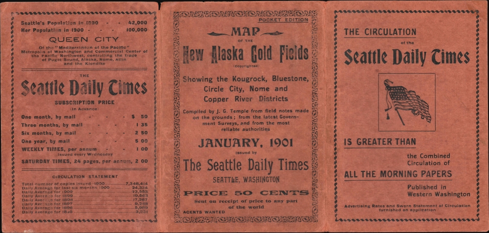
Publication History and Census
This map was drawn by John Gordon Temple, printed by C. E. (or perhaps C. F.) Oliver, and issued in January 1901 for the Seattle Daily Times. Little information is available about either individual. Temple appears to have lived in Portland, Oregon, though the reference to 'field notes' in the title suggests time spent in Alaska. One 'C. E. Oliver' worked as a secretary for mining companies in the Pacific Northwest and Alaska in the following decades, which may be the same individual listed here. This map is especially rare; it is not listed in the standard reference works on maps of Alaska in this era, and the only other known example is held by the David Rumsey Historical Map Collection (the same example is also noted among the holdings of Stanford University).Condition
Very good. Archival verso reinforcement at some old fold intersections. Accompanies original binder.
References
Rumsey 5186.001. OCLC 953571311.