1825 Tanner Map of New England
NewEngland-tanner-1825$1,200.00

Title
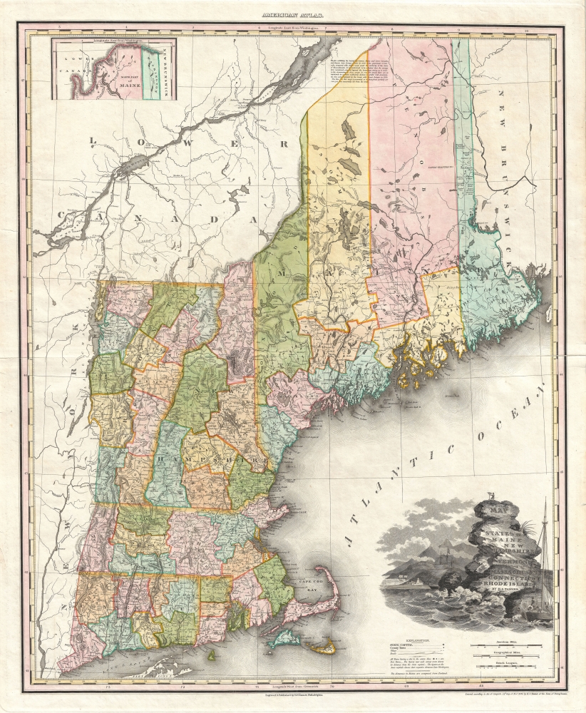
Map of the States of Maine New Hampshire Vermont Massachusetts Connecticut and Rhode Island.
1825 (dated) 27 x 22 in (68.58 x 55.88 cm) 1 : 900000
1825 (dated) 27 x 22 in (68.58 x 55.88 cm) 1 : 900000
Description
This is an 1825 Henry S. Tanner map of New England. This map, like others from Tanner's New American Atlas, is considered an apex achievement of the 'Golden Age of American Map Publishing.' It features an intriguing early Maine county configuration.
A Closer Look
The map depicts the states of Connecticut, Massachusetts, Rhode Island, Maine, Vermont, and New Hampshire. It is most interesting in Maine, where it exhibits a primitive county structure. There is a stunning decorative vignette in the lower right containing the map's title, as well as an illustration of a surveyor on top of a rocky outcrop. In the foreground, fishermen work the cod fisheries while, in the background, a large sailing vessel is being repaired.Publication History
This map was originally engraved for Tanner's New American Atlas, issued between 1819 and 1823. The present example is from the revised edition of the atlas published in 1825. The New American Atlas is considered the apex achievement the 'Golden Age of American Map Publishing.' Each map from the New American Atlas is a finely engraved masterpiece featuring the most up-to-date cartographic information, elaborate thematic cartouche work, and delicate colorwork. All maps from this series are highly desirable and have become extremely scarce - the present example being no exception.Cartographer
Henry Schenck Tanner (1786 - May 18, 1858) was one of the preeminent American map engravers and publishers of the early 19th century - what is considered to be the "Golden Age of American Map Publishing". Born in New York City but based in Philadelphia, Tanner's forty plus year career was almost entirely focused on cartographic work. His earliest map work appears in conjunction with another important map publisher, John Melish. Early in his career, Tanner partnered with his brother Benjamin, to engrave extensively for Melish as well as other Philadelphia publishers including Lucas Fielding (Baltimore), A. Bourne, Jason Torey, Samuel Harrison, and Samuel Lewis, among others. In 1818 Tanner convinced his fellow publishers and partners to finance the compilation of a New American Atlas. The atlas was sold by subscription and slowly emerged between 1819 and 1823. The New American Atlas, possibly the pinnacle of 19th century American cartography and was commended in its day as "one of the most splendid works of the kind ever executed in this country". It was subsequently republished in several updated editions until about 1839. Tanner had by this time become the most active and influential map publisher in the United States. Around 1832, recognizing the market for a less cost prohibitive atlas, Tanner began work on the smaller format New Universal Atlas. This popular and important atlas went through numerous editions before being bought out by Carey and Hart, and then, in 1846, by S. A. Mitchell, who would rise to become the preeminent publisher of the next generation. In addition to these important atlases, Tanner also issued numerous extremely important and influential travelers guides, state maps, wall maps, and pocket maps. He should not be confused with his brother, also an America map engraver, the New Yorker Benjamin Tanner. More by this mapmaker...
Source
Tanner, H. S., New American Atlas, (Philadelphia) 1825.
Condition
Very good. Original plate mark visible. Original centerfold. Blank on verso. Some verso reinforcement on margins and centerfold.
References
Rumsey 0985.002, 4862.014, 5388.014. Philips (Atlases) 1374-12, 3669-8.