1781 Cary Map of New England and Canada, Great Lakes Region
NewEnglandCanada-cary-1781$350.00

Title
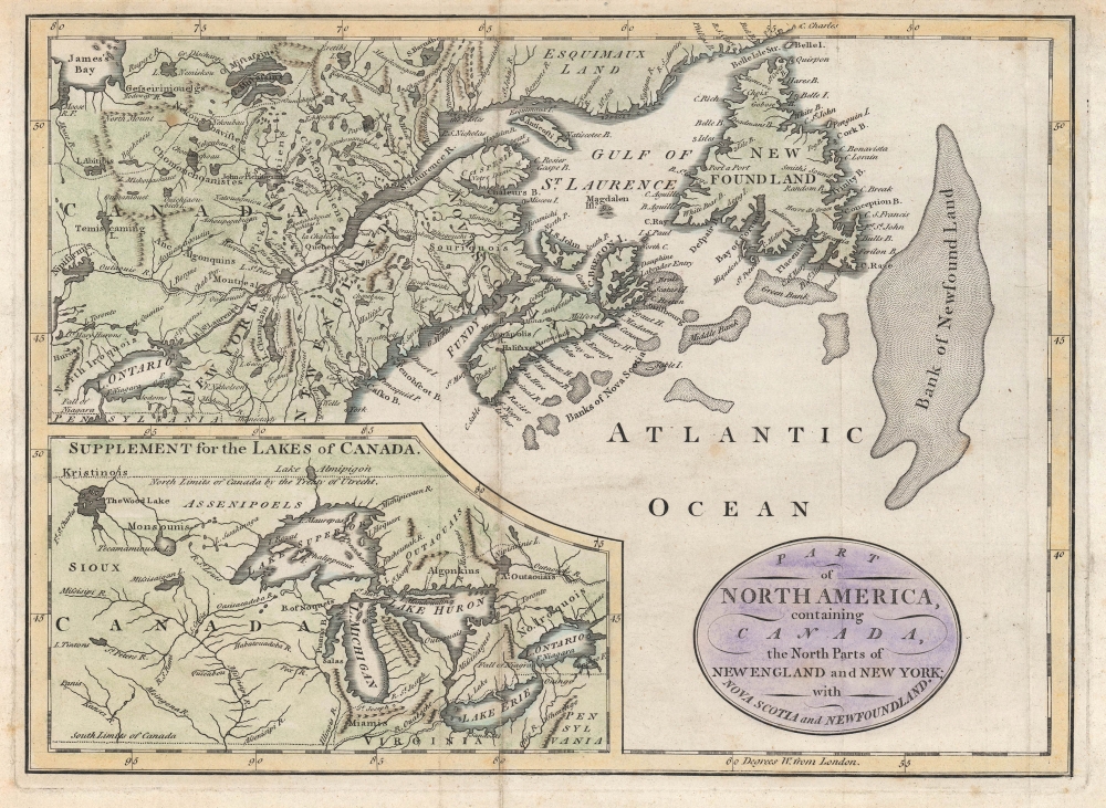
Part of North America, containing Canada, the north parts of New England and New York ; with Nova Scotia and Newfoundland.
1781 (undated) 8.25 x 11.5 in (20.955 x 29.21 cm) 1 : 10000000
1781 (undated) 8.25 x 11.5 in (20.955 x 29.21 cm) 1 : 10000000
Description
This is John Cary's c. 1781 map of the borderlands between the American colonies / United States of America and British dominions in North America. It is remarkable for reflecting geographical knowledge and territorial claims in the era of the American Revolutionary War.
However, Cary would also have been right to label these lands as part of Viginia based on the situation at the time of publication, due to the successful military campaigns of George Rogers Clark during the American Revolutionary War in 1777 - 1779. During his campaign, Ohio Country (including the territory of the future state of Ohio) and eastern Illinois Country became 'Illinois County, Virginia' by claim of conquest under the Virginia Colony charter. In 1782, this arrangement was ended, and the territory ceded to the United States, to be rearranged as part of the Northwest Territory soon afterwards. A portion of future Ohio was retained by Virginia as the Virginia Military District to settle veterans of the Revolutionary War, while Northeast Ohio, including Sandusky, was ceded to Connecticut and became the Connecticut Western Reserve.
A Closer Look
The main map covers from James Bay (the southern portion of Hudson Bay) to Lake Ontario to the Atlantic Ocean, taking in Northern New England and New York along with much of the British possessions in North America and the large inset at bottom-left covers the Great Lakes region. While towns, forts, and Native American groups are noted throughout (including 'Esquimaux Land' to the north), greater emphasis is placed on geographical features, such as waterways and mountains, as well as islands, bays, and banks in maritime areas. A rather generous 'South Limits of Canada' takes in all the Great Lakes except Lake Erie, while the northern boundary of New England reaches all the way to the St. Lawrence River.Virginia in Ohio?
One notable and curious feature of this map is that the northern portion of Ohio and Indiana (including the port of Sandusky, here as ' Sandoski') is marked as part of Virginia. This is likely due to the presence of the Ohio Company (officially the Ohio Company of Virginia) in these lands in the decades before the Revolutionary War. Though the Royal Proclamation of 1763 returned these lands to Native Americans, Cary might have retained the association with Virginia based on his cartographic sources (see 'Publication History and Census' below).However, Cary would also have been right to label these lands as part of Viginia based on the situation at the time of publication, due to the successful military campaigns of George Rogers Clark during the American Revolutionary War in 1777 - 1779. During his campaign, Ohio Country (including the territory of the future state of Ohio) and eastern Illinois Country became 'Illinois County, Virginia' by claim of conquest under the Virginia Colony charter. In 1782, this arrangement was ended, and the territory ceded to the United States, to be rearranged as part of the Northwest Territory soon afterwards. A portion of future Ohio was retained by Virginia as the Virginia Military District to settle veterans of the Revolutionary War, while Northeast Ohio, including Sandusky, was ceded to Connecticut and became the Connecticut Western Reserve.
Publication History and Census
Though no publication information is provided here, this map is generally attributed to John Cary and the details above suggest that it was produced around the year 1780. An alternate printing, listing John Fielding as the publisher in the bottom margin, is dated 1781 and is only independently cataloged by the Wisconsin Historical Society, while the present printing is only known by us to be held in the W. K. Morrison Special Collection at Nova Scotia Community College. The map is derived from Robert de Vaugondy's 1755 'Partie De L Amerique Septent. qui comprend La Nouvelle France ou le Canada,' which was then published in English by John Barrow before Cary re-engraved it in a somewhat smaller format. Along with the size and several minor details, Cary's map can be readily distinguished from Barrow's by the title cartouche, with the latter being more ornate.Cartographer
John Cary (1754 - 1835) was a London based cartographer active in the early part of the 19th century. Ronald Vere Tooley, the prominent English map historian, writes of Cary, "As an engraver he was elegant and exact with fine clear lettering and great delicacy of touch." Cary began his work as an engraver, cartographer, and globe maker in 1776 with his New and Correct English Atlas. This important atlas represented a new phase in cartography where accuracy and detail rose in prominence over the decorative embellishments of the 18th century. This change was indicative of the times when travel and commerce were expanding globally as never before. Cary's mastery of both engraving and cartography resulted in a series of seminal works that redefined mapmaking in the early 19th century. His stupendous Cary's New Universal Atlas, published in 1808, set the standard for all cartographers who followed. Cary reissued this seminal atlas in 1811, 1819, 1824, 1828, 1833, 1836 and 1844. Cary also did considerable work on the English Ordinance Survey prior to 1805. His cartographic work particularly inspired the Edinburgh school of cartography as represented by John Pinkerton and John Thomson. In America, Cary's work was used as the basis for Tanner's important New American Atlas. Cary's last published atlas appeared posthumously in 1844, however, by 1850 Cary's work was being carried on by his sons and other well-known cartographers including James Wyld, John Tallis & Company, and Crutchley. More by this mapmaker...
Condition
Good. Wear and toning along original fold lines. Verso repairs to fold separations. Small reinstated area along top margin with very slight loss.
References
OCLC 878424224 (alternate printing).