1744 Nicolas Bellin Map of Newfoundland
Newfoundland-bellin-1744$750.00

Title
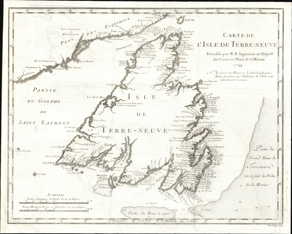
Carte De L'Isle de Terre-Neuve Dressée-par N. B. Ingenieur au Dépost des Cartes et Plans de la Marine 1744.
1744 (dated) 11.5 x 14.5 in (29.21 x 36.83 cm) 1 : 2425000
1744 (dated) 11.5 x 14.5 in (29.21 x 36.83 cm) 1 : 2425000
Description
This is the 1744 Bellin map of Newfoundland, a keystone map that set the standard for the mapping of the island for the third quarter of the 18th century. Newfoundland commanded a strategic position at the mouth of the St. Lawrence River, but its importance as a fishery would resonate throughout the century. The map's scope encompasses not only the island but also its position relative to the Labrador coast and the codfish-rich Grand Banks, emphasizing those important points.
Coastal Detail Surrounding Gaps of Knowledge
Bellin's notations are refreshingly frank. A note indicates in French that 'the courses of the rivers, the bottoms of several bays, as well as the interior of the Island are entirely unknown.' The coastline itself is well-understood, naming bays, harbors, capes, and islands in profusion, both for Newfoundland and Labrador. However, the vast areas inland reflect the remoteness of these lands and the extent to which they remained to be explored.The Source
Bellin prepared this map to be included in Pierre Francois Xavier de Charlevoix's (1682 - 1761) 1744 Histoire et description generale de la Nouvelle France, one of the most comprehensive works on North America predating the French and Indian War. Charlevoix was a Jesuit missionary and traveler commissioned by the French Crown and the Duke of Orleans to explore French holdings in the Americas, and this he did. Copies of the Histoire et Description Generale were found in the libraries of many 18th-century luminaries, including Voltaire, Franklin, and Jefferson. Jefferson particularly admired Charlevoix's work, calling it 'a particularly useful species of reading.'Publication History and Census
This map, as well as Charlevoix's Histoire et Description Generale, are well represented in institutional collections.Cartographer
Jacques-Nicolas Bellin (1703 - March 21, 1772) was one of the most important cartographers of the 18th century. With a career spanning some 50 years, Bellin is best understood as geographe de cabinet and transitional mapmaker spanning the gap between 18th and early-19th century cartographic styles. His long career as Hydrographer and Ingénieur Hydrographe at the French Dépôt des cartes et plans de la Marine resulted in hundreds of high quality nautical charts of practically everywhere in the world. A true child of the Enlightenment Era, Bellin's work focuses on function and accuracy tending in the process to be less decorative than the earlier 17th and 18th century cartographic work. Unlike many of his contemporaries, Bellin was always careful to cite his references and his scholarly corpus consists of over 1400 articles on geography prepared for Diderot's Encyclopedie. Bellin, despite his extraordinary success, may not have enjoyed his work, which is described as "long, unpleasant, and hard." In addition to numerous maps and charts published during his lifetime, many of Bellin's maps were updated (or not) and published posthumously. He was succeeded as Ingénieur Hydrographe by his student, also a prolific and influential cartographer, Rigobert Bonne. More by this mapmaker...
Source
Charlevoix, Pierre François Xavier de, Histoire et Description Generale de la Nouvelle France, avec le journal historique d'un voyage fait par ordre du roi dans l'Amérique Septentrionnale, (Paris) 1744.
Condition
Very good. Faint offsetting. Margin reinstated at lower left not impacting image. Short tear at insertion point just touching border. Else excellent.
References
OCLC 61561147. Kershaw, K., Early Printed Maps of Canada, #515.